METAR & TAF 7M2
7M2 does not publish a METAR.
Showing the nearest reporting station: KBVX (BATESVILLE RGNL) · 23.1 NM away. Conditions at 7M2 may differ.
METAR · KBVX
Observed 16:56Z
KBVX 271656Z AUTO 13005KT 10SM CLR 34/25 A2995 RMK AO2 SLP138 T03440250 $
- Wind
- 130° @ 5 kt
- Visibility
- 10 SM
- Temp / Dew
- 34°C / 25°C
- Altimeter
- 29.95 inHg
- Clouds
- CLR
- Density alt
- 3,241 ft
- Ceiling
- Unlimited
- Rules
- VFR
Airport info & contacts
Manager on record, flight service, ARTCC, attendance schedule and pattern altitude — published by the FAA and refreshed every 28 days.
Location
- From city
- 2 NM E
- VFR sectional
- MEMPHIS
- ARTCC
- ZME · MEMPHIS
- NOTAM facility
- JBR (NOTAM-D)
Airport manager
- Name
- LARRY SNYDER
- Phone
- 501-203-8644
- Address
- 1501 AIRPORT LANE, MOUNTAIN VIEW AR 72560
Flight service · Hours
- FSS JBR
- JONESBORO1-800-WX-BRIEF
- Attendance
- Unattended
Frequencies
Tap any row to copy the frequency to your clipboard.
Runways & pattern
Full pagePattern entry · RWY 09
LEFT TRAFFICRunway end performance
| End | TORA | TODA | ASDA | LDA | VGSI | Approach lights | Obstruction |
|---|---|---|---|---|---|---|---|
| 09 | — | — | — | — | — | — | 21', bldg, 435' from thr, 110' R of cntrln, slope 11 |
| 27 | — | — | — | — | — | — | 355', tower, 5280' from thr, 0' R of cntrln, slope 14 |
Declared distances in feet. TORA = takeoff run available, TODA = takeoff distance, ASDA = accelerate-stop, LDA = landing distance.
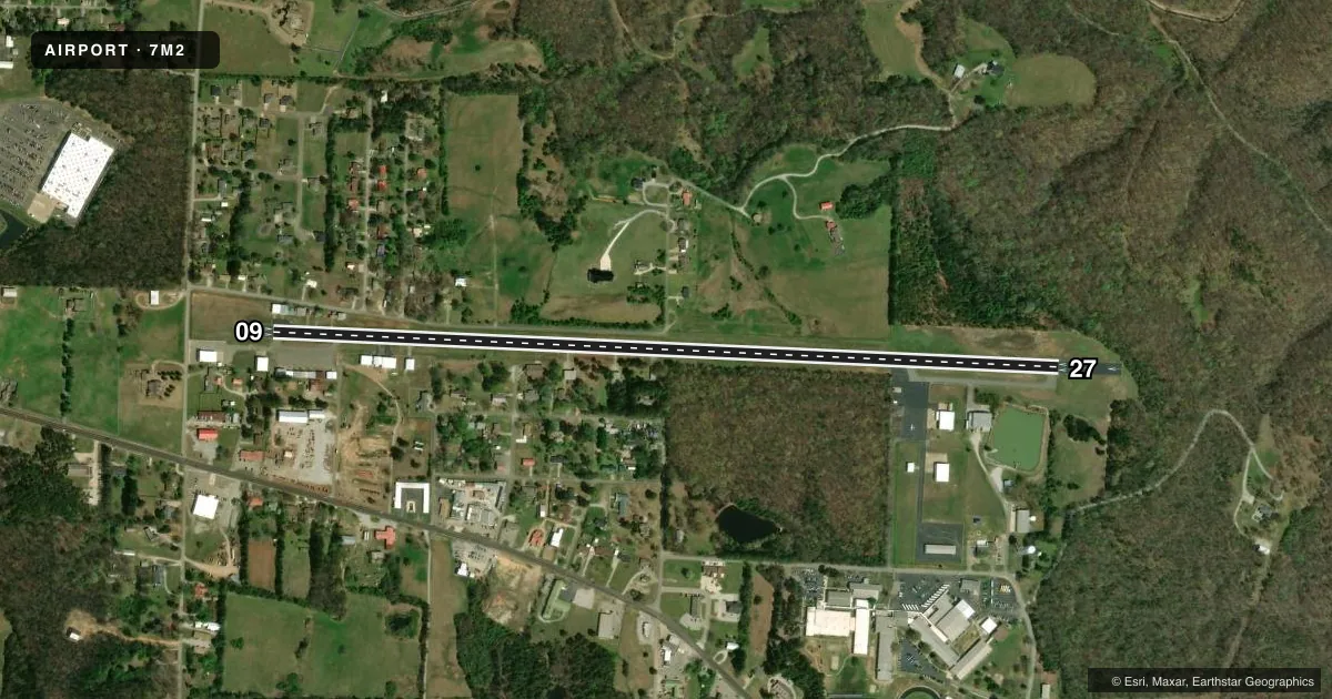
Airport sketch
Runways drawn to scale from FAA survey coordinates, rendered over satellite imagery. Not for navigation.
Approaches & charts
Services on the field
Fuel grades, oxygen, maintenance, ramp storage and lighting — as declared to the FAA by the airport operator.
Fuel & services
- Fuel
- 100LL
- Oxygen (bottled)
- Not available
- Airframe repair
- Not available
- Power plant repair
- Not available
Ramp & ground
- Transient storage
- Tie-down
- Hangar
- Landing fee
- No fee published
- Customs
- Not available
- Lighting schedule
- SEE RMK
- Beacon schedule
- SS-SR
- Beacon
- White / Green (civil land)(WG)
- Wind indicator
- Lighted
- Segmented circle
- No
Fuel & FBOs
Cheapest 100LL and Jet A on the field and nearby. Always confirm with the FBO before taxi.
Airport notes
Surface conditions, obstructions, local procedures, lighting outages and other notes published with each FAA cycle.
General notes
- (E81) TWY EXIT LIGHT AT END RWY 09.
- RY 27 HAS A 15 FT DROPOFF 400 FT FM THLD.
- DEER & COYOTES ON & INVOF ARPT.
- FOR CD CTC MEMPHIS ARTCC AT 901-368-8453/8449.
Lighting notes
- MIRL RWY 09/27 -CTAF (3 - LOW, 5- MED, 7 - HIGH)
Fuel notes
- 100LLSELF-SERVICE FUEL AVBL 24 HRS WITH CREDIT CARD.
Approach & departure obstructions
- 276-8 FT BRUSH APRX 50 FT FM RWY END.
- 09FTW FPO.
- 27FTW FPO.
Other notes
- PRE DATES THE ACT.
- 1FOR SVC AFT HRS CALL 501-203-8644.
VFR map & nearby airports
VFR sectional. Tap any ICAO chip to open that airport.
Key facts · 7M2
Answer card- ICAO
- 7M2
- Name
- MOUNTAIN VIEW WILCOX MEML FLD
- Location
- MOUNTAIN VIEW, ARKANSAS
- Elevation
- 805 ft MSL
- Traffic pattern altitude
- 1,805 ft MSL (1,000 AGL)
- Control tower
- Non-towered (use CTAF)
- Total runways
- 1
- Longest runway
- 09/27 · 4,502 ft
- Published ILS approaches
- 0
- Published frequencies
- 2
- Magnetic variation
- 1°
- Current flight rules
- VFR
- Current wind
- 130° at 5 kt
- Favored runway now
- RWY 09
Mountain View Wilcox Meml Fld sits in Mountain View, Arkansas. Field elevation is 805 ft MSL. The airport has one runway. Runway 09/27 is 4,502 ft long with an asphalt surface. The field is not towered. CTAF and UNICOM are both 122.7. No ILS approaches are published here.
Pattern altitude is not published. Use 1,000 ft AGL for light piston traffic unless local procedures or the current Chart Supplement say otherwise. The airport has one on-field FBO. Mountain View Airport is on the field. It carries AVGAS 100LL. Self-serve 100LL is available 24 hours with credit card. For service after hours, call the number in the field data before you go.
A few operational notes matter here. Deer and coyotes are reported on and near the airport. Runway 27 has a 15-foot dropoff 400 feet from the threshold. Medium intensity runway lights are available on 09/27 and are controlled by CTAF. Use the published light settings before night ops. If you need clearance delivery, contact Memphis ARTCC. This is a good strip to brief carefully before arrival. Check the current FAA Chart Supplement for any noise or curfew restrictions before flying into the field.