METAR & TAF KCCA
Current METAR
Observed 16:35Z
KCCA 271635Z AUTO 00000KT 10SM CLR 35/22 A2994 RMK AO2
- Wind
- 000° @ 0 kt
- Visibility
- 10 SM
- Temp / Dew
- 35°C / 22°C
- Altimeter
- 29.94 inHg
- Clouds
- CLR
- Density alt
- 3,012 ft
- Ceiling
- Unlimited
- Rules
- VFR
Airport info & contacts
Manager on record, flight service, ARTCC, attendance schedule and pattern altitude — published by the FAA and refreshed every 28 days.
Location
- From city
- 1 NM NE
- VFR sectional
- MEMPHIS
- ARTCC
- ZME · MEMPHIS
- NOTAM facility
- CCA (NOTAM-D)
Airport manager
- Name
- WADE WHERRY
- Phone
- 501-745-6550
- Address
- PO BOX 910, CLINTON AR 72031
Flight service · Hours
- FSS JBR
- JONESBORO1-800-WX-BRIEF
- Attendance
- MON-FRI · 0800-1700
Frequencies
Tap any row to copy the frequency to your clipboard.
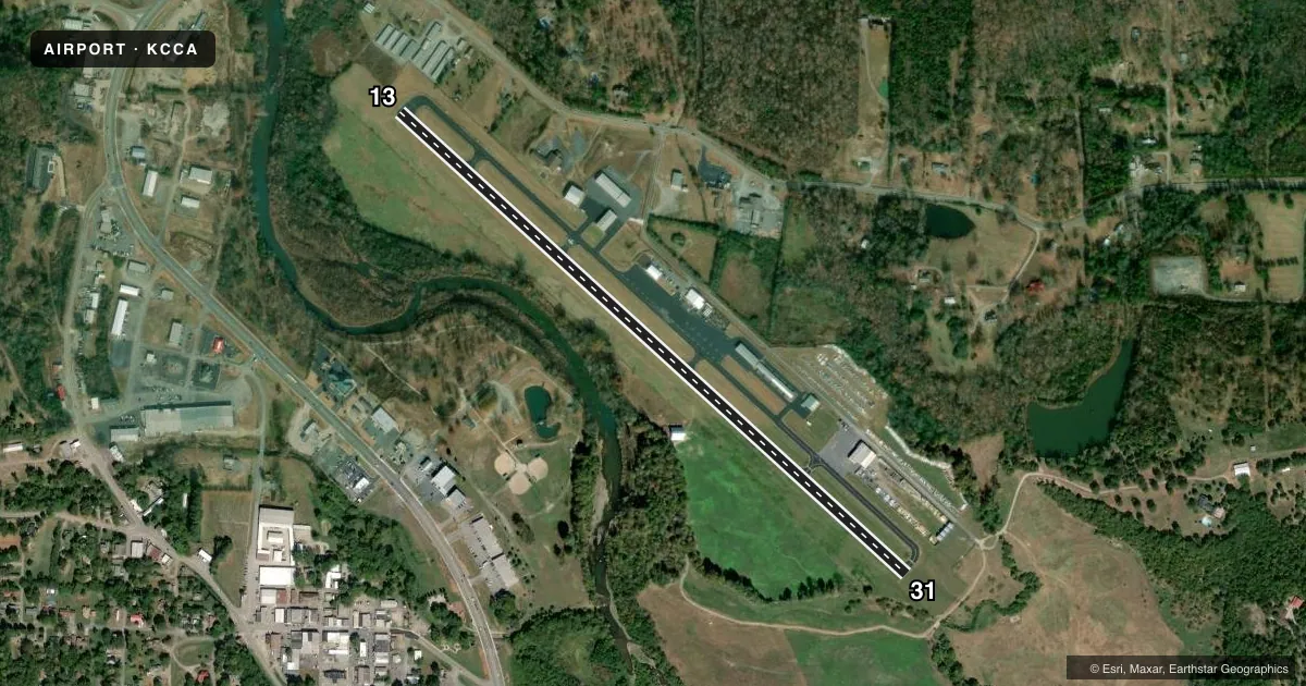
Runways & pattern
Full pagePattern entry · RWY 13
LEFT TRAFFICRunway end performance
| End | TORA | TODA | ASDA | LDA | VGSI | Approach lights | Obstruction |
|---|---|---|---|---|---|---|---|
| 13 | — | — | — | — | — | — | 45', trees, 1000' from thr, 50' R of cntrln, slope 17 |
| 31 | — | — | — | — | PAPI 2-box left(4°) | — | 45', trees, 650' from thr, 250' R of cntrln, slope 10 |
Declared distances in feet. TORA = takeoff run available, TODA = takeoff distance, ASDA = accelerate-stop, LDA = landing distance.
Airport sketch
Runways drawn to scale from FAA survey coordinates, rendered over satellite imagery. Not for navigation.
Approaches & charts
Services on the field
Fuel grades, oxygen, maintenance, ramp storage and lighting — as declared to the FAA by the airport operator.
Fuel & services
- Fuel
- 100LL
- Oxygen (bottled)
- Not available
- Oxygen (bulk)
- Not available
- Airframe repair
- Major
- Power plant repair
- Major
- Other services
- SALES
Ramp & ground
- Transient storage
- Tie-down
- Hangar
- Landing fee
- No fee published
- Lighting schedule
- SEE RMK
- Beacon schedule
- SS-SR
- Beacon
- White / Green (civil land)(WG)
- Wind indicator
- Yes
- Segmented circle
- No
Fuel & FBOs
Cheapest 100LL and Jet A on the field and nearby. Always confirm with the FBO before taxi.
Airport notes
Surface conditions, obstructions, local procedures, lighting outages and other notes published with each FAA cycle.
General notes
- USE EXTREME CARE RAPIDLY RISING TERRAIN 3 MILES SW THRU NE.
- USE EXTREME CARE RAPIDLY RISING TERRAIN 3 MILES NW OF ARPT.
- DEER ON & INVOF ARPT.
- FOR CD CTC MEMPHIS ARTCC AT 901-368-8453/8449.
Lighting notes
- DUSK-DAWN. ACTVT REIL RWY 13/31; PAPI RWY 31; MIRL RWY 13/31 - CTAF.
Fuel notes
- 100LL24 HR SELF SVC FUEL AVBL WITH CREDIT CARD.
VFR map & nearby airports
VFR sectional. Tap any ICAO chip to open that airport.
Key facts · KCCA
Answer card- ICAO
- KCCA
- Name
- CLINTON MUNI
- Location
- CLINTON, ARKANSAS
- Elevation
- 513.9 ft MSL
- Traffic pattern altitude
- 1,513.9 ft MSL (1,000 AGL)
- Control tower
- Non-towered (use CTAF)
- Total runways
- 1
- Longest runway
- 13/31 · 4,007 ft
- Published ILS approaches
- 0
- Published frequencies
- 2
- Magnetic variation
- 0°
- Current flight rules
- VFR
- Current wind
- 000° at 0 kt
- Favored runway now
- –
Clinton Muni (KCCA) sits in Clinton, Arkansas. Field elevation is 513.9 ft MSL. The airport has one runway. Runway 13/31 is 4,007 ft of asphalt, which is the longest runway on the field. There is no control tower. CTAF and UNICOM are both 122.7.
No ILS approaches are published here. Pattern altitude is not published, so use the standard 1,000 ft AGL for light piston operations unless the current Chart Supplement says otherwise. Dawson Aircraft is on the field. It carries 100LL. Twenty-four hour self-service fuel is available with a credit card.
This is a field where terrain matters. The Chart Supplement calls for extreme care because terrain rises quickly three miles southwest through northeast. It also warns about rapidly rising terrain three miles northwest of the airport. Deer are reported on and near the airport, so expect wildlife on taxi, takeoff and landing. Runway lighting is pilot-controlled through the CTAF. The runway end identifier lights are active from dusk to dawn. Runway 31 has a precision approach path indicator. For clearance delivery, Memphis ARTCC is listed in the remarks. Check current procedures before departure if you need IFR service or want the latest operational notes.