METAR & TAF KCXW
Current METAR
Observed 13:35Z
KCXW 271335Z AUTO 22003KT 10SM CLR 30/28 A2996 RMK A01
- Wind
- 220° @ 3 kt
- Visibility
- 10 SM
- Temp / Dew
- 30°C / 28°C
- Altimeter
- 29.96 inHg
- Clouds
- CLR
- Density alt
- 2,093 ft
- Ceiling
- Unlimited
- Rules
- VFR
Airport info & contacts
Manager on record, flight service, ARTCC, attendance schedule and pattern altitude — published by the FAA and refreshed every 28 days.
Location
- From city
- 7 NM SW
- VFR sectional
- MEMPHIS
- ARTCC
- ZME · MEMPHIS
- NOTAM facility
- JBR
Airport manager
- Name
- JACOB BRILEY
- Phone
- 501-358-6200
- Address
- 3250 SAND GAP ROAD, CONWAY AR 72034
Flight service · Hours
- FSS JBR
- JONESBORO1-800-WX-BRIEF
- Attendance
- 0800-1800
Frequencies
Tap any row to copy the frequency to your clipboard.
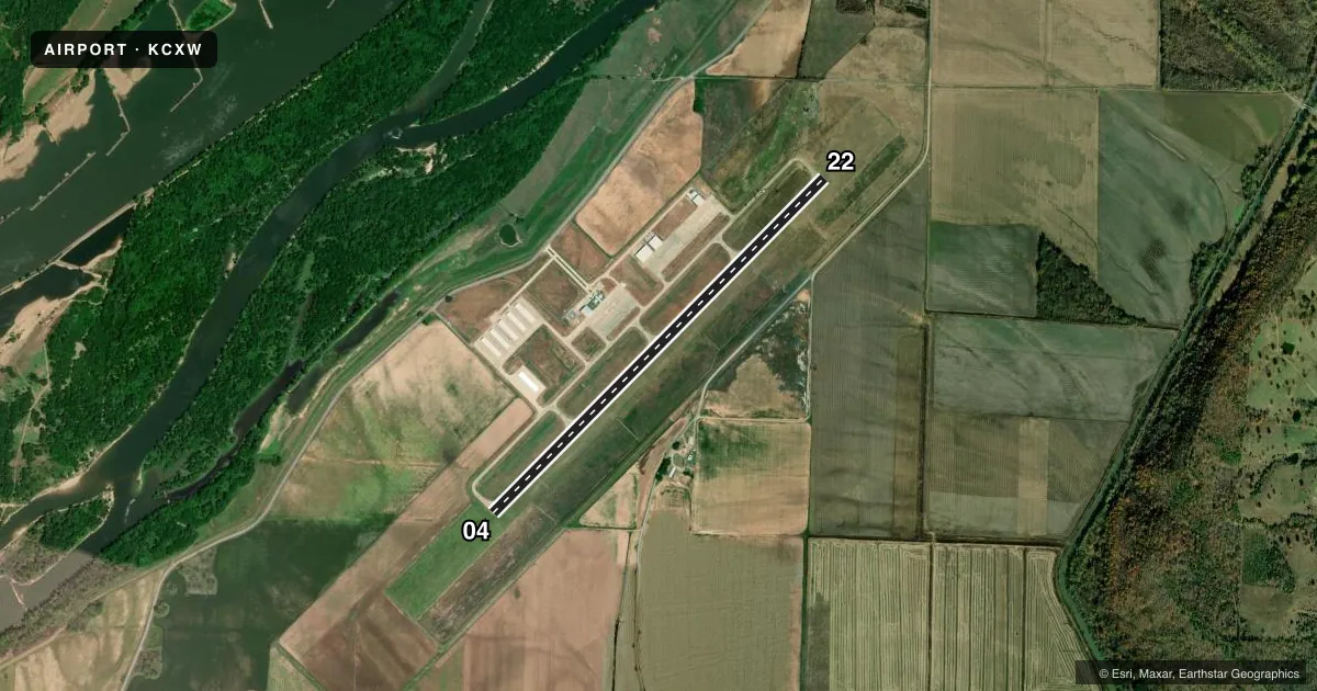
Runways & pattern
Full pagePattern entry · RWY 22
LEFT TRAFFICRunway end performance
| End | TORA | TODA | ASDA | LDA | VGSI | Approach lights | Obstruction |
|---|---|---|---|---|---|---|---|
| 04 | — | — | — | — | PAPI 2-box left(3°) | — | — |
| 22 | — | — | — | — | PAPI 2-box left(3°) | — | — |
Declared distances in feet. TORA = takeoff run available, TODA = takeoff distance, ASDA = accelerate-stop, LDA = landing distance.
Airport sketch
Runways drawn to scale from FAA survey coordinates, rendered over satellite imagery. Not for navigation.
Approaches & charts
Services on the field
Fuel grades, oxygen, maintenance, ramp storage and lighting — as declared to the FAA by the airport operator.
Fuel & services
- Fuel
- 100LLA
- Airframe repair
- Major
- Power plant repair
- Major
- Other services
- INSTR,RNTL
Ramp & ground
- Transient storage
- Tie-down
- Hangar
- Landing fee
- Yes
- Lighting schedule
- SEE RMK
- Beacon schedule
- SS-SR
- Beacon
- White / Green (civil land)(WG)
- Wind indicator
- Lighted
- Segmented circle
- Yes
Fuel & FBOs
Cheapest 100LL and Jet A on the field and nearby. Always confirm with the FBO before taxi.
Airport notes
Surface conditions, obstructions, local procedures, lighting outages and other notes published with each FAA cycle.
General notes
- FOR CD WHEN UNA VIA FREQ CTC LITTLE ROCK APCH 501-379-2908 OR LITTLE ROCK ATCT 501-379-2911
Lighting notes
- ACTVT REIL, PAPI AND MIRL RWYS 4 AND 22 - CTAF.
Fuel notes
- 100LLFUEL AVBL 24 HRS SELF SVC WITH CREDIT CARD (100LL).
Other notes
- FEE WAIVED IF FUEL IS PURCHASED.
- 1FOR SVC AFT HRS CALL 501-697-6476.
VFR map & nearby airports
VFR sectional. Tap any ICAO chip to open that airport.
Key facts · KCXW
Answer card- ICAO
- KCXW
- Name
- CONWAY RGNL
- Location
- CONWAY, ARKANSAS
- Elevation
- 276.1 ft MSL
- Traffic pattern altitude
- 1,276.1 ft MSL (1,000 AGL)
- Control tower
- Non-towered (use CTAF)
- Total runways
- 1
- Longest runway
- 04/22 · 5,500 ft
- Published ILS approaches
- 0
- Published frequencies
- 9
- Magnetic variation
- 1°
- Current flight rules
- VFR
- Current wind
- 220° at 3 kt
- Favored runway now
- RWY 22
CONWAY RGNL sits in Conway, Arkansas. The field elevation is 276.1 ft MSL. It has one runway, 04/22, at 5,500 ft. There is no control tower. Pattern altitude is not published. Use 1,000 ft AGL for light piston traffic unless the current Chart Supplement says otherwise.
No ILS approaches are published here. The airport is served by Little Rock Approach for approach and departure services. Published frequencies include CTAF and UNICOM on 123.05. Runway 4 and runway 22 have runway end identifier lights, PAPI and medium intensity runway lights that are activated on CTAF.
Conway Regional Airport is the on-field FBO. It carries 100LL and Jet A. Fuel is available 24 hours self service with credit card for 100LL. The landing fee is waived if fuel is purchased. For service after hours, call the number in the Chart Supplement or the airport operator. If you need clearance delivery when unassigned via frequency, contact Little Rock Approach or the tower numbers listed in the remarks. First-time arrivals should plan for a non-towered field with published lighting and no ILS. Check the current Chart Supplement for any noise or curfew restrictions before flying into the field.