METAR & TAF KBDQ
Current METAR
Observed 14:55Z
KBDQ 271455Z AUTO VRB03KT 10SM CLR 32/21 A2996 RMK AO2
- Wind
- VAR @ 3 kt
- Visibility
- 10 SM
- Temp / Dew
- 32°C / 21°C
- Altimeter
- 29.96 inHg
- Clouds
- CLR
- Density alt
- 2,389 ft
- Ceiling
- Unlimited
- Rules
- VFR
Airport info & contacts
Manager on record, flight service, ARTCC, attendance schedule and pattern altitude — published by the FAA and refreshed every 28 days.
Location
- From city
- 2 NM SE
- VFR sectional
- MEMPHIS
- ARTCC
- ZME · MEMPHIS
- NOTAM facility
- JBR (NOTAM-D)
Airport manager
- Name
- GLEN CASTO
- Phone
- (501) 306-5656
- Address
- 1 AIRPORT ROAD, MORRILTON AR 72110
Flight service · Hours
- FSS JBR
- JONESBORO1-800-WX-BRIEF
- Attendance
- 0800-1800
Frequencies
Tap any row to copy the frequency to your clipboard.
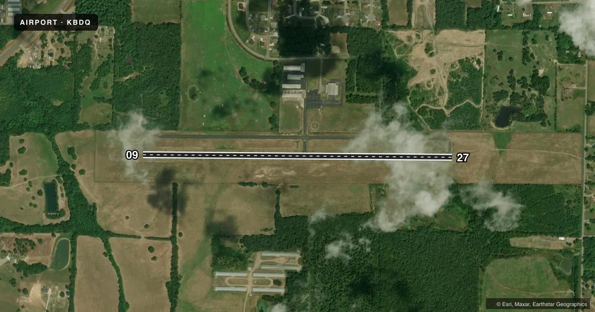
Runways & pattern
Full pagePattern entry · RWY 09
LEFT TRAFFICRunway end performance
| End | TORA | TODA | ASDA | LDA | VGSI | Approach lights | Obstruction |
|---|---|---|---|---|---|---|---|
| 09 | — | — | — | — | — | — | 40', tree, 975' from thr, 125' R of cntrln, slope 19 |
| 27 | — | — | — | — | PAPI 2-box left | — | 50', trees, 1750' from thr, 0' R of cntrln, slope 31 |
Declared distances in feet. TORA = takeoff run available, TODA = takeoff distance, ASDA = accelerate-stop, LDA = landing distance.
Airport sketch
Runways drawn to scale from FAA survey coordinates, rendered over satellite imagery. Not for navigation.
Approaches & charts
Services on the field
Fuel grades, oxygen, maintenance, ramp storage and lighting — as declared to the FAA by the airport operator.
Fuel & services
- Fuel
- 100LLA+
- Airframe repair
- Major
- Power plant repair
- Major
- Other services
- AGRI
Ramp & ground
- Transient storage
- Tie-down
- Hangar
- Landing fee
- No fee published
- Lighting schedule
- SEE RMK
- Beacon schedule
- SS-SR
- Beacon
- White / Green (civil land)(WG)
- Wind indicator
- Lighted
- Segmented circle
- Yes
Fuel & FBOs
Cheapest 100LL and Jet A on the field and nearby. Always confirm with the FBO before taxi.
Airport notes
Surface conditions, obstructions, local procedures, lighting outages and other notes published with each FAA cycle.
General notes
- ULTRALIGHT ACTIVITY ON & INVOF ARPT.
- DEER ON & INVOF ARPT.
- FOR CD CTC MEMPHIS ARTCC AT 901-368-8453/8449.
- FOR AFTER HRS SVC PLEASE CALL 501-306-5656.
Lighting notes
- ACTVT MIRL RWY 09/27 - 122.9.
Fuel notes
- 100LLJET A & 100LL FUEL SELF SVC WITH CREDIT CARD.
Approach & departure obstructions
- 09RUNWAY MAKINGS FADED 9 AND 27.
- 27RUNWAY MAKINGS FADED 9 AND 27
VFR map & nearby airports
VFR sectional. Tap any ICAO chip to open that airport.
Key facts · KBDQ
Answer card- ICAO
- KBDQ
- Name
- MORRILTON MUNI
- Location
- MORRILTON, ARKANSAS
- Elevation
- 321.4 ft MSL
- Traffic pattern altitude
- 1,321.4 ft MSL (1,000 AGL)
- Control tower
- Non-towered (use CTAF)
- Total runways
- 1
- Longest runway
- 09/27 · 3,998 ft
- Published ILS approaches
- 0
- Published frequencies
- 2
- Magnetic variation
- 0°
- Current flight rules
- VFR
- Current wind
- 000° at 3 kt
- Favored runway now
- RWY 09
Morrilton Muni is in Morrilton, Arkansas. Field elevation is 321.4 ft MSL. The airport has one runway, 09/27, which is 3,998 ft long. There is no control tower. CTAF and UNICOM are both 122.8. No ILS approaches are published here.
Pattern altitude is not published. Use the standard 1,000 ft AGL pattern for light piston operations unless the current Chart Supplement says otherwise. The on-field FBO is Morrilton Municipal Airport. It carries 100LL and Jet A. Fuel is self-service with credit card. After-hours service is handled by phone at the number listed for the field.
A few local items matter here. Ultralight activity occurs on and near the airport. Deer are also reported on and in the vicinity of the field. Runway markings on 09 and 27 are faded, so brief your rollout and lineup carefully. Medium intensity runway lights on 09/27 are activated on 122.9. For clearance delivery, contact Memphis ARTCC using the numbers in the Chart Supplement. This is a non-towered airport, so expect local traffic calls and self-announce discipline. Check the current Chart Supplement for any updates before departure.