METAR & TAF KRUE
Current METAR
Observed 16:53Z
KRUE 271653Z AUTO VRB03KT 10SM CLR 36/21 A2994 RMK AO2 SLP128 T03560211
- Wind
- VAR @ 3 kt
- Visibility
- 10 SM
- Temp / Dew
- 36°C / 21°C
- Altimeter
- 29.94 inHg
- Clouds
- CLR
- Density alt
- 3,003 ft
- Ceiling
- Unlimited
- Rules
- VFR
Airport info & contacts
Manager on record, flight service, ARTCC, attendance schedule and pattern altitude — published by the FAA and refreshed every 28 days.
Location
- From city
- 2 NM SE
- VFR sectional
- MEMPHIS
- Pattern altitude
- 1,005 ft AGL · 1,414 ft MSL
- ARTCC
- ZME · MEMPHIS
- NOTAM facility
- RUE (NOTAM-D)
Airport manager
- Name
- PATRICK KARP
- Phone
- 479-967-1227
- Address
- 1759 AIRPORT ROAD, RUSSELLVILLE AR 72802
Flight service · Hours
- FSS JBR
- JONESBORO1-800-WX-BRIEF
- Attendance
- SAT-SUN · 0800-1800
- NOV-MAR · M-F · 0730-1730
- MAR-NOV · M-F · 0730-1830
Frequencies
Tap any row to copy the frequency to your clipboard.
Runways & pattern
Full pagePattern entry · RWY 07
LEFT TRAFFICRunway end performance
| End | TORA | TODA | ASDA | LDA | VGSI | Approach lights | Obstruction |
|---|---|---|---|---|---|---|---|
| 07 | — | — | — | — | PAPI 4-box left(3°) | — | 35', tree, 1475' from thr, 125' R of cntrln, slope 36 |
| 25 | — | — | — | — | PAPI 4-box left(4°) | — | 78', tree, 1825' from thr, 115' R of cntrln, slope 20 |
Declared distances in feet. TORA = takeoff run available, TODA = takeoff distance, ASDA = accelerate-stop, LDA = landing distance.
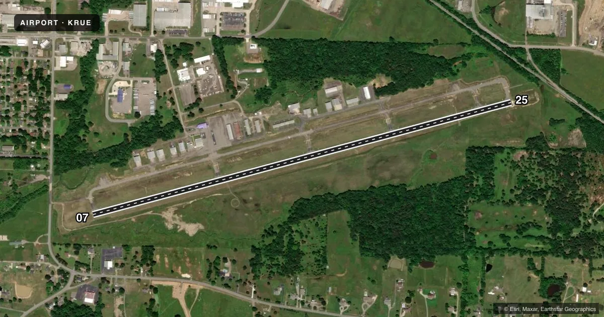
Airport sketch
Runways drawn to scale from FAA survey coordinates, rendered over satellite imagery. Not for navigation.
Approaches & charts
Services on the field
Fuel grades, oxygen, maintenance, ramp storage and lighting — as declared to the FAA by the airport operator.
Fuel & services
- Fuel
- 100LLA
- Oxygen (bottled)
- Not available
- Oxygen (bulk)
- Not available
- Airframe repair
- Not available
- Power plant repair
- Not available
- Other services
- AFRT,AGRI,AMB,INSTR
Ramp & ground
- Transient storage
- Tie-down
- Landing fee
- No fee published
- Customs
- Not available
- Lighting schedule
- SEE RMK
- Beacon schedule
- SS-SR
- Beacon
- White / Green (civil land)(WG)
- Wind indicator
- Lighted
Fuel & FBOs
Cheapest 100LL and Jet A on the field and nearby. Always confirm with the FBO before taxi.
Airport notes
Surface conditions, obstructions, local procedures, lighting outages and other notes published with each FAA cycle.
General notes
- FLOCKS OF MIGRATORY BIRDS INVOF ARPT.
- DEER ON & INVOF RY.
- FOR CD CTC MEMPHIS ARTCC AT 901-368-8453/8449.
- HELI SERVICE CENTER ON FLD.
Lighting notes
- DUSK-DAWN. ACTVT REIL RWYS 07 & 25; PAPI RWYS 07 & 25; MIRL 07/25 - CTAF.
Fuel notes
- 100LLSELF SVC FUEL AVBL 24 HRS WITH CREDIT CARD (100 LL)
Approach & departure obstructions
- 25APCH SLOPE 29:1 TO DSPLCD THLD.
Other notes
- OPN SHADE HNGRS, LIMITED AVAILABLILITY.
- 5FOR SVC AFT HRS CALL 479-857-0362 OR 479-857-4076.
VFR map & nearby airports
VFR sectional. Tap any ICAO chip to open that airport.
Key facts · KRUE
Answer card- ICAO
- KRUE
- Name
- RUSSELLVILLE RGNL
- Location
- RUSSELLVILLE, ARKANSAS
- Elevation
- 409.2 ft MSL
- Traffic pattern altitude
- 1,414.2 ft MSL (1,005 AGL)
- Control tower
- Non-towered (use CTAF)
- Total runways
- 1
- Longest runway
- 07/25 · 5,505 ft
- Published ILS approaches
- 0
- Published frequencies
- 2
- Magnetic variation
- 3°
- Current flight rules
- VFR
- Current wind
- 000° at 3 kt
- Favored runway now
- RWY 07
Russellville Rgnl sits in Russellville, Arkansas. Field elevation is 409.2 ft MSL. The airport has one runway. Runway 07/25 is 5,505 ft of asphalt, so it gives you the only paved landing option on the field.
This is an untowered airport. CTAF and UNICOM are both 122.7. The published pattern altitude is 1,005 ft AGL, which is 1,414.2 ft MSL. No ILS approaches are published here, so plan with the current chart and the approach options you have available.
Russellville Regional Airport is the on-field FBO. It carries 100LL and Jet A. Self-serve 100LL is available 24 hours with credit card. Open shade hangars are available, though availability is limited. For after-hours service, the published remarks list phone numbers to call.
A first-time pilot should pay attention to the local hazards. Deer are reported on and near the runway. Migratory birds are also in the area. Runway 25 has a published 29 to 1 approach slope to the displaced threshold. Lighting is pilot-controlled from dusk to dawn through CTAF. That includes REIL, PAPI and MIRL on runway 07/25. If you need clearance delivery, contact Memphis ARTCC using the published numbers before departure.