METAR & TAF H35
H35 does not publish a METAR.
Showing the nearest reporting station: KRUE (RUSSELLVILLE RGNL) · 20.7 NM away. Conditions at H35 may differ.
METAR · KRUE
Observed 08:53Z
KRUE 270853Z AUTO 00000KT 10SM CLR 26/23 A2991 RMK AO2 SLP119 T02560233 56003
- Wind
- 000° @ 0 kt
- Visibility
- 10 SM
- Temp / Dew
- 26°C / 23°C
- Altimeter
- 29.91 inHg
- Clouds
- CLR
- Density alt
- 1,929 ft
- Ceiling
- Unlimited
- Rules
- VFR
Airport info & contacts
Manager on record, flight service, ARTCC, attendance schedule and pattern altitude — published by the FAA and refreshed every 28 days.
Location
- From city
- 3 NM E
- VFR sectional
- MEMPHIS
- Pattern altitude
- 967 ft AGL · 1,448 ft MSL
- ARTCC
- ZME · MEMPHIS
- NOTAM facility
- JBR (NOTAM-D)
Airport manager
- Name
- JIM LOONEY
- Phone
- 479-264-8408
- Address
- 205 WALNUT, CLARKSVILLE AR 72830
Flight service · Hours
- FSS JBR
- JONESBORO1-800-WX-BRIEF
- Attendance
- DALGT
Frequencies
Tap any row to copy the frequency to your clipboard.
Runways & pattern
Full pagePattern entry · RWY 09
LEFT TRAFFICRunway end performance
| End | TORA | TODA | ASDA | LDA | VGSI | Approach lights | Obstruction |
|---|---|---|---|---|---|---|---|
| 09 | — | — | — | — | PAPI 2-box left(4°) | — | 70', trees, 900' from thr, 280' R of cntrln, slope 10 |
| 27 | — | — | — | — | PAPI 2-box left(4°) | — | 60', tree, 900' from thr, 275' R of cntrln, slope 11 |
Declared distances in feet. TORA = takeoff run available, TODA = takeoff distance, ASDA = accelerate-stop, LDA = landing distance.
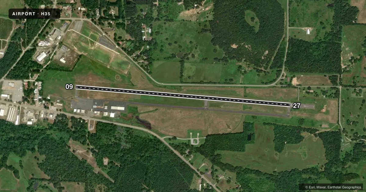
Airport sketch
Runways drawn to scale from FAA survey coordinates, rendered over satellite imagery. Not for navigation.
Approaches & charts
Services on the field
Fuel grades, oxygen, maintenance, ramp storage and lighting — as declared to the FAA by the airport operator.
Fuel & services
- Fuel
- 100LLA
- Oxygen (bottled)
- Not available
- Oxygen (bulk)
- Not available
- Airframe repair
- Major
- Power plant repair
- Major
- Other services
- INSTR,PAJA,RNTL
Ramp & ground
- Transient storage
- Tie-down
- Landing fee
- No fee published
- Customs
- Not available
- Lighting schedule
- SEE RMK
- Beacon schedule
- SS-SR
- Beacon
- White / Green (civil land)(WG)
- Wind indicator
- Lighted
- Segmented circle
- Yes
Fuel & FBOs
Cheapest 100LL and Jet A on the field and nearby. Always confirm with the FBO before taxi.
Airport notes
Surface conditions, obstructions, local procedures, lighting outages and other notes published with each FAA cycle.
General notes
- WILDLIFE ON & INVOF ARPT.
- FOR CD CTC MEMPHIS ARTCC AT 901-368-8453/8449.
Lighting notes
- PAPI RWY 9 & 27 OPR CONSLY; MIRL RWY 09/27 ON SS-SR.
Fuel notes
- 100LLSELF SRV FUEL AVBL 24 HRS WITH CREDIT CARD (100LL & JET A).
Approach & departure obstructions
- 27PAPI UNUSBL BYD 8 DEGS RIGHT OF CNTRLN.
Other notes
- MANAGEROR 479-243-6604 FOR MAINT.
VFR map & nearby airports
VFR sectional. Tap any ICAO chip to open that airport.
Key facts · H35
Answer card- ICAO
- H35
- Name
- CLARKSVILLE MUNI
- Location
- CLARKSVILLE, ARKANSAS
- Elevation
- 480.8 ft MSL
- Traffic pattern altitude
- 1,447.8 ft MSL (967 AGL)
- Control tower
- Non-towered (use CTAF)
- Total runways
- 1
- Longest runway
- 09/27 · 4,504 ft
- Published ILS approaches
- 0
- Published frequencies
- 2
- Magnetic variation
- 4°
- Current flight rules
- VFR
- Current wind
- 000° at 0 kt
- Favored runway now
- –
Clarksville Muni sits in Clarksville, Arkansas. Field elevation is 480.8 ft MSL. The airport has one runway, 09/27, which is 4,504 ft long and paved with asphalt. There is no control tower. CTAF and UNICOM are both 122.8.
Pattern altitude is 967 ft AGL, which is 1,447.8 ft MSL. No ILS approaches are published here. Plan with the current charted procedures and weather in mind. The runway headings are 95° and 275° magnetic. That matters when you brief the wind and pattern entry.
Clarksville Municipal Airport is the on-field FBO. It carries AVGAS 100LL and Jet A. Self-service fuel is available 24 hours with credit card for both fuels. The airport remarks also note wildlife on and near the field. That is worth a close scan on taxi, takeoff and landing.
The PAPI operates continuously for runways 9 and 27. Medium intensity runway lights for 09 and 27 run from sunset to sunrise. The PAPI for runway 27 is unusable beyond 8 degrees right of centerline. If you need maintenance, the published contact is 479-243-6604. For clearance delivery, contact Memphis ARTCC. First-time visitors should also check the current Chart Supplement for any updated local procedures before arrival.