METAR & TAF 7M6
7M6 does not publish a METAR.
Showing the nearest reporting station: KRUE (RUSSELLVILLE RGNL) · 29.0 NM away. Conditions at 7M6 may differ.
METAR · KRUE
Observed 21:53Z
KRUE 232153Z AUTO 07009KT 10SM CLR 33/16 A3004 RMK AO2 SLP163 T03280161 $
- Wind
- 070° @ 9 kt
- Visibility
- 10 SM
- Temp / Dew
- 33°C / 16°C
- Altimeter
- 30.04 inHg
- Clouds
- CLR
- Density alt
- 2,544 ft
- Ceiling
- Unlimited
- Rules
- VFR
Airport info & contacts
Manager on record, flight service, ARTCC, attendance schedule and pattern altitude — published by the FAA and refreshed every 28 days.
Location
- From city
- 2 NM E
- VFR sectional
- MEMPHIS
- ARTCC
- ZME · MEMPHIS
- NOTAM facility
- JBR (NOTAM-D)
Airport manager
- Name
- KEN TURNER
- Phone
- 479-629-0734
- Address
- P.O. BOX 271, PARIS AR 72855
Flight service · Hours
- FSS JBR
- JONESBORO1-800-WX-BRIEF
- Attendance
- Unattended
Frequencies
Tap any row to copy the frequency to your clipboard.
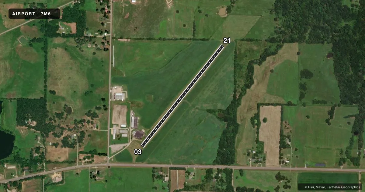
Runways & pattern
Full pagePattern entry · RWY 03
LEFT TRAFFICRunway end performance
| End | TORA | TODA | ASDA | LDA | VGSI | Approach lights | Obstruction |
|---|---|---|---|---|---|---|---|
| 03 | — | — | — | — | — | — | 15', road, 450' from thr, 0' R of cntrln, slope 16 |
| 21 | — | — | — | — | PAPI 2-box left(3°) | — | 30', tree, 350' from thr, 270' R of cntrln, slope 5 |
Declared distances in feet. TORA = takeoff run available, TODA = takeoff distance, ASDA = accelerate-stop, LDA = landing distance.
Airport sketch
Runways drawn to scale from FAA survey coordinates, rendered over satellite imagery. Not for navigation.
Approaches & charts
Services on the field
Fuel grades, oxygen, maintenance, ramp storage and lighting — as declared to the FAA by the airport operator.
Fuel & services
- Fuel
- Not available
- Other services
- AGRI,AMB
Ramp & ground
- Transient storage
- Tie-down
- Hangar
- Landing fee
- No fee published
- Lighting schedule
- SEE RMK
- Beacon schedule
- SS-SR
- Beacon
- White / Green (civil land)(WG)
- Wind indicator
- Lighted
- Segmented circle
- No
Fuel & FBOs
Cheapest 100LL and Jet A on the field and nearby. Always confirm with the FBO before taxi.
Airport notes
Surface conditions, obstructions, local procedures, lighting outages and other notes published with each FAA cycle.
General notes
- AGRICULTURE OPS FEB-OCT BLO 500 FT AGL.
- FOR CD CTC MEMPHIS ARTCC AT 901-368-8453/8449.
Lighting notes
- ACTVT MIRL RWY 03/21 - CTAF
Runway surface & condition
- 03/21MIRL OTS INDEFLY.
Approach & departure obstructions
- 21PAPI OTS INDEFLY.
VFR map & nearby airports
VFR sectional. Tap any ICAO chip to open that airport.
Key facts · 7M6
Answer card- ICAO
- 7M6
- Name
- PARIS MUNI
- Location
- PARIS /SUBIACO/, ARKANSAS
- Elevation
- 430 ft MSL
- Traffic pattern altitude
- 1,430 ft MSL (1,000 AGL)
- Control tower
- Non-towered (use CTAF)
- Total runways
- 1
- Longest runway
- 03/21 · 2,710 ft
- Published ILS approaches
- 0
- Published frequencies
- 1
- Magnetic variation
- 5°
- Current flight rules
- VFR
- Current wind
- 070° at 9 kt
- Favored runway now
- RWY 03
Paris Muni sits in Paris /Subiaco/, Arkansas. The field elevation is 430 ft MSL. It has one runway. Runway 03/21 is 2,710 ft long and asphalt. There is no control tower. CTAF is 122.9.
No ILS approaches are published here. The pattern altitude is not published, so use the standard 1,000 ft AGL for light piston traffic unless the current Chart Supplement says otherwise. The published remarks matter here. The PAPI on runway 21 is out of service indefinitely. Medium intensity runway lights on runway 03/21 are also out of service indefinitely. The lights are activated by CTAF.
There are no on-field FBOs listed in the facts, so verify fuel and service availability before you go. Agriculture operations occur from February through October below 500 ft AGL. That is worth keeping in mind on arrival and departure, especially at low altitude near the field. For clearance delivery, contact Memphis ARTCC at 901-368-8453 or 901-368-8449. Check the current FAA Chart Supplement for any changes before flight.