METAR & TAF 32A
32A does not publish a METAR.
Showing the nearest reporting station: KRUE (RUSSELLVILLE RGNL) · 19.5 NM away. Conditions at 32A may differ.
METAR · KRUE
Observed 11:53Z
KRUE 271153Z AUTO 00000KT 10SM CLR 24/23 A2995 RMK AO2 SLP132 T02440233 10272 20244 53013
- Wind
- 000° @ 0 kt
- Visibility
- 10 SM
- Temp / Dew
- 24°C / 23°C
- Altimeter
- 29.95 inHg
- Clouds
- CLR
- Density alt
- 1,530 ft
- Ceiling
- Unlimited
- Rules
- VFR
Airport info & contacts
Manager on record, flight service, ARTCC, attendance schedule and pattern altitude — published by the FAA and refreshed every 28 days.
Location
- From city
- 3 NM NW
- VFR sectional
- MEMPHIS
- ARTCC
- ZME · MEMPHIS
- NOTAM facility
- JBR (NOTAM-D)
Airport manager
- Name
- HEATH TATE
- Phone
- 479-495-0722
- Address
- PO BOX 69, DANVILLE AR 72833
Flight service · Hours
- FSS JBR
- JONESBORO1-800-WX-BRIEF
- Attendance
- Unattended
Frequencies
Tap any row to copy the frequency to your clipboard.
Runways & pattern
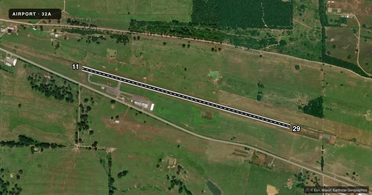
Full pagePattern entry · RWY 11
LEFT TRAFFICAirport sketch
Runways drawn to scale from FAA survey coordinates, rendered over satellite imagery. Not for navigation.
Approaches & charts
Services on the field
Fuel grades, oxygen, maintenance, ramp storage and lighting — as declared to the FAA by the airport operator.
Fuel & services
- Fuel
- 100LL
- Airframe repair
- Not available
- Power plant repair
- Not available
- Other services
- AGRI
Ramp & ground
- Transient storage
- Tie-down
- Hangar
- Lighting schedule
- SEE RMK
- Beacon schedule
- SS-SR
- Beacon
- White / Green (civil land)(WG)
- Wind indicator
- Lighted
- Segmented circle
- No
Fuel & FBOs
Cheapest 100LL and Jet A on the field and nearby. Always confirm with the FBO before taxi.
Airport notes
Surface conditions, obstructions, local procedures, lighting outages and other notes published with each FAA cycle.
General notes
- FOR CD CTC MEMPHIS ARTCC AT 901-368-8453/8449.
Lighting notes
- ACTVT MIRL RWY 11/29 - CTAF.
Fuel notes
- 100LLSELF SERVE FUEL AVBL 24 HRS WITH CREDIT CARD OTS INDEFLY.
Other notes
- 1FOR SVC CALL YELL COUNTY SHERIFF 501-495-4881.
VFR map & nearby airports
VFR sectional. Tap any ICAO chip to open that airport.
Key facts · 32A
Answer card- ICAO
- 32A
- Name
- DANVILLE MUNI
- Location
- DANVILLE, ARKANSAS
- Elevation
- 392.5 ft MSL
- Traffic pattern altitude
- 1,392.5 ft MSL (1,000 AGL)
- Control tower
- Non-towered (use CTAF)
- Total runways
- 1
- Longest runway
- 11/29 · 4,466 ft
- Published ILS approaches
- 0
- Published frequencies
- 1
- Magnetic variation
- 1°
- Current flight rules
- VFR
- Current wind
- 000° at 0 kt
- Favored runway now
- –
Danville Muni (32A) sits in Danville, Arkansas. The field elevation is 392.5 ft MSL. It has one runway, 11/29, which is 4,466 ft long. There is no control tower. CTAF is 122.9. No ILS approaches are published here, so plan with current charts and weather in mind if you are arriving IFR.
The published pattern altitude is not listed, so use the standard 1,000 ft AGL pattern unless current local guidance says otherwise. The runway lights on 11/29 are medium intensity and are activated by the CTAF. That is useful for a night arrival. Self-serve 100LL is available 24 hours with credit card use outside tower hours. There are no on-field FBOs listed in the facts, so call ahead if you need service before arrival.
For clearance delivery, contact Memphis ARTCC at the numbers in the Chart Supplement. For service on the ground, the published remarks point to the Yell County Sheriff. This is a small non-towered field. Expect self-announce traffic. Keep a close scan in the pattern. The runway length is workable for light piston aircraft. Still, verify performance for your load, density altitude and runway condition before you go.