METAR & TAF 4M2
4M2 does not publish a METAR.
Showing the nearest reporting station: KFSM (FORT SMITH RGNL) · 27.1 NM away. Conditions at 4M2 may differ.
METAR · KFSM
Observed 11:53Z
KFSM 271153Z 00000KT 10SM CLR 27/24 A2994 RMK AO2 SLP133 T02670239 10300 20261 53012
- Wind
- 000° @ 0 kt
- Visibility
- 10 SM
- Temp / Dew
- 27°C / 24°C
- Altimeter
- 29.94 inHg
- Clouds
- CLR
- Density alt
- 1,995 ft
- Ceiling
- Unlimited
- Rules
- VFR
Airport info & contacts
Manager on record, flight service, ARTCC, attendance schedule and pattern altitude — published by the FAA and refreshed every 28 days.
Location
- From city
- 3 NM E
- VFR sectional
- MEMPHIS
- ARTCC
- ZME · MEMPHIS
- NOTAM facility
- JBR (NOTAM-D)
Airport manager
- Name
- BILL TUCKER
- Phone
- 479-518-5890
- Address
- PO BOX 912, BOONEVILLE AR 72927
Flight service · Hours
- FSS JBR
- JONESBORO1-800-WX-BRIEF
- Attendance
- MON-FRI · 0800-1700
Frequencies
Tap any row to copy the frequency to your clipboard.
Runways & pattern
Full pagePattern entry · RWY 09
LEFT TRAFFICRunway end performance
| End | TORA | TODA | ASDA | LDA | VGSI | Approach lights | Obstruction |
|---|---|---|---|---|---|---|---|
| 09 | — | — | — | — | — | — | 50', trees, 560' from thr, 175' R of cntrln, slope 7 |
| 27 | — | — | — | — | — | — | 40', trees, 950' from thr, 0' R of cntrln, slope 18 |
Declared distances in feet. TORA = takeoff run available, TODA = takeoff distance, ASDA = accelerate-stop, LDA = landing distance.
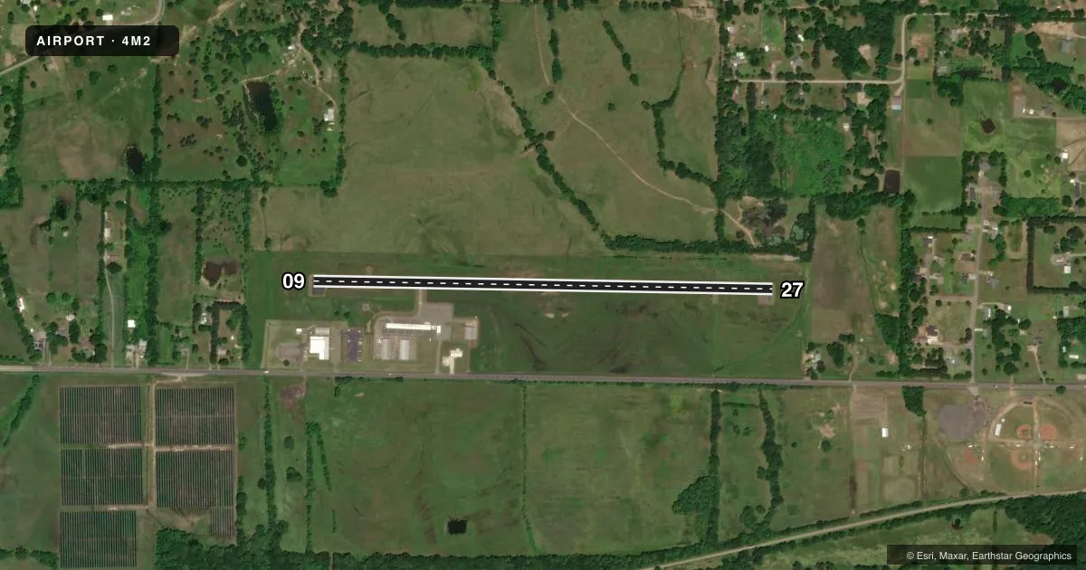
Airport sketch
Runways drawn to scale from FAA survey coordinates, rendered over satellite imagery. Not for navigation.
Approaches & charts
Services on the field
Fuel grades, oxygen, maintenance, ramp storage and lighting — as declared to the FAA by the airport operator.
Fuel & services
- Fuel
- 100LL
- Oxygen (bottled)
- Not available
- Oxygen (bulk)
- Not available
- Airframe repair
- Major
- Power plant repair
- Major
- Other services
- INSTR
Ramp & ground
- Transient storage
- Tie-down
- Hangar
- Landing fee
- No fee published
- Customs
- Not available
- Lighting schedule
- SEE RMK
- Beacon schedule
- SS-SR
- Beacon
- White / Green (civil land)(WG)
- Wind indicator
- Yes
- Segmented circle
- Yes
Fuel & FBOs
Cheapest 100LL and Jet A on the field and nearby. Always confirm with the FBO before taxi.
Airport notes
Surface conditions, obstructions, local procedures, lighting outages and other notes published with each FAA cycle.
General notes
- FOR CD CTC RAZORBACK APCH AT 479-649-2416, WHEN APCH CLSD CTC MEMPHIS ARTCC AT 901-368-8453/8449.
Lighting notes
- ACTVT MIRL RY 09/27 - CTAF.
Fuel notes
- 100LLSELF-SERVE FUEL AVBL 24 HRS WITH CREDIT CARD.
VFR map & nearby airports
VFR sectional. Tap any ICAO chip to open that airport.
Key facts · 4M2
Answer card- ICAO
- 4M2
- Name
- BOONEVILLE MUNI
- Location
- BOONEVILLE, ARKANSAS
- Elevation
- 467.8 ft MSL
- Traffic pattern altitude
- 1,467.8 ft MSL (1,000 AGL)
- Control tower
- Non-towered (use CTAF)
- Total runways
- 1
- Longest runway
- 09/27 · 3,254 ft
- Published ILS approaches
- 0
- Published frequencies
- 2
- Magnetic variation
- 5°
- Current flight rules
- VFR
- Current wind
- 000° at 0 kt
- Favored runway now
- –
Booneville Muni sits in Booneville, Arkansas. Field elevation is 467.8 ft MSL. The airport has one runway. Runway 09/27 is 3,254 ft long with an asphalt surface. That is the longest runway here.
This is an untowered field. CTAF and UNICOM are both 122.8. No ILS approaches are published. Pattern altitude is not published, so use the standard 1,000 ft AGL for light piston operations unless the current Chart Supplement says otherwise. The runway lights on 09/27 are medium intensity. They are activated by the CTAF.
Booneville Municipal Airport is on the field. It carries AVGAS 100LL. Self-serve fuel is available 24 hours with credit card. For clearance delivery, contact Razorback Approach at 479-649-2416. When approach is closed, contact Memphis ARTCC at 901-368-8453 or 901-368-8449.
For a first-time arrival, the main items are straightforward. Plan for an untowered pattern. Verify the current Chart Supplement for any published noise or curfew restrictions before flying in. The field sits in western Arkansas, so check weather and terrain carefully on the day of flight. Use the published lighting activation method if you plan a night arrival.