METAR & TAF M27
M27 does not publish a METAR.
Showing the nearest reporting station: KMEZ (MENA INTERMOUNTAIN MUNI) · 20.4 NM away. Conditions at M27 may differ.
METAR · KMEZ
Observed 05:35Z
KMEZ 270535Z AUTO 00000KT 10SM CLR 29/21 A2997 RMK AO2 T02850213
- Wind
- 000° @ 0 kt
- Visibility
- 10 SM
- Temp / Dew
- 29°C / 21°C
- Altimeter
- 29.97 inHg
- Clouds
- CLR
- Density alt
- 2,492 ft
- Ceiling
- Unlimited
- Rules
- VFR
Airport info & contacts
Manager on record, flight service, ARTCC, attendance schedule and pattern altitude — published by the FAA and refreshed every 28 days.
Location
- From city
- 2 NM SW
- VFR sectional
- MEMPHIS
- ARTCC
- ZME · MEMPHIS
- NOTAM facility
- JBR (NOTAM-D)
Airport manager
- Name
- DAVID MILLARD
- Phone
- 479-637-3181
- Address
- PO BOX 310, WALDRON AR 72958
Flight service · Hours
- FSS JBR
- JONESBORO1-800-WX-BRIEF
- Attendance
- Unattended
Frequencies
Tap any row to copy the frequency to your clipboard.
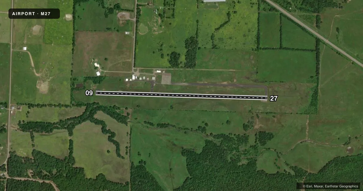
Runways & pattern
Full pagePattern entry · RWY 09
LEFT TRAFFICRunway end performance
| End | TORA | TODA | ASDA | LDA | VGSI | Approach lights | Obstruction |
|---|---|---|---|---|---|---|---|
| 09 | — | — | — | — | — | — | 25', trees, 350' from thr, 30' R of cntrln, slope 6 |
| 27 | — | — | — | — | — | — | 17', tree, 1100' from thr, 285' R of cntrln, slope 50 |
Declared distances in feet. TORA = takeoff run available, TODA = takeoff distance, ASDA = accelerate-stop, LDA = landing distance.
Airport sketch
Runways drawn to scale from FAA survey coordinates, rendered over satellite imagery. Not for navigation.
Approaches & charts
Services on the field
Fuel grades, oxygen, maintenance, ramp storage and lighting — as declared to the FAA by the airport operator.
Fuel & services
- Fuel
- Not available
Ramp & ground
- Transient storage
- Tie-down
- Landing fee
- No fee published
- Customs
- Not available
- Lighting schedule
- SEE RMK
- Beacon schedule
- SS-SR
- Beacon
- White / Green (civil land)(WG)
- Wind indicator
- Yes
- Segmented circle
- Yes
Fuel & FBOs
Cheapest 100LL and Jet A on the field and nearby. Always confirm with the FBO before taxi.
Airport notes
Surface conditions, obstructions, local procedures, lighting outages and other notes published with each FAA cycle.
General notes
- DEER ON & INVOF ARPT
- FOR CD CTC RAZORBACK APCH AT 479-649-2416, WHEN APCH CLSD CTC MEMPHIS ARTCC AT 901-368-8453/8449.
Lighting notes
- ACTVT MIRL RWY 09/27 - CTAF.
Approach & departure obstructions
- 0915 FT TREE 60 FT FROM RWY END AND 60 FT R; 20 FT TREE 80 FT FROM RWY END AND 30 FT L.
Other notes
- MANAGERMAYOR OF WALDRON.
VFR map & nearby airports
VFR sectional. Tap any ICAO chip to open that airport.
Key facts · M27
Answer card- ICAO
- M27
- Name
- WALDRON MUNI
- Location
- WALDRON, ARKANSAS
- Elevation
- 705 ft MSL
- Traffic pattern altitude
- 1,705 ft MSL (1,000 AGL)
- Control tower
- Non-towered (use CTAF)
- Total runways
- 1
- Longest runway
- 09/27 · 3,650 ft
- Published ILS approaches
- 0
- Published frequencies
- 1
- Magnetic variation
- 5°
- Current flight rules
- VFR
- Current wind
- 000° at 0 kt
- Favored runway now
- –
Waldron Muni sits in Waldron, Arkansas. The field elevation is 705 ft MSL. It has one runway, 09/27, which is 3,650 ft long. There is no control tower. CTAF is 122.9. No ILS approaches are published.
The published pattern altitude is not listed. Use standard 1,000 ft AGL for light piston operations unless the current Chart Supplement says otherwise. That puts you at about 1,705 ft MSL here. The runway lights on 09/27 are medium intensity. They are activated by CTAF. That is useful after sunset, but you should still verify the lighting procedure before departure.
There are no on-field FBOs listed in the facts. Contact the airport operator directly or call the field on CTAF for current fuel and service availability. The published remarks also call out deer on and near the airport. That matters on taxi, takeoff and landing. There are also trees near the departure end of runway 09. One is 15 ft tall, 60 ft from the runway end and 60 ft right of centerline. Another is 20 ft tall, 80 ft from the runway end and 30 ft left of centerline. For clearance delivery, the published contact is Razorback Approach. If approach is closed, contact Memphis ARTCC.