METAR & TAF 7M5
7M5 does not publish a METAR.
Showing the nearest reporting station: KFSM (FORT SMITH RGNL) · 27.8 NM away. Conditions at 7M5 may differ.
METAR · KFSM
Observed 12:53Z
KFSM 271253Z 05003KT 10SM CLR 29/25 A2995 RMK AO2 SLP136 T02890250
- Wind
- 050° @ 3 kt
- Visibility
- 10 SM
- Temp / Dew
- 29°C / 25°C
- Altimeter
- 29.95 inHg
- Clouds
- CLR
- Density alt
- 2,446 ft
- Ceiling
- Unlimited
- Rules
- VFR
Airport info & contacts
Manager on record, flight service, ARTCC, attendance schedule and pattern altitude — published by the FAA and refreshed every 28 days.
Location
- From city
- 2 NM NW
- VFR sectional
- MEMPHIS
- ARTCC
- ZME · MEMPHIS
- NOTAM facility
- JBR (NOTAM-D)
Airport manager
- Name
- MIKE PRUETT
- Phone
- 479-751-7225
- Address
- P.O. BOX 262, OZARK AR 72949
Flight service · Hours
- FSS JBR
- JONESBORO1-800-WX-BRIEF
- Attendance
- UNATTNDD
Frequencies
Tap any row to copy the frequency to your clipboard.
Runways & pattern
Full pagePattern entry · RWY 04
LEFT TRAFFICRunway end performance
| End | TORA | TODA | ASDA | LDA | VGSI | Approach lights | Obstruction |
|---|---|---|---|---|---|---|---|
| 04 | — | — | — | — | PAPI 2-box left(3°) | — | 5', bldg, 250' from thr, 0' R of cntrln, slope 10 |
| 22 | — | — | — | — | PAPI 2-box left(4°) | — | 35', tree, 800' from thr, 350' R of cntrln, slope 17 |
Declared distances in feet. TORA = takeoff run available, TODA = takeoff distance, ASDA = accelerate-stop, LDA = landing distance.
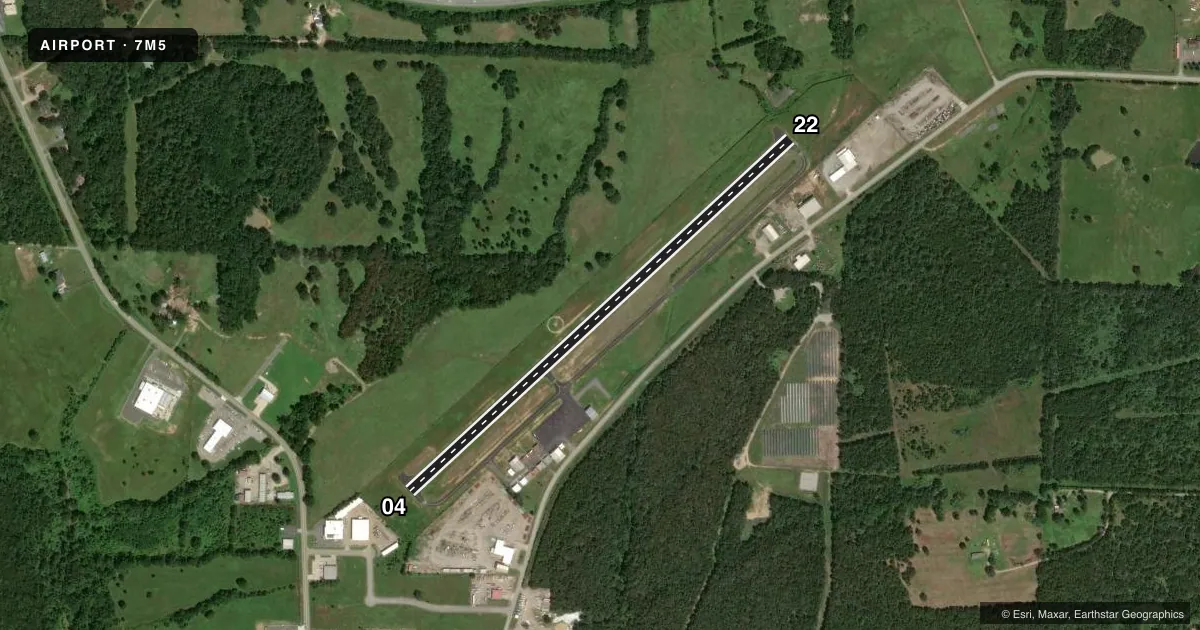
Airport sketch
Runways drawn to scale from FAA survey coordinates, rendered over satellite imagery. Not for navigation.
Approaches & charts
Services on the field
Fuel grades, oxygen, maintenance, ramp storage and lighting — as declared to the FAA by the airport operator.
Fuel & services
- Fuel
- 100LL
- Oxygen (bottled)
- Not available
- Oxygen (bulk)
- Not available
Ramp & ground
- Transient storage
- Tie-down
- Landing fee
- No fee published
- Customs
- Not available
- Lighting schedule
- SEE RMK
- Beacon schedule
- SS-SR
- Beacon
- White / Green (civil land)(WG)
- Wind indicator
- Lighted
- Segmented circle
- Yes
Fuel & FBOs
Cheapest 100LL and Jet A on the field and nearby. Always confirm with the FBO before taxi.
Airport notes
Surface conditions, obstructions, local procedures, lighting outages and other notes published with each FAA cycle.
General notes
- USE EXTRM CTN, WILDLIFE MAY BE ON FLD.
- FOR CD CTC RAZORBACK APCH AT 479-649-2416, WHEN APCH CLSD CTC MEMPHIS ARTCC AT 901-368-8453/8449.
Lighting notes
- DUSK-DAWN. ACTVT MIRL RY 04/22, PAPI RYS 4 &22 - CTAF.
Fuel notes
- 100LLSELF SERVICE FUEL AVBL 24 HRS WITH CREDIT CARD.
Approach & departure obstructions
- 22RWY 22 PAPI UNUSBL BYD 2 DEG RIGHT OF CNTRLN. RWY 22 PAPI DOES NOT PRVD OBSTN CLNC BYD 4.0 NM FM THLD, UNUSBL BYD 4.0 NM.
Other notes
- THIS AIRPORT HAS BEEN SURVEYED BY THE NATIONAL GEODETIC SURVEY.
- OWNERCOUNTY JUDGE.
VFR map & nearby airports
VFR sectional. Tap any ICAO chip to open that airport.
Key facts · 7M5
Answer card- ICAO
- 7M5
- Name
- OZARK/FRANKLIN COUNTY
- Location
- OZARK, ARKANSAS
- Elevation
- 648 ft MSL
- Traffic pattern altitude
- 1,648 ft MSL (1,000 AGL)
- Control tower
- Non-towered (use CTAF)
- Total runways
- 1
- Longest runway
- 04/22 · 3,302 ft
- Published ILS approaches
- 0
- Published frequencies
- 4
- Magnetic variation
- 4°
- Current flight rules
- VFR
- Current wind
- 050° at 3 kt
- Favored runway now
- RWY 04
7M5 sits in Ozark, Arkansas. The field elevation is 648 ft MSL. It has one runway. Runway 04/22 is 3,302 ft long with asphalt pavement. The airport is not towered. CTAF and UNICOM are both 122.8. Razorback Approach handles clearance delivery and approach services when it is open.
No ILS approaches are published here. Pattern altitude is not published, so use the standard 1,000 ft AGL for light piston operations unless the current Chart Supplement says otherwise. The on-field FBO is Ozark-Franklin County Airport. It carries AVGAS 100LL. Self-serve fuel is available 24 hours with credit card.
A few remarks matter for planning. Runway 22 PAPI is unusable beyond 2 degrees right of centerline. It also does not provide obstruction clearance beyond 4 NM from the threshold. Lighting runs from dusk to dawn. Medium intensity runway lights on 04/22 and the PAPI are activated via CTAF. Wildlife may be on the field, so keep a sharp scan on taxi and final. For clearance delivery, call Razorback Approach at 479-649-2416. If approach is closed, contact Memphis ARTCC. This is a good field to brief carefully before arrival because the published notes affect both night ops and runway 22 guidance.