METAR & TAF KFYV
Current METAR
Observed 14:53Z
KFYV 271453Z 22010KT 10SM CLR 31/21 A2999 RMK AO2 SLP136 T03110211 50000
- Wind
- 220° @ 10 kt
- Visibility
- 10 SM
- Temp / Dew
- 31°C / 21°C
- Altimeter
- 29.99 inHg
- Clouds
- CLR
- Density alt
- 3,386 ft
- Ceiling
- Unlimited
- Rules
- VFR
Airport info & contacts
Manager on record, flight service, ARTCC, attendance schedule and pattern altitude — published by the FAA and refreshed every 28 days.
Location
- From city
- 3 NM S
- VFR sectional
- KANSAS CITY
- Pattern altitude
- 849 ft AGL · 2,101 ft MSL
- ARTCC
- ZME · MEMPHIS
- NOTAM facility
- FYV (NOTAM-D)
Airport manager
- Name
- JARED RABREN
- Phone
- (479) 718-7644
- Address
- 4500 S SCHOOL SUITE F, FAYETTEVILLE AR 72701
Flight service · Hours
- FSS JBR
- JONESBORO1-800-WX-BRIEF
- Attendance
- MON-FRI · 0600-2200
- SAT-SUN · 0800-2000
Frequencies
Tap any row to copy the frequency to your clipboard.
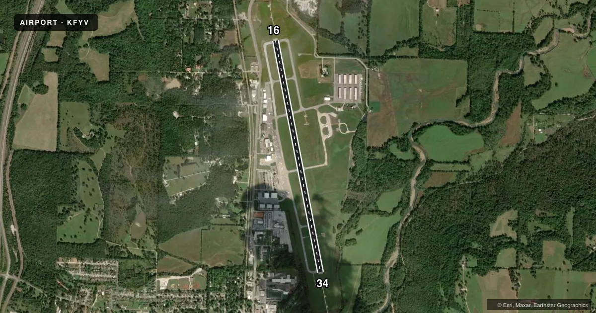
Runways & pattern
Full pagePattern entry · RWY 16
LEFT TRAFFICRunway end performance
| End | TORA | TODA | ASDA | LDA | VGSI | Approach lights | Obstruction |
|---|---|---|---|---|---|---|---|
| 16 | 6,005' | 6,005' | 6,005' | 6,005' | PAPI 4-box left(3°) | ODALS | — |
| 34 | 6,005' | 6,005' | 6,005' | 6,005' | PAPI 4-box left(3.5°) | ODALS | 263', tree, 5585' from thr, 958' R of cntrln, slope 20 |
Declared distances in feet. TORA = takeoff run available, TODA = takeoff distance, ASDA = accelerate-stop, LDA = landing distance.
Airport sketch
Runways drawn to scale from FAA survey coordinates, rendered over satellite imagery. Not for navigation.
Approaches & charts
ILS · 2
Services on the field
Fuel grades, oxygen, maintenance, ramp storage and lighting — as declared to the FAA by the airport operator.
Fuel & services
- Fuel
- 100LLA
- Oxygen (bulk)
- Not available
- Airframe repair
- Minor
- Power plant repair
- Minor
- Other services
- AFRT,AVNCS,CARGO,CHTR,INSTR
Ramp & ground
- Transient storage
- Tie-down
- Hangar
- Landing fee
- No fee published
- Customs
- Not available
- Lighting schedule
- SEE RMK
- Beacon schedule
- SS-SR
- Beacon
- White / Green (civil land)(WG)
- Wind indicator
- Lighted
- Segmented circle
- No
Fuel & FBOs
Cheapest 100LL and Jet A on the field and nearby. Always confirm with the FBO before taxi.
Airport notes
Surface conditions, obstructions, local procedures, lighting outages and other notes published with each FAA cycle.
General notes
- DEER ON & INVOF ARPT.
- FOR CD CTC MEMPHIS ARTCC AT 901-368-8453/8449.
Lighting notes
- WHEN ATCT CLSD MIRL RWY 16/34 PRESET MED INTST. ACTVT ODALS RWY 16 & 34; PAPI RWY 34 - CTAF.
Fuel notes
- 100LLFOR FUEL AFTER HRS CALL 479-443-4343; FEE CHARGED. SELF SERVICE AVBL 24 HRS.
Runway surface & condition
- 16/34PCR VALUE: 530/F/C/W/T
Other notes
- 24 HR PPR FOR ACR OPNS WITH MORE THAN 30 PSGR SEATS CALL AMGR 479-718-7642 & FAX FBO 479-718-7646.
- MANAGERDIRECTOR, AVIATION.
VFR map & nearby airports
VFR sectional. Tap any ICAO chip to open that airport.
Key facts · KFYV
Answer card- ICAO
- KFYV
- Name
- DRAKE FLD
- Location
- FAYETTEVILLE, ARKANSAS
- Elevation
- 1,252 ft MSL
- Traffic pattern altitude
- 2,101 ft MSL (849 AGL)
- Control tower
- Towered · 0600-2200
- Total runways
- 1
- Longest runway
- 16/34 · 6,005 ft
- Published ILS approaches
- 2
- Published frequencies
- 8
- Magnetic variation
- 2°
- Current flight rules
- VFR
- Current wind
- 220° at 10 kt
- Favored runway now
- RWY 16
DRAKE FLD sits in Fayetteville, Arkansas. Field elevation is 1,252 ft MSL. The airport has one runway. Runway 16/34 is 6,005 ft long with asphalt pavement. The tower is open daily from 0600 to 2200. Two ILS approaches are published, one for runway 16 and one for runway 34. Pattern altitude is 849 ft AGL, which is 2,101 ft MSL.
Fayetteville Aviation Services is on the field. It carries 100LL and Jet A Prist. Self-serve 100LL is available 24 hours. After-hours fuel support is available by phone. Deer are reported on and near the airport, so keep a sharp scan on taxi, takeoff and landing. The runway lighting setup also matters here. When the tower is closed, the medium intensity runway lights on 16/34 are preset. The approach lighting system is available on both ends. The PAPI for runway 34 is controlled by CTAF.
This is a towered field with published approach services and a single long runway. For clearance delivery, contact Memphis ARTCC if needed. Pilots should also note the pavement classification rating on 16/34 and verify any aircraft-specific limits before arrival.