METAR & TAF 5M5
5M5 does not publish a METAR.
Showing the nearest reporting station: KXNA (NORTHWEST ARKANSAS NTL) · 7.6 NM away. Conditions at 5M5 may differ.
METAR · KXNA
Observed 17:53Z
KXNA 271753Z 21007G16KT 10SM CLR 35/20 A2996 RMK AO2 SLP125 T03500200 10350 20239 58008
- Wind
- 210° @ 7G16 kt
- Visibility
- 10 SM
- Temp / Dew
- 35°C / 20°C
- Altimeter
- 29.96 inHg
- Clouds
- CLR
- Density alt
- 3,811 ft
- Ceiling
- Unlimited
- Rules
- VFR
Airport info & contacts
Manager on record, flight service, ARTCC, attendance schedule and pattern altitude — published by the FAA and refreshed every 28 days.
Location
- From city
- 2 NM NE
- VFR sectional
- KANSAS CITY
- ARTCC
- ZME · MEMPHIS
- NOTAM facility
- JBR (NOTAM-D)
Airport manager
- Name
- LANCE DIXON
- Phone
- 479-220-5047
- Address
- 18820 CRYSTAL LAKE ROAD, DECATUR AR 72722
Flight service · Hours
- FSS JBR
- JONESBORO1-800-WX-BRIEF
- Attendance
- Unattended
Frequencies
Tap any row to copy the frequency to your clipboard.
Runways & pattern
Full pagePattern entry · RWY 13
LEFT TRAFFICRunway end performance
| End | TORA | TODA | ASDA | LDA | VGSI | Approach lights | Obstruction |
|---|---|---|---|---|---|---|---|
| 13 | — | — | — | — | — | — | 55', trees, 450' from thr, 185' R of cntrln, slope 4 |
| 31 | — | — | — | — | — | — | 41', trees, 300' from thr, 125' R of cntrln, slope 2 |
Declared distances in feet. TORA = takeoff run available, TODA = takeoff distance, ASDA = accelerate-stop, LDA = landing distance.
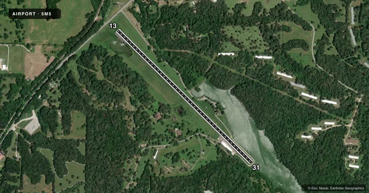
Airport sketch
Runways drawn to scale from FAA survey coordinates, rendered over satellite imagery. Not for navigation.
Approaches & charts
Services on the field
Fuel grades, oxygen, maintenance, ramp storage and lighting — as declared to the FAA by the airport operator.
Fuel & services
- Fuel
- Not available
- Oxygen (bulk)
- Not available
- Airframe repair
- Major
- Power plant repair
- Major
- Other services
- INSTR
Ramp & ground
- Transient storage
- Tie-down
- Hangar
- Landing fee
- No fee published
- Customs
- Not available
- Lighting schedule
- SS-SR
- Wind indicator
- Lighted
- Segmented circle
- No
Fuel & FBOs
Cheapest 100LL and Jet A on the field and nearby. Always confirm with the FBO before taxi.
Airport notes
Surface conditions, obstructions, local procedures, lighting outages and other notes published with each FAA cycle.
General notes
- BE ALERT FOR +176 FT TWR APRXLY 1300 FT N OF RY 13.
- DEER & GEESE ON & INVOF ARPT.
- FOR CD CTC RAZORBACK APCH 479-649-2416, WHEN APCH CLSD CTC MEMPHIS ARTCC AT 901-368-8453/8449.
Approach & departure obstructions
- 13NSTD THLD MARKINGS DUE TO SIZE.
- 31NSTD THLD MARKNIGS DUE TO SIZE.
Other notes
- PRE DATES THE ACT.
VFR map & nearby airports
VFR sectional. Tap any ICAO chip to open that airport.
Key facts · 5M5
Answer card- ICAO
- 5M5
- Name
- CRYSTAL LAKE
- Location
- DECATUR, ARKANSAS
- Elevation
- 1,177.8 ft MSL
- Traffic pattern altitude
- 2,177.8 ft MSL (1,000 AGL)
- Control tower
- Non-towered (use CTAF)
- Total runways
- 1
- Longest runway
- 13/31 · 3,863 ft
- Published ILS approaches
- 0
- Published frequencies
- 5
- Magnetic variation
- 3°
- Current flight rules
- VFR
- Current wind
- 210° at 7 kt
- Favored runway now
- RWY 13
Crystal Lake Airport sits in Decatur, Arkansas. Field elevation is 1,177.8 ft MSL. The airport has one runway. Runway 13/31 is 3,863 ft long with an asphalt surface. No tower is published here, so plan for CTAF traffic and standard self-announced operations. Pattern altitude is not published. For light piston planning, use 1,000 ft AGL unless the current Chart Supplement says otherwise.
No ILS approaches are published at 5M5. That matters if you are planning an IFR arrival in lower weather. Check the current Chart Supplement and the airport operator for the latest approach and airport notes before you launch. Published remarks also flag nonstandard threshold markings on both runway ends. There is a 176-foot tower about 1,300 ft north of runway 13. Deer and geese are reported on and near the airport. Keep a sharp scan on climbout and final.
There are no on-field FBOs listed in the facts. Contact the airport operator directly before arrival, or call the field on CTAF or UNICOM for current FBO availability. Clearance delivery is handled through Razorback Approach when it is open. When approach is closed, contact Memphis ARTCC using the numbers in the Chart Supplement. This is a small field with a single runway. Plan your arrival with the terrain, wildlife and obstacle picture in mind.