METAR & TAF KROG
Current METAR
Observed 18:58Z
KROG 271858Z VRB06G15KT 10SM CLR 36/19 A2995 RMK AO2 SLP119 T03610194
- Wind
- VAR @ 6G15 kt
- Visibility
- 10 SM
- Temp / Dew
- 36°C / 19°C
- Altimeter
- 29.95 inHg
- Clouds
- CLR
- Density alt
- 4,168 ft
- Ceiling
- Unlimited
- Rules
- VFR
Airport info & contacts
Manager on record, flight service, ARTCC, attendance schedule and pattern altitude — published by the FAA and refreshed every 28 days.
Location
- From city
- 2 NM N
- VFR sectional
- KANSAS CITY
- Pattern altitude
- 999 ft AGL · 2,358 ft MSL
- ARTCC
- ZME · MEMPHIS
- NOTAM facility
- ROG (NOTAM-D)
Airport manager
- Name
- DAVID KRUTSCH
- Phone
- 479-631-1400
- Address
- #3 SOUTH AIRPORT DRIVE, ROGERS AR 72756
Flight service · Hours
- FSS JBR
- JONESBORO1-800-WX-BRIEF
- Attendance
- MON-FRI · 0400-2100
- SAT-SUN · 0700-1900
Frequencies
Tap any row to copy the frequency to your clipboard.
Runways & pattern
Full pagePattern entry · RWY 02
LEFT TRAFFICRunway end performance
| End | TORA | TODA | ASDA | LDA | VGSI | Approach lights | Obstruction |
|---|---|---|---|---|---|---|---|
| 02 | — | — | — | — | PAPI 4-box left(3°) | — | — |
| 20 | — | — | — | — | PAPI 4-box left(3°) | MALSR | — |
Declared distances in feet. TORA = takeoff run available, TODA = takeoff distance, ASDA = accelerate-stop, LDA = landing distance.
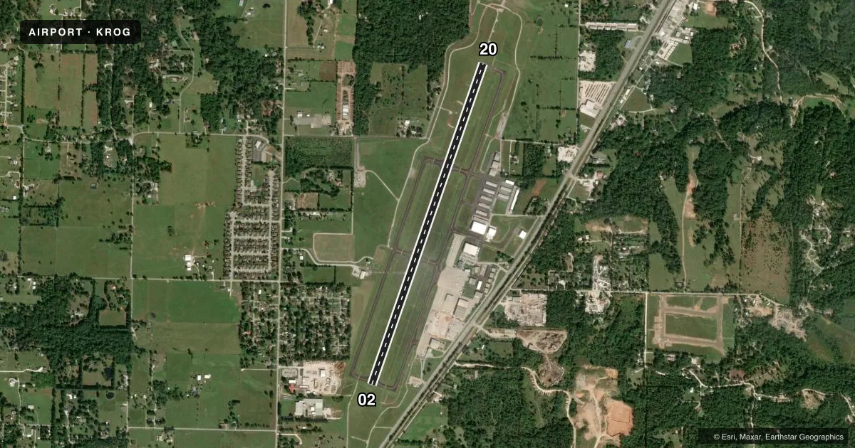
Airport sketch
Runways drawn to scale from FAA survey coordinates, rendered over satellite imagery. Not for navigation.
Approaches & charts
ILS · 1
Services on the field
Fuel grades, oxygen, maintenance, ramp storage and lighting — as declared to the FAA by the airport operator.
Fuel & services
- Fuel
- 100LLA
- Oxygen (bottled)
- High pressure
- Oxygen (bulk)
- Not available
- Airframe repair
- Major
- Power plant repair
- Major
- Other services
- AFRT,AMB,CHTR,INSTR,SALES
Ramp & ground
- Transient storage
- Tie-down
- Hangar
- Landing fee
- No fee published
- Customs
- Not available
- Lighting schedule
- SEE RMK
- Beacon schedule
- SS-SR
- Beacon
- White / Green (civil land)(WG)
- Wind indicator
- Lighted
- Segmented circle
- Yes
Fuel & FBOs
Cheapest 100LL and Jet A on the field and nearby. Always confirm with the FBO before taxi.
Airport notes
Surface conditions, obstructions, local procedures, lighting outages and other notes published with each FAA cycle.
General notes
- ARFF AVBL UPON REQUEST.
- RY 20 DESIGNATED CALM WIND RY.
- BIRD ACTIVITY ON & INVOF ARPT.
- DEER AND COYOTE ON & INVOF ARPT.
- FOR CD WHEN UNA VIA FREQ CTC RAZORBACK APCH 479-649-2416, WHEN APCH CLSD CTC MEMPHIS ARTCC AT 901-368-8453/8449.
Lighting notes
- WHEN ATCT CLSD ACTVT HIRL RY 02/20, REIL RY 02, TWY LGTS & MALSR RY 20, PAPI RY 02&20- CTAF.
Fuel notes
- 100LLFOR FUEL AFT HRS CALL 479-636-9400; FEE CHARGED.
VFR map & nearby airports
VFR sectional. Tap any ICAO chip to open that airport.
Key facts · KROG
Answer card- ICAO
- KROG
- Name
- ROGERS EXEC - CARTER FLD
- Location
- ROGERS, ARKANSAS
- Elevation
- 1,358.8 ft MSL
- Traffic pattern altitude
- 2,357.8 ft MSL (999 AGL)
- Control tower
- Towered · 0530-1930 MON-FRI; 0800-1900 SAT-SUN
- Total runways
- 1
- Longest runway
- 02/20 · 6,011 ft
- Published ILS approaches
- 1
- Published frequencies
- 7
- Magnetic variation
- 1°
- Current flight rules
- VFR
- Current wind
- 000° at 6 kt
- Favored runway now
- RWY 02
Rogers Exec - Carter Fld sits in Rogers, Arkansas. Field elevation is 1,358.8 ft MSL. The airport has one runway, 02/20, which is 6,011 ft long. The tower is open 0530-1930 Monday through Friday. Weekend hours are 0800-1900. Runway 20 is the calm wind runway. The field has one ILS approach. It serves runway 20.
Pattern altitude is 999 ft AGL. That puts the traffic pattern at 2,357.8 ft MSL. Beaver Lake Aviation is on the field. It carries 100LL, Jet A and Jet A Prist. If you need fuel after hours, call the FBO. A fee is charged.
This is a controlled airport with published approach and departure frequencies for Razorback Approach. If approach is closed, the Chart Supplement says to contact Memphis ARTCC for clearance help. Deer, coyote and bird activity are published concerns in the airport area. Aircraft rescue and fire fighting is available on request. When the tower is closed, runway and taxiway lighting is activated by CTAF. The airport sits at a higher elevation than many lowland fields in the region. Plan for performance with that in mind.