METAR & TAF 4M1
4M1 does not publish a METAR.
Showing the nearest reporting station: KFWB (BRANSON WEST MUNI/EMERSON FLD) · 21.9 NM away. Conditions at 4M1 may differ.
METAR · KFWB
Observed 05:55Z
KFWB 270555Z AUTO 25004KT 7SM CLR 28/22 A2995 RMK AO2
- Wind
- 250° @ 4 kt
- Visibility
- 7 SM
- Temp / Dew
- 28°C / 22°C
- Altimeter
- 29.95 inHg
- Clouds
- CLR
- Density alt
- 3,018 ft
- Ceiling
- Unlimited
- Rules
- VFR
Airport info & contacts
Manager on record, flight service, ARTCC, attendance schedule and pattern altitude — published by the FAA and refreshed every 28 days.
Location
- From city
- 3 NM W
- VFR sectional
- KANSAS CITY
- ARTCC
- ZME · MEMPHIS
- NOTAM facility
- JBR (NOTAM-D)
Airport manager
- Name
- DAVE TEIGEN
- Phone
- 870-423-8393
- Address
- 518 COUNTY ROAD 308, BERRYVILLE AR 72616
Flight service · Hours
- FSS JBR
- JONESBORO1-800-WX-BRIEF
- Attendance
- TUE-SAT · 0800-1700
Frequencies
Tap any row to copy the frequency to your clipboard.
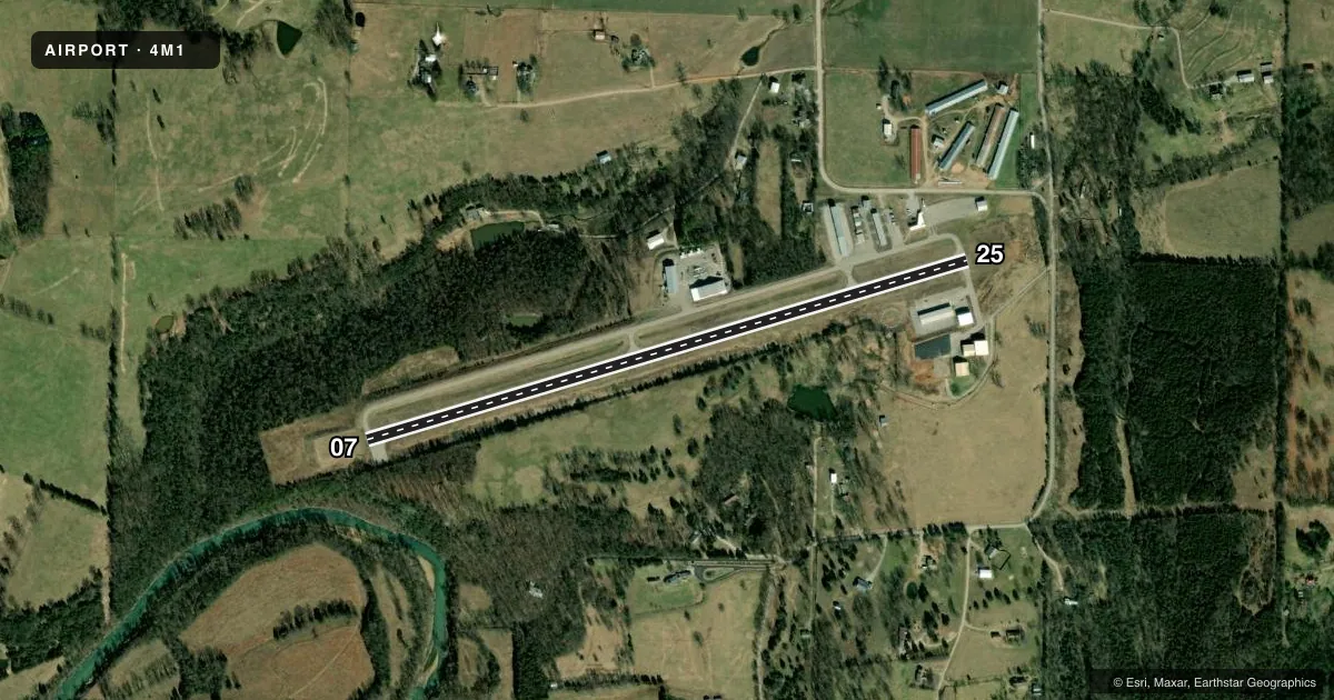
Runways & pattern
Full pagePattern entry · RWY 25
LEFT TRAFFICRunway end performance
| End | TORA | TODA | ASDA | LDA | VGSI | Approach lights | Obstruction |
|---|---|---|---|---|---|---|---|
| 07 | — | — | — | — | PAPI 2-box left(3°) | — | 30', trees, 1250' from thr, 175' R of cntrln, slope 35 |
| 25 | — | — | — | — | PAPI 2-box left(3°) | — | 17', trees, 580' from thr, 100' R of cntrln, slope 22 |
Declared distances in feet. TORA = takeoff run available, TODA = takeoff distance, ASDA = accelerate-stop, LDA = landing distance.
Airport sketch
Runways drawn to scale from FAA survey coordinates, rendered over satellite imagery. Not for navigation.
Approaches & charts
Services on the field
Fuel grades, oxygen, maintenance, ramp storage and lighting — as declared to the FAA by the airport operator.
Fuel & services
- Fuel
- 100LL
- Oxygen (bottled)
- Not available
- Oxygen (bulk)
- Not available
- Airframe repair
- Major
- Power plant repair
- Major
- Other services
- INSTR
Ramp & ground
- Transient storage
- Tie-down
- Hangar
- Landing fee
- No fee published
- Customs
- Not available
- Lighting schedule
- SEE RMK
- Beacon schedule
- SS-SR
- Beacon
- White / Green (civil land)(WG)
- Wind indicator
- Lighted
- Segmented circle
- Yes
Fuel & FBOs
Cheapest 100LL and Jet A on the field and nearby. Always confirm with the FBO before taxi.
Airport notes
Surface conditions, obstructions, local procedures, lighting outages and other notes published with each FAA cycle.
General notes
- NO LINE OF SIGHT BTN RY ENDS.
- ULTRALIGHT ACTIVITY ON & INVOF ARPT.
- DEER, TURKEY ON & INVOF ARPT.
- FOR CD CTC RAZORBACK APCH 479-649-2416, WHEN APCH CLSD CTC MEMPHIS ARTCC AT 901-368-8453/8449.
Lighting notes
- ACTVT REIL RWY 07 & 25; PAPI RWY 07 & 25, MIRL RWY 07/25; TWY LGTS - CTAF.
Fuel notes
- 100LLFUEL AVBL 24 HR SELF SERVE WITH CREDIT CARD.
VFR map & nearby airports
VFR sectional. Tap any ICAO chip to open that airport.
Key facts · 4M1
Answer card- ICAO
- 4M1
- Name
- CARROLL COUNTY
- Location
- BERRYVILLE, ARKANSAS
- Elevation
- 1,205.6 ft MSL
- Traffic pattern altitude
- 2,205.6 ft MSL (1,000 AGL)
- Control tower
- Non-towered (use CTAF)
- Total runways
- 1
- Longest runway
- 07/25 · 3,555 ft
- Published ILS approaches
- 0
- Published frequencies
- 3
- Magnetic variation
- 2°
- Current flight rules
- VFR
- Current wind
- 250° at 4 kt
- Favored runway now
- RWY 25
Carroll County Airport (4M1) sits in Berryville, Arkansas. Field elevation is 1,205.6 ft MSL. The airport has one runway. Runway 07/25 is 3,555 ft long with asphalt pavement. The field is not towered. Pattern altitude is not published, so use 1,000 ft AGL for light piston operations unless the current Chart Supplement says otherwise.
No ILS approaches are published here. For IFR work, plan around the published RAZORBACK approach frequencies. CTAF is 122.9. The on-field FBO is Carroll County Airport. It carries 100LL. Fuel is available 24 hours self-serve with credit card.
A few local details matter here. Deer and turkey are reported on and near the airport. Ultralight activity also occurs on and near the field. There is no line of sight between runway ends, so keep a close scan on taxi and runway movement. Runway end identifier lights are on both ends. PAPI is installed on runways 07 and 25. Medium intensity runway lights are on 07/25. Taxiway lights are controlled by CTAF. For clearance delivery, contact Razorback Approach. If approach is closed, use Memphis ARTCC. Check the current FAA Chart Supplement before departure for any updated operational notes.