METAR & TAF KBBG
Current METAR
Observed 17:45Z
KBBG 271745Z 17006KT 10SM CLR 35/20 A2997
- Wind
- 170° @ 6 kt
- Visibility
- 10 SM
- Temp / Dew
- 35°C / 20°C
- Altimeter
- 29.97 inHg
- Clouds
- CLR
- Density alt
- 3,952 ft
- Ceiling
- Unlimited
- Rules
- VFR
Airport info & contacts
Manager on record, flight service, ARTCC, attendance schedule and pattern altitude — published by the FAA and refreshed every 28 days.
Location
- From city
- 8 NM SSE
- VFR sectional
- KANSAS CITY
- ARTCC
- ZKC · KANSAS CITY
- NOTAM facility
- BBG (NOTAM-D)
Airport manager
- Name
- BRANSON AIRPORT, LLC- STANLEY FIELD
- Phone
- 417-334-7813
- Address
- 4000 BRANSON AIRPORT BLVD., HOLLISTER MO 65672
Flight service · Hours
- FSS COU
- COLUMBIA1-800-WX-BRIEF
- Attendance
- ALL
Frequencies
Tap any row to copy the frequency to your clipboard.
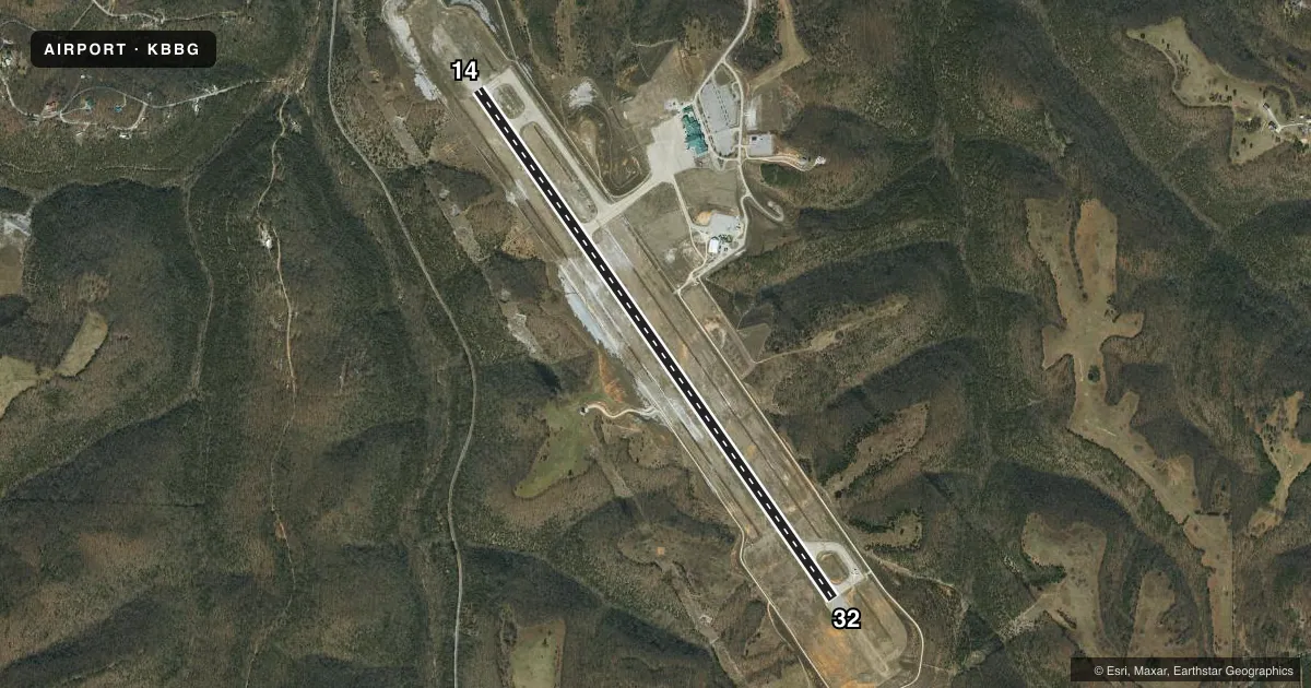
Runways & pattern
Full pagePattern entry · RWY 14
RIGHT TRAFFICRunway end performance
| End | TORA | TODA | ASDA | LDA | VGSI | Approach lights | Obstruction |
|---|---|---|---|---|---|---|---|
| 14 | 7,140' | 7,140' | 7,140' | 7,140' | PAPI 4-box left(3°) | — | — |
| 32 | 7,140' | 7,140' | 7,140' | 7,140' | PAPI 4-box left(3°) | MALSF | — |
Declared distances in feet. TORA = takeoff run available, TODA = takeoff distance, ASDA = accelerate-stop, LDA = landing distance.
Airport sketch
Runways drawn to scale from FAA survey coordinates, rendered over satellite imagery. Not for navigation.
Approaches & charts
ILS · 1
Services on the field
Fuel grades, oxygen, maintenance, ramp storage and lighting — as declared to the FAA by the airport operator.
Fuel & services
- Fuel
- 100LLAA+
Ramp & ground
- Transient storage
- Tie-down
- Hangar
- Lighting schedule
- SEE RMK
- Beacon schedule
- SS-SR
- Beacon
- White / Green (civil land)(WG)
- Wind indicator
- Yes
Fuel & FBOs
Cheapest 100LL and Jet A on the field and nearby. Always confirm with the FBO before taxi.
Airport notes
Surface conditions, obstructions, local procedures, lighting outages and other notes published with each FAA cycle.
General notes
- HILLS & UNEVEN TRRN INVOF; TRRN AVOIDANCE MAY ACTVT ON FNL.
- BIRDS INVOF ARPT.
Lighting notes
- WHEN ATCT CLSD: ACTVT MALSF RWY 32; REIL RWY 14; PAPI RWY 14 & 32; HIRL RWY 14/32 - CTAF.
Fuel notes
- 100LL100LL CREDIT CARD SELF SVC AVBL H24 AT GA APRON.
Runway surface & condition
- 14/32PCR VALUE: 510/R/C/W/T
Approach & departure obstructions
- 32CALM WIND RWY.
Other notes
- CLSD TO UNSKED ACR MORE THAN 30 PAX SEATS EXC 4 HR PPR - 417-334-8002. PPR ACR MORE THAN 15 MIN BFR OR AFT SKED ARR OR DEP - AMGR.
- OWNERLEASED TO BRANSON RGNL ARPT TRNSPN DVLPTMT DIST.
VFR map & nearby airports
VFR sectional. Tap any ICAO chip to open that airport.
Key facts · KBBG
Answer card- ICAO
- KBBG
- Name
- BRANSON
- Location
- BRANSON, MISSOURI
- Elevation
- 1,302 ft MSL
- Traffic pattern altitude
- 2,302 ft MSL (1,000 AGL)
- Control tower
- Towered · 0700-2100
- Total runways
- 1
- Longest runway
- 14/32 · 7,140 ft
- Published ILS approaches
- 1
- Published frequencies
- 8
- Magnetic variation
- 2°
- Current flight rules
- VFR
- Current wind
- 170° at 6 kt
- Favored runway now
- RWY 14
Branson Airport sits in Branson, Missouri. The field elevation is 1,302 ft MSL. It has one runway, 14/32. The longest runway is 7,140 ft of concrete. The tower is open daily from 0700 to 2100. Runway 32 has the ILS approach. Pattern altitude is not published in the facts, so verify the current Chart Supplement before you go. The airport is leased to the Branson Regional Airport Transportation Development District.
Branson Jet Center is on the field. It carries 100LL, Jet A and Jet A Prist. 100LL self-serve fuel is available 24 hours a day at the general aviation apron. The published remarks also note birds in the vicinity of the airport. Hills and uneven terrain are nearby. Terrain avoidance may activate on final approach. Plan your descent and approach path with that in mind.
Runway 32 is the calm wind runway. When the tower is closed, the lighting system is activated on CTAF. That matters for night arrivals or late departures. The airport also has a published restriction for unscheduled aircraft with more than 30 passenger seats. Aircraft more than 15 minutes early or late to a scheduled arrival or departure need prior permission from the airport manager. For anything operational that is not in the current facts, check the current FAA Chart Supplement or call the airport operator or FBO directly.