METAR & TAF KPLK
KPLK does not publish a METAR.
Showing the nearest reporting station: KBBG (BRANSON) · 5.8 NM away. Conditions at KPLK may differ.
METAR · KBBG
Observed 17:45Z
KBBG 271745Z 17006KT 10SM CLR 35/20 A2997
- Wind
- 170° @ 6 kt
- Visibility
- 10 SM
- Temp / Dew
- 35°C / 20°C
- Altimeter
- 29.97 inHg
- Clouds
- CLR
- Density alt
- 3,504 ft
- Ceiling
- Unlimited
- Rules
- VFR
Airport info & contacts
Manager on record, flight service, ARTCC, attendance schedule and pattern altitude — published by the FAA and refreshed every 28 days.
Location
- From city
- 1 NM S
- VFR sectional
- KANSAS CITY
- ARTCC
- ZKC · KANSAS CITY
- NOTAM facility
- COU (NOTAM-D)
Airport manager
- Name
- MIKE MULNIK
- Phone
- 417-332-1848
- Address
- PO BOX 1194, BRANSON MO 65616
Flight service · Hours
- FSS COU
- COLUMBIA1-800-WX-BRIEF
- Attendance
- 0700-1700
Frequencies
Tap any row to copy the frequency to your clipboard.
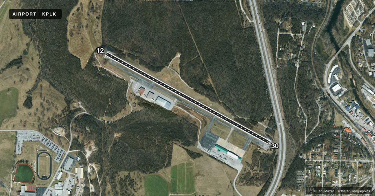
Runways & pattern
Full pagePattern entry · RWY 12
LEFT TRAFFICRunway end performance
| End | TORA | TODA | ASDA | LDA | VGSI | Approach lights | Obstruction |
|---|---|---|---|---|---|---|---|
| 30 | — | — | — | — | VASI 4-box right(3°) | — | — |
Declared distances in feet. TORA = takeoff run available, TODA = takeoff distance, ASDA = accelerate-stop, LDA = landing distance.
Airport sketch
Runways drawn to scale from FAA survey coordinates, rendered over satellite imagery. Not for navigation.
Approaches & charts
Services on the field
Fuel grades, oxygen, maintenance, ramp storage and lighting — as declared to the FAA by the airport operator.
Fuel & services
- Fuel
- 100LLA+
- Oxygen (bottled)
- Not available
- Airframe repair
- Minor
- Power plant repair
- Minor
- Other services
- AMB,INSTR,RNTL
Ramp & ground
- Transient storage
- Tie-down
- Hangar
- Landing fee
- No fee published
- Customs
- Not available
- Lighting schedule
- SEE RMK
- Beacon schedule
- SS-SR
- Beacon
- White / Green (civil land)(WG)
- Wind indicator
- Lighted
- Segmented circle
- Yes
Fuel & FBOs
Cheapest 100LL and Jet A on the field and nearby. Always confirm with the FBO before taxi.
Airport notes
Surface conditions, obstructions, local procedures, lighting outages and other notes published with each FAA cycle.
General notes
- NO SAFETY/OVERRUN AREAS AT RY ENDS-LARGE DROP-OFFS. STEEP TERRAIN GRADIENTS ALONG RY PVMT EDGES.
- GA SVCS AVBL EAST END OF AIRFIELD.
- STUDENT TRAINING ACTIVITIES IN THE AREA.
- DEER ON & INVOF ARPT.
- BRANSON ARPT ATTRACTIONS NEAR ARPTS.
- FOR CD CTC SPRINGFIELD APCH AT 417-868-5620/5619.
Lighting notes
- ACTVT REIL RWY 12 & 30; VASI RWY 30; MIRL RWY 12/30 - CTAF.
Approach & departure obstructions
- 12RWY 12 REIL LOCATED 105 FT FROM DTHR.
- 30RWY 30 REIL LOCATED 86 FT FROM DTHR.
- 1250:1 TO DSPLCD THLD.
- 3037:1 TO DSPLCD THLD.
Other notes
- MANAGER417-677-5300.
VFR map & nearby airports
VFR sectional. Tap any ICAO chip to open that airport.
Key facts · KPLK
Answer card- ICAO
- KPLK
- Name
- M GRAHAM CLARK DOWNTOWN
- Location
- BRANSON, MISSOURI
- Elevation
- 940.1 ft MSL
- Traffic pattern altitude
- 1,940.1 ft MSL (1,000 AGL)
- Control tower
- Non-towered (use CTAF)
- Total runways
- 1
- Longest runway
- 12/30 · 3,738 ft
- Published ILS approaches
- 0
- Published frequencies
- 3
- Magnetic variation
- 2°
- Current flight rules
- VFR
- Current wind
- 170° at 6 kt
- Favored runway now
- RWY 12
M Graham Clark Downtown Airport sits in Branson, Missouri. Field elevation is 940.1 ft MSL. The airport has one runway. Runway 12/30 is 3,738 ft long with asphalt pavement. There is no control tower. CTAF and UNICOM are both 122.7. Springfield Approach handles APCH and departure on 126.35. No ILS approaches are published here.
Pattern altitude is not published. Use the standard 1,000 ft AGL pattern unless local procedures or ATC say otherwise. That puts the light-aircraft pattern at about 1,940 ft MSL based on the field elevation. The on-field FBO is M. Graham Clark Downtown Airport. It carries 100LL and Jet A Prist. Call the FBO directly at (417) 332-1848 for current service details.
This field has some things a first-time pilot should plan for. The published remarks call out no safety or overrun areas at the runway ends. Large drop-offs and steep terrain gradients exist along the runway edges. Deer are also reported on and near the airport. Runway end identifier lights are active on both ends. Runway 30 also has a VASI. Student training activity is common in the area. For clearance delivery, Springfield Approach publishes phone numbers in the Chart Supplement. Check the current FAA Chart Supplement before you go for any updated procedures or local restrictions.