METAR & TAF KHRO
Current METAR
Observed 12:53Z
KHRO 271253Z AUTO 00000KT 10SM CLR 29/20 A3000 RMK AO2 SLP140 T02890200
- Wind
- 000° @ 0 kt
- Visibility
- 10 SM
- Temp / Dew
- 29°C / 20°C
- Altimeter
- 30.00 inHg
- Clouds
- CLR
- Density alt
- 3,273 ft
- Ceiling
- Unlimited
- Rules
- VFR
Airport info & contacts
Manager on record, flight service, ARTCC, attendance schedule and pattern altitude — published by the FAA and refreshed every 28 days.
Location
- From city
- 3 NM NW
- VFR sectional
- KANSAS CITY
- Pattern altitude
- 836 ft AGL · 2,201 ft MSL
- ARTCC
- ZME · MEMPHIS
- NOTAM facility
- HRO (NOTAM-D)
Airport manager
- Name
- JUDY MC CUTCHEON
- Phone
- 870-741-6954
- Address
- PO BOX 1114, HARRISON AR 72601
Flight service · Hours
- FSS JBR
- JONESBORO1-800-WX-BRIEF
- Attendance
- 0700-1900
Frequencies
Tap any row to copy the frequency to your clipboard.
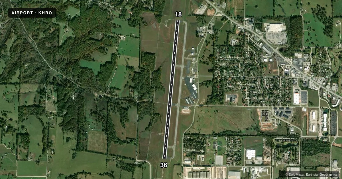
Runways & pattern
Full pagePattern entry · RWY 18
LEFT TRAFFICRunway end performance
| End | TORA | TODA | ASDA | LDA | VGSI | Approach lights | Obstruction |
|---|---|---|---|---|---|---|---|
| 18 | — | — | — | — | VASI 4-box left(3°) | — | — |
| 36 | — | — | — | — | VASI 4-box left(3°) | MALSR | — |
Declared distances in feet. TORA = takeoff run available, TODA = takeoff distance, ASDA = accelerate-stop, LDA = landing distance.
Airport sketch
Runways drawn to scale from FAA survey coordinates, rendered over satellite imagery. Not for navigation.
Approaches & charts
ILS · 1
Services on the field
Fuel grades, oxygen, maintenance, ramp storage and lighting — as declared to the FAA by the airport operator.
Fuel & services
- Fuel
- 100LLA
- Oxygen (bottled)
- Not available
- Oxygen (bulk)
- Not available
- Airframe repair
- Minor
- Power plant repair
- Minor
- Other services
- AFRT,AMB,CHTR,INSTR,RNTL
Ramp & ground
- Transient storage
- Tie-down
- Hangar
- Landing fee
- No fee published
- Customs
- Not available
- Lighting schedule
- SEE RMK
- Beacon schedule
- SS-SR
- Beacon
- White / Green (civil land)(WG)
- Wind indicator
- Lighted
- Segmented circle
- Yes
Fuel & FBOs
Cheapest 100LL and Jet A on the field and nearby. Always confirm with the FBO before taxi.
Airport notes
Surface conditions, obstructions, local procedures, lighting outages and other notes published with each FAA cycle.
General notes
- DEER & BIRDS ON & INVOF ARPT.
- FOR CD CTC MEMPHIS ARTCC AT 901-368-8453/8449.
Lighting notes
- ACTVT MALSR RWY 36, REIL RWY 18 & HIRL RWY 18/36 - CTAF.
Fuel notes
- 100LL100LL AVBL 24 HRS SELF SERVE.
Other notes
- THIS AIRPORT HAS BEEN SURVEYED BY THE NATIONAL GEODETIC SURVEY.
- 1FOR SVC AFT HRS CALL 870-741-4510; FEE CHRGD; CALL AHD IF POSS.
VFR map & nearby airports
VFR sectional. Tap any ICAO chip to open that airport.
Key facts · KHRO
Answer card- ICAO
- KHRO
- Name
- BOONE COUNTY
- Location
- HARRISON, ARKANSAS
- Elevation
- 1,364.5 ft MSL
- Traffic pattern altitude
- 2,200.5 ft MSL (836 AGL)
- Control tower
- Non-towered (use CTAF)
- Total runways
- 1
- Longest runway
- 18/36 · 6,161 ft
- Published ILS approaches
- 1
- Published frequencies
- 2
- Magnetic variation
- 4°
- Current flight rules
- VFR
- Current wind
- 000° at 0 kt
- Favored runway now
- –
Boone County Airport is in Harrison, Arkansas. The field elevation is 1,364.5 ft MSL. It has one runway. Runway 18/36 is 6,161 ft long with asphalt pavement. The airport is not towered. CTAF and UNICOM are both 123.0. Pattern altitude is 836 ft AGL, which is 2,200.5 ft MSL.
Runway 36 has an ILS. Published remarks also note MALSR lighting on runway 36. REIL is on runway 18. High intensity runway lighting is published for both ends. 100LL is available 24 hours by self-serve. Fly Arkansas is on the field. It carries AVGAS 100LL and Jet A Prist. For after-hours service, call the FBO at 870-741-4510. A fee is charged, so call ahead if you can. Deer and birds are reported on and near the airport, so keep a sharp scan on arrival and departure.
This is a non-towered field with a single runway, so standard CTAF discipline matters. If you need clearance delivery, contact Memphis ARTCC at the published phone numbers before departure. The airport sits in northwest Arkansas terrain, so plan your descent and pattern work with the field elevation in mind.