METAR & TAF 17A
17A does not publish a METAR.
Showing the nearest reporting station: KHRO (BOONE COUNTY) · 23.0 NM away. Conditions at 17A may differ.
METAR · KHRO
Observed 04:53Z
KHRO 270453Z AUTO 00000KT 10SM CLR 27/22 A2998 RMK AO2 SLP131 T02670222
- Wind
- 000° @ 0 kt
- Visibility
- 10 SM
- Temp / Dew
- 27°C / 22°C
- Altimeter
- 29.98 inHg
- Clouds
- CLR
- Density alt
- 3,412 ft
- Ceiling
- Unlimited
- Rules
- VFR
Airport info & contacts
Manager on record, flight service, ARTCC, attendance schedule and pattern altitude — published by the FAA and refreshed every 28 days.
Location
- From city
- 5 NM SW
- VFR sectional
- KANSAS CITY
- ARTCC
- ZME · MEMPHIS
- NOTAM facility
- JBR
Airport manager
- Name
- HARPER GOODWIN
- Phone
- 817-938-3334
- Address
- P.O. BOX 791, EUREKA SPRINGS AR 72632
Flight service · Hours
- FSS JBR
- JONESBORO1-800-WX-BRIEF
- Attendance
- UNATTND
Frequencies
Tap any row to copy the frequency to your clipboard.
Runways & pattern
Full pagePattern entry · RWY 10
RIGHT TRAFFICRunway end performance
| End | TORA | TODA | ASDA | LDA | VGSI | Approach lights | Obstruction |
|---|---|---|---|---|---|---|---|
| 10 | — | — | — | — | — | — | 23', tree, 250' from thr, 55' R of cntrln, slope 10 |
| 28 | — | — | — | — | — | — | 50', trees, 150' from thr, 0' R of cntrln, slope 3 |
Declared distances in feet. TORA = takeoff run available, TODA = takeoff distance, ASDA = accelerate-stop, LDA = landing distance.
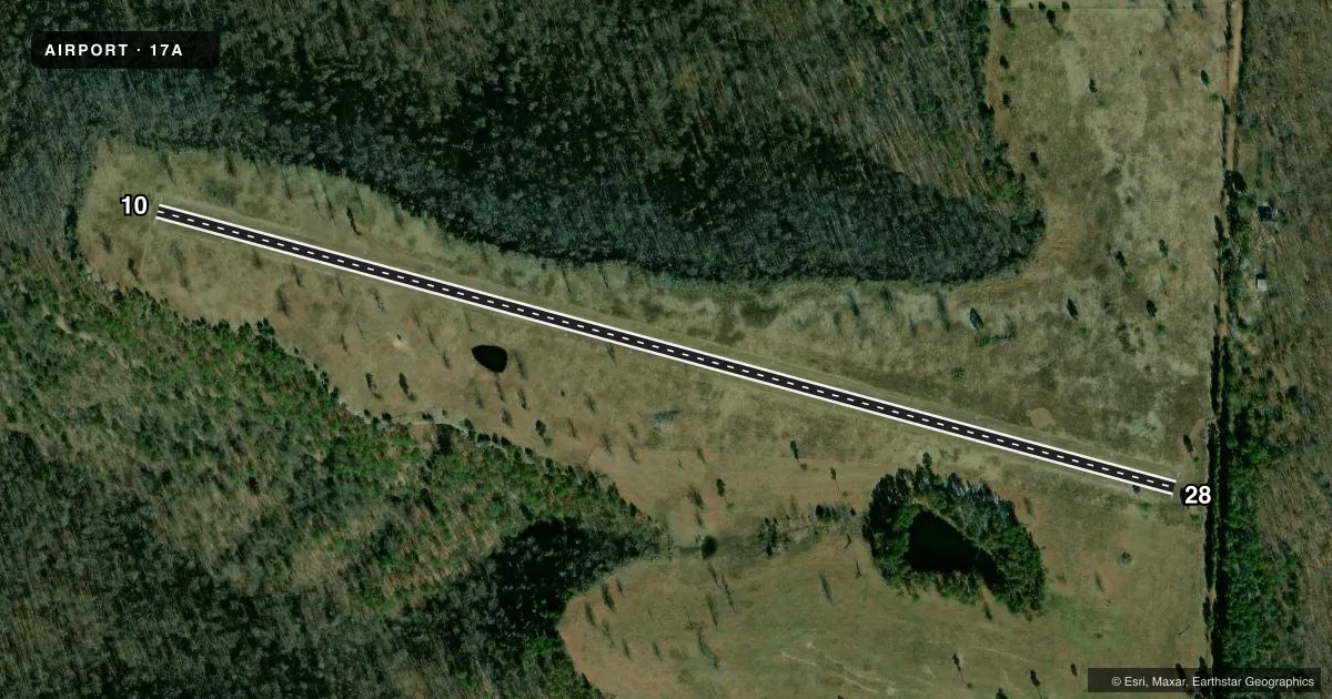
Airport sketch
Runways drawn to scale from FAA survey coordinates, rendered over satellite imagery. Not for navigation.
Approaches & charts
Services on the field
Fuel grades, oxygen, maintenance, ramp storage and lighting — as declared to the FAA by the airport operator.
Fuel & services
- Fuel
- Not available
Ramp & ground
- Transient storage
- Not published
Fuel & FBOs
Cheapest 100LL and Jet A on the field and nearby. Always confirm with the FBO before taxi.
Airport notes
Surface conditions, obstructions, local procedures, lighting outages and other notes published with each FAA cycle.
General notes
- FOR CD CTC RAZORBACK APCH 479-649-2416, WHEN APCH CLSD CTC MEMPHIS ARTCC AT 901-368-8453/8449.
- DEER ON & INVOF ARPT
VFR map & nearby airports
VFR sectional. Tap any ICAO chip to open that airport.
Key facts · 17A
Answer card- ICAO
- 17A
- Name
- TRIGGER GAP
- Location
- BERRYVILLE, ARKANSAS
- Elevation
- 1,650 ft MSL
- Traffic pattern altitude
- 2,650 ft MSL (1,000 AGL)
- Control tower
- Non-towered (use CTAF)
- Total runways
- 1
- Longest runway
- 10/28 · 3,000 ft
- Published ILS approaches
- 0
- Published frequencies
- 1
- Magnetic variation
- –
- Current flight rules
- VFR
- Current wind
- 000° at 0 kt
- Favored runway now
- –
Trigger Gap Airport (17A) is in Berryville, Arkansas. The field elevation is 1,650 ft MSL. It has one runway, 10/28, which is 3,000 ft of turf. The longest runway is 3,000 ft. The airport is non-towered. CTAF is 122.9.
No ILS approaches are published here. Pattern altitude is not published in the facts. Use the standard 1,000 ft AGL pattern unless the current Chart Supplement says otherwise. Deer are reported on and near the airport. Keep a sharp scan on taxi, takeoff and landing. For clearance delivery, contact Razorback Approach at 479-649-2416. When approach is closed, contact Memphis ARTCC at 901-368-8453 or 901-368-8449.
There are no on-field FBOs listed in the facts. Plan accordingly and verify current services with the airport operator or the field by phone before arrival. With a turf runway and a 1,650 ft elevation, performance planning matters. Check density altitude, runway condition and wind before you go. If you are arriving VFR, review the current sectional and the current FAA Chart Supplement for any updates before flight.