METAR & TAF KFWB
Current METAR
Observed 18:35Z
KFWB 271835Z AUTO 20007G15KT 150V230 6SM UP HZ CLR 36/18 A2992 RMK AO2
- Wind
- 200° @ 7G15 kt
- Visibility
- 6 SM
- Temp / Dew
- 36°C / 18°C
- Altimeter
- 29.92 inHg
- Clouds
- CLR
- Density alt
- 4,192 ft
- Ceiling
- Unlimited
- Rules
- VFR
Airport info & contacts
Manager on record, flight service, ARTCC, attendance schedule and pattern altitude — published by the FAA and refreshed every 28 days.
Location
- From city
- 2 NM W
- VFR sectional
- KANSAS CITY
- ARTCC
- ZKC · KANSAS CITY
- NOTAM facility
- FWB (NOTAM-D)
Airport manager
- Name
- CITY OF BRANSON WEST
- Phone
- 417-272-3921
- Address
- 393 AERO DRIVE, BRANSON WEST MO 65737
Flight service · Hours
- FSS COU
- COLUMBIA1-800-WX-BRIEF
- Attendance
- 0800-1700
Frequencies
Tap any row to copy the frequency to your clipboard.
Runways & pattern
Full pagePattern entry · RWY 21
RIGHT TRAFFICRunway end performance
| End | TORA | TODA | ASDA | LDA | VGSI | Approach lights | Obstruction |
|---|---|---|---|---|---|---|---|
| 03 | — | — | — | — | PAPI 4-box right(3°) | — | — |
| 21 | — | — | — | — | PAPI 4-box left(3°) | — | — |
Declared distances in feet. TORA = takeoff run available, TODA = takeoff distance, ASDA = accelerate-stop, LDA = landing distance.
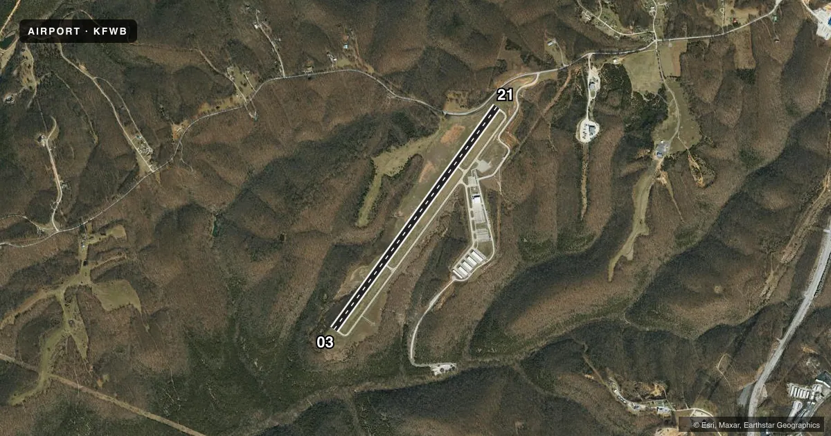
Airport sketch
Runways drawn to scale from FAA survey coordinates, rendered over satellite imagery. Not for navigation.
Approaches & charts
Services on the field
Fuel grades, oxygen, maintenance, ramp storage and lighting — as declared to the FAA by the airport operator.
Fuel & services
- Fuel
- 100LLA
- Oxygen (bottled)
- Low pressure
- Oxygen (bulk)
- Not available
- Airframe repair
- Minor
- Power plant repair
- Minor
- Other services
- INSTR,RNTL
Ramp & ground
- Transient storage
- Tie-down
- Hangar
- Landing fee
- No fee published
- Lighting schedule
- SEE RMK
- Beacon schedule
- SS-SR
- Beacon
- White / Green (civil land)(WG)
- Wind indicator
- Lighted
- Segmented circle
- No
Fuel & FBOs
Cheapest 100LL and Jet A on the field and nearby. Always confirm with the FBO before taxi.
Airport notes
Surface conditions, obstructions, local procedures, lighting outages and other notes published with each FAA cycle.
General notes
- FOR CD CTC SPRINGFIELD APCH AT 417-868-5620/5619.
Lighting notes
- ACTVT MIRL RWY 03/21 AND REIL RWY 03 & RWY 21 - CTAF; PAPIS RWY 03 AND RWY 21-OPER CONTINUOUSLY.
Fuel notes
- 100LLSELF SVC 100LL AVBL WITH CREDIT CARD 24 HRS.
Other notes
- 1AFTER HOURS CALL: 417-893-0269.
VFR map & nearby airports
VFR sectional. Tap any ICAO chip to open that airport.
Key facts · KFWB
Answer card- ICAO
- KFWB
- Name
- BRANSON WEST MUNI/EMERSON FLD
- Location
- BRANSON WEST, MISSOURI
- Elevation
- 1,348.1 ft MSL
- Traffic pattern altitude
- 2,348.1 ft MSL (1,000 AGL)
- Control tower
- Non-towered (use CTAF)
- Total runways
- 1
- Longest runway
- 03/21 · 5,002 ft
- Published ILS approaches
- 0
- Published frequencies
- 3
- Magnetic variation
- 2°
- Current flight rules
- VFR
- Current wind
- 200° at 7 kt
- Favored runway now
- RWY 21
Branson West Muni/Emerson Fld sits in Branson West, Missouri. Field elevation is 1,348.1 ft MSL. The airport has one runway, 03/21, which is 5,002 ft long. There is no control tower. The field uses CTAF 123.0 and UNICOM 123.0. Springfield Approach handles APCH/P DEP/P on 126.35.
No ILS approaches are published here. Pattern altitude is not published, so use the standard 1,000 ft AGL for light piston traffic unless the current Chart Supplement says otherwise. The runway has medium intensity lights on 03/21. REILs are installed on both runway ends. PAPI operates continuously on runway 03 and runway 21.
Branson West Municipal Airport is the on-field FBO. It carries 100LL, Jet A and Jet A Prist. Self-serve 100LL is available with credit card 24 hours. After hours, call the number in the remarks before you plan a late arrival.
This is a high-elevation field for the region. Expect a little more performance planning than at a lowland airport. The published remarks also point you to Springfield Approach for clearance delivery. If you are arriving IFR or need current local procedures, check the current FAA Chart Supplement or call the airport operator before departure.