METAR & TAF 2H2
2H2 does not publish a METAR.
Showing the nearest reporting station: KHFJ (MONETT RGNL) · 15.7 NM away. Conditions at 2H2 may differ.
METAR · KHFJ
Observed 20:35Z
KHFJ 272035Z AUTO 25010KT 10SM CLR 36/19 A2988 RMK AO2
- Wind
- 250° @ 10 kt
- Visibility
- 10 SM
- Temp / Dew
- 36°C / 19°C
- Altimeter
- 29.88 inHg
- Clouds
- CLR
- Density alt
- 4,347 ft
- Ceiling
- Unlimited
- Rules
- VFR
Airport info & contacts
Manager on record, flight service, ARTCC, attendance schedule and pattern altitude — published by the FAA and refreshed every 28 days.
Location
- From city
- 2 NM SE
- VFR sectional
- KANSAS CITY
- ARTCC
- ZKC · KANSAS CITY
- NOTAM facility
- COU (NOTAM-D)
Airport manager
- Name
- JUSTIN RICHMOND
- Phone
- 417-236-4118
- Address
- 1526 E. HIGHLAND, AURORA MO 65605
Flight service · Hours
- FSS COU
- COLUMBIA1-800-WX-BRIEF
- Attendance
- Unattended
Frequencies
Tap any row to copy the frequency to your clipboard.
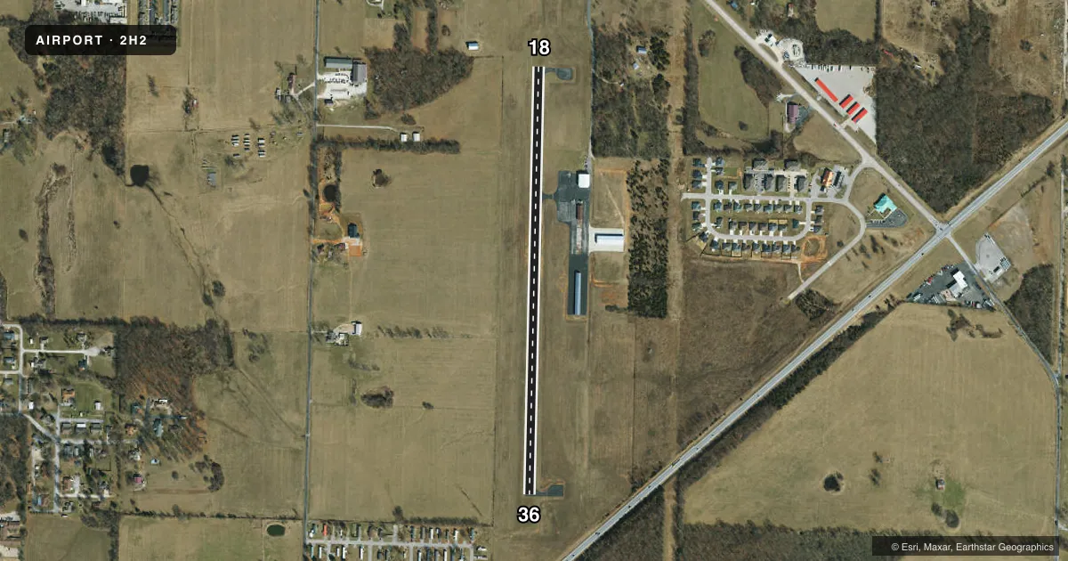
Runways & pattern
Full pagePattern entry · RWY 18
LEFT TRAFFICRunway end performance
| End | TORA | TODA | ASDA | LDA | VGSI | Approach lights | Obstruction |
|---|---|---|---|---|---|---|---|
| 36 | — | — | — | — | — | — | 18', road, 420' from thr, 290' R of cntrln, slope 12 |
Declared distances in feet. TORA = takeoff run available, TODA = takeoff distance, ASDA = accelerate-stop, LDA = landing distance.
Airport sketch
Runways drawn to scale from FAA survey coordinates, rendered over satellite imagery. Not for navigation.
Approaches & charts
Services on the field
Fuel grades, oxygen, maintenance, ramp storage and lighting — as declared to the FAA by the airport operator.
Fuel & services
- Fuel
- 100LL
- Oxygen (bottled)
- Not available
- Oxygen (bulk)
- Not available
- Airframe repair
- Not available
- Power plant repair
- Not available
- Other services
- INSTR,RNTL
Ramp & ground
- Transient storage
- Tie-down
- Hangar
- Landing fee
- No fee published
- Customs
- Not available
- Lighting schedule
- SEE RMK
- Beacon schedule
- SS-SR
- Beacon
- White / Green (civil land)(WG)
- Wind indicator
- Lighted
- Segmented circle
- Yes
Fuel & FBOs
Cheapest 100LL and Jet A on the field and nearby. Always confirm with the FBO before taxi.
Airport notes
Surface conditions, obstructions, local procedures, lighting outages and other notes published with each FAA cycle.
General notes
- STAFF ON DUTY; MON THRU SAT; 8AM - 5PM. CALL 877-235-9327 EXT 1.
- FOR CD CTC SPRINGFIELD APCH AT 417-868-5620/5619.
Lighting notes
- ACTVT MIRL RWY 18/36 - CTAF.
VFR map & nearby airports
VFR sectional. Tap any ICAO chip to open that airport.
Key facts · 2H2
Answer card- ICAO
- 2H2
- Name
- JERRY SUMNERS SR AURORA MUNI
- Location
- AURORA, MISSOURI
- Elevation
- 1,433.6 ft MSL
- Traffic pattern altitude
- 2,433.6 ft MSL (1,000 AGL)
- Control tower
- Non-towered (use CTAF)
- Total runways
- 1
- Longest runway
- 18/36 · 3,001 ft
- Published ILS approaches
- 0
- Published frequencies
- 4
- Magnetic variation
- 3°
- Current flight rules
- VFR
- Current wind
- 250° at 10 kt
- Favored runway now
- RWY 18
Jerry Sumners Sr Aurora Muni (2H2) sits in Aurora, Missouri. The field elevation is 1,433.6 ft MSL. It has one runway. Runway 18/36 is 3,001 ft long with asphalt surface. There is no control tower. Springfield Approach handles the published approach and departure frequencies. No ILS approaches are published here.
The pattern altitude is not published. Use the standard 1,000 ft AGL pattern for light piston traffic unless the current Chart Supplement says otherwise. The published runway lights on 18/36 are medium intensity. They are activated by using the CTAF. EAS Flight Training is on the field. It carries AVGAS 100LL.
For clearance delivery, the published remarks direct pilots to Springfield Approach by phone. Staff are listed as on duty Monday through Saturday from 8 AM to 5 PM. This is a non-towered field with a single short asphalt runway at moderate elevation. That means runway length matters. Density altitude matters too. Local traffic discipline matters as well. Check the current Chart Supplement before you go for any updates to lighting, procedures, or operational remarks.