METAR & TAF MO9
MO9 does not publish a METAR.
Showing the nearest reporting station: KHFJ (MONETT RGNL) · 19.9 NM away. Conditions at MO9 may differ.
METAR · KHFJ
Observed 19:15Z
KHFJ 271915Z AUTO 20013G16KT 10SM SCT060 35/19 A2991 RMK AO2
- Wind
- 200° @ 13G16 kt
- Visibility
- 10 SM
- Temp / Dew
- 35°C / 19°C
- Altimeter
- 29.91 inHg
- Clouds
- SCT
- Density alt
- 3,990 ft
- Ceiling
- Unlimited
- Rules
- VFR
Airport info & contacts
Manager on record, flight service, ARTCC, attendance schedule and pattern altitude — published by the FAA and refreshed every 28 days.
Location
- From city
- 5 NM W
- VFR sectional
- KANSAS CITY
- ARTCC
- ZKC · KANSAS CITY
- NOTAM facility
- COU (NOTAM-D)
Airport manager
- Name
- KIMAN KINGSLEY
- Phone
- 417-452-3831
- Address
- 3388 LAWRENCE 1070, MILLER MO 65707
Flight service · Hours
- FSS COU
- COLUMBIA1-800-WX-BRIEF
- Attendance
- DAWN-DUSK
Frequencies
Tap any row to copy the frequency to your clipboard.
Runways & pattern
Full pagePattern entry · RWY 18
RIGHT TRAFFICRunway end performance
| End | TORA | TODA | ASDA | LDA | VGSI | Approach lights | Obstruction |
|---|---|---|---|---|---|---|---|
| 18 | — | — | — | — | — | — | 15', road, 32' from thr, 125' R of cntrln, slope 2 |
Declared distances in feet. TORA = takeoff run available, TODA = takeoff distance, ASDA = accelerate-stop, LDA = landing distance.
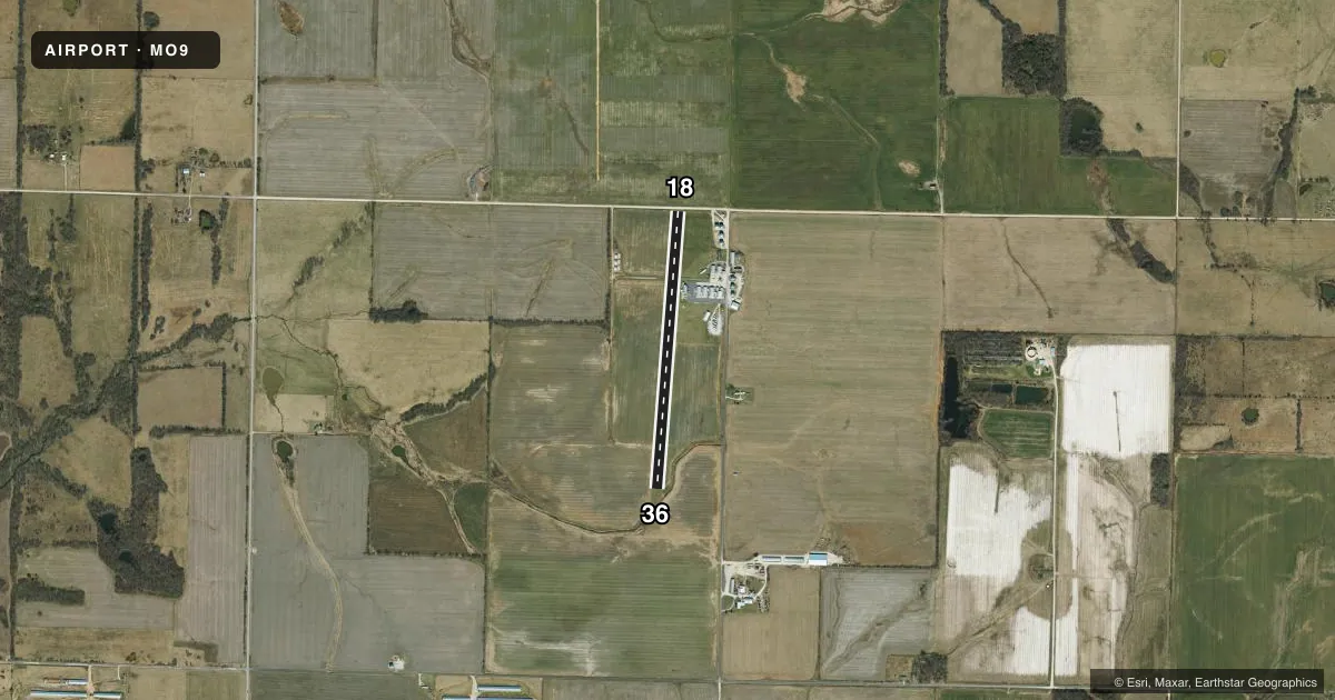
Airport sketch
Runways drawn to scale from FAA survey coordinates, rendered over satellite imagery. Not for navigation.
Approaches & charts
Services on the field
Fuel grades, oxygen, maintenance, ramp storage and lighting — as declared to the FAA by the airport operator.
Fuel & services
- Fuel
- 100LLA+
- Airframe repair
- Major
- Power plant repair
- Major
- Other services
- AGRI,INSTR,PAJA
Ramp & ground
- Transient storage
- Tie-down
- Hangar
- Lighting schedule
- SS-SR
- Beacon schedule
- SS-SR
- Beacon
- White / Green (civil land)(WG)
- Wind indicator
- Yes
- Segmented circle
- No
Fuel & FBOs
Cheapest 100LL and Jet A on the field and nearby. Always confirm with the FBO before taxi.
Airport notes
Surface conditions, obstructions, local procedures, lighting outages and other notes published with each FAA cycle.
General notes
- HEAVY AGRICULTURAL OPNS.
- AG TRAINING AVAILABLE
- 375 FT AGL ANT TWR APRXLY 2.2 SM S OF ARPT.
- FOR CD CTC SPRINGFIELD APCH AT 417-868-5620/5619.
- AFTER HOURS PHONE CALL TO 417-844-1535
Runway surface & condition
- 18/36RWY 18/36 1865 FT X 18 FT CHIP SEALSUPERIMPOSED, 225 FT S OF RWY 18 THLD; REMAINDER TURF.
- 18/36NSTD LIRL: RWY 18/36 NSTD LIRL DUE TO NSTD FIXTURES. RWY 18/36 SOUTH 480 FT NOT LIGHTED.
VFR map & nearby airports
VFR sectional. Tap any ICAO chip to open that airport.
Key facts · MO9
Answer card- ICAO
- MO9
- Name
- KINGSLEY AIRFIELD
- Location
- MILLER, MISSOURI
- Elevation
- 1,272 ft MSL
- Traffic pattern altitude
- 2,272 ft MSL (1,000 AGL)
- Control tower
- Non-towered (use CTAF)
- Total runways
- 1
- Longest runway
- 18/36 · 3,119 ft
- Published ILS approaches
- 0
- Published frequencies
- 1
- Magnetic variation
- –
- Current flight rules
- VFR
- Current wind
- 200° at 13 kt
- Favored runway now
- RWY 18
Kingsley Airfield sits near Miller, Missouri at 1,272 ft MSL. It has one runway, 18/36, which is 3,119 ft long. The field is non-towered. CTAF is 122.9. No ILS approaches are published here.
The pattern altitude is not published. Use the standard 1,000 ft AGL pattern unless the current Chart Supplement says otherwise. That puts the light piston pattern at about 2,272 ft MSL based on the field elevation, but verify before you fly. The runway surface is listed as asphalt-turf. Published remarks also say the south 480 ft of runway 18/36 is not lighted. The runway has nonstandard low intensity lighting due to nonstandard fixtures.
This is an ag field. Heavy agricultural operations occur. Agricultural training is available. There is also a 375 ft AGL antenna tower about 2.2 SM south of the airport, so keep that in mind on arrival and departure. After hours phone contact is 417-844-1535. For clearance delivery, contact Springfield Approach at 417-868-5620 or 417-868-5619. No on-field FBOs are listed, so call the airport operator or the field directly before arrival if you need current services.