METAR & TAF 2MO
2MO does not publish a METAR.
Showing the nearest reporting station: KHFJ (MONETT RGNL) · 11.6 NM away. Conditions at 2MO may differ.
METAR · KHFJ
Observed 11:35Z
KHFJ 271135Z AUTO 18003KT 10SM CLR 24/20 A2996 RMK AO2
- Wind
- 180° @ 3 kt
- Visibility
- 10 SM
- Temp / Dew
- 24°C / 20°C
- Altimeter
- 29.96 inHg
- Clouds
- CLR
- Density alt
- 2,573 ft
- Ceiling
- Unlimited
- Rules
- VFR
Airport info & contacts
Manager on record, flight service, ARTCC, attendance schedule and pattern altitude — published by the FAA and refreshed every 28 days.
Location
- From city
- 3 NM SW
- VFR sectional
- KANSAS CITY
- ARTCC
- ZKC · KANSAS CITY
- NOTAM facility
- COU (NOTAM-D)
Airport manager
- Name
- JOE KELLEY
- Phone
- 417-466-2122
- Address
- 319 E. DALLAS, P.O. BOX 70, MOUNT VERNON MO 65712
Flight service · Hours
- FSS COU
- COLUMBIA1-800-WX-BRIEF
- Attendance
- IREG
Frequencies
Tap any row to copy the frequency to your clipboard.
Runways & pattern
Full pagePattern entry · RWY 18
LEFT TRAFFICRunway end performance
| End | TORA | TODA | ASDA | LDA | VGSI | Approach lights | Obstruction |
|---|---|---|---|---|---|---|---|
| 36 | — | — | — | — | — | — | 5', fence, 200' from thr, 125' R of cntrln, slope 0 |
Declared distances in feet. TORA = takeoff run available, TODA = takeoff distance, ASDA = accelerate-stop, LDA = landing distance.
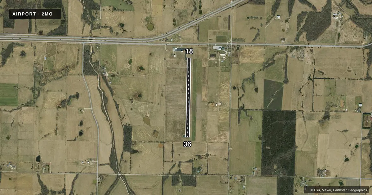
Airport sketch
Runways drawn to scale from FAA survey coordinates, rendered over satellite imagery. Not for navigation.
Approaches & charts
Services on the field
Fuel grades, oxygen, maintenance, ramp storage and lighting — as declared to the FAA by the airport operator.
Fuel & services
- Fuel
- Not available
- Oxygen (bottled)
- Not available
- Oxygen (bulk)
- Not available
- Airframe repair
- Not available
- Power plant repair
- Not available
- Other services
- PAJA
Ramp & ground
- Transient storage
- Tie-down
- Landing fee
- No fee published
- Customs
- Not available
- Lighting schedule
- SEE RMK
- Wind indicator
- Lighted
- Segmented circle
- No
Fuel & FBOs
Cheapest 100LL and Jet A on the field and nearby. Always confirm with the FBO before taxi.
Airport notes
Surface conditions, obstructions, local procedures, lighting outages and other notes published with each FAA cycle.
General notes
- PAJA ON & INVOF ARPT.
- INSUF RWY SAFETY AREA LENGTH BYND RWY 36 END.
- FOR CD CTC SPRINGFIELD APCH AT 417-868-5620/5619.
Lighting notes
- ACTVT MIRL RY 18/36 - CTAF.
Approach & departure obstructions
- 36RY 36 1-25 FT BRUSH AND SMALL TREES 195-200 FT FROM RY END L & R.
Other notes
- MANAGERCITY PUBLIC WORKS DIRECTOR.
- OWNERSUBLEASED TO THE CITY OF MOUNT VERNON.
VFR map & nearby airports
VFR sectional. Tap any ICAO chip to open that airport.
Key facts · 2MO
Answer card- ICAO
- 2MO
- Name
- MOUNT VERNON MUNI
- Location
- MOUNT VERNON, MISSOURI
- Elevation
- 1,244 ft MSL
- Traffic pattern altitude
- 2,244 ft MSL (1,000 AGL)
- Control tower
- Non-towered (use CTAF)
- Total runways
- 1
- Longest runway
- 18/36 · 3,195 ft
- Published ILS approaches
- 0
- Published frequencies
- 1
- Magnetic variation
- 5°
- Current flight rules
- VFR
- Current wind
- 180° at 3 kt
- Favored runway now
- RWY 18
Mount Vernon Muni sits in Mount Vernon, Missouri. The field elevation is 1,244 ft MSL. It has one asphalt runway, 18/36, at 3,195 ft. There is no control tower. CTAF is 122.9. No ILS approaches are published here.
Pattern altitude is not published. Use the standard 1,000 ft AGL pattern unless local procedures or current chart data say otherwise. The runway lights are medium intensity lights on runway 18/36. They are activated by CTAF. That helps for night ops, but you still need to brief the field before arrival.
The published remarks matter here. Runway 36 has brush and small trees near the departure end, left and right. The runway safety area beyond runway 36 is also limited. That makes a stabilized approach and a careful takeoff brief important. The airport is subleased to the city of Mount Vernon. The manager is the city public works director. For clearance delivery, Springfield Approach is listed in the remarks. Paja is noted on and near the airport. No on-field FBOs are listed, so contact the airport operator directly before arrival or call the field on CTAF for current services.