METAR & TAF KSGF
Current METAR
Observed 19:52Z
KSGF 271952Z 25012G20KT 10SM CLR 36/20 A2987 RMK AO2 SLP098 T03560200
- Wind
- 250° @ 12G20 kt
- Visibility
- 10 SM
- Temp / Dew
- 36°C / 20°C
- Altimeter
- 29.87 inHg
- Clouds
- CLR
- Density alt
- 4,155 ft
- Ceiling
- Unlimited
- Rules
- VFR
Airport info & contacts
Manager on record, flight service, ARTCC, attendance schedule and pattern altitude — published by the FAA and refreshed every 28 days.
Location
- From city
- 5 NM NW
- VFR sectional
- KANSAS CITY
- Pattern altitude
- 1,000 ft AGL · 2,268 ft MSL
- ARTCC
- ZKC · KANSAS CITY
- NOTAM facility
- SGF (NOTAM-D)
Airport manager
- Name
- MR. BRIAN C WEILER, A.A.E.
- Phone
- 417-868-0500
- Address
- 2300 N AIRPORT BLVD, SUITE 100, SPRINGFIELD MO 65802
Flight service · Hours
- FSS COU
- COLUMBIA1-800-WX-BRIEF
- Attendance
- ALL
Frequencies
Tap any row to copy the frequency to your clipboard.
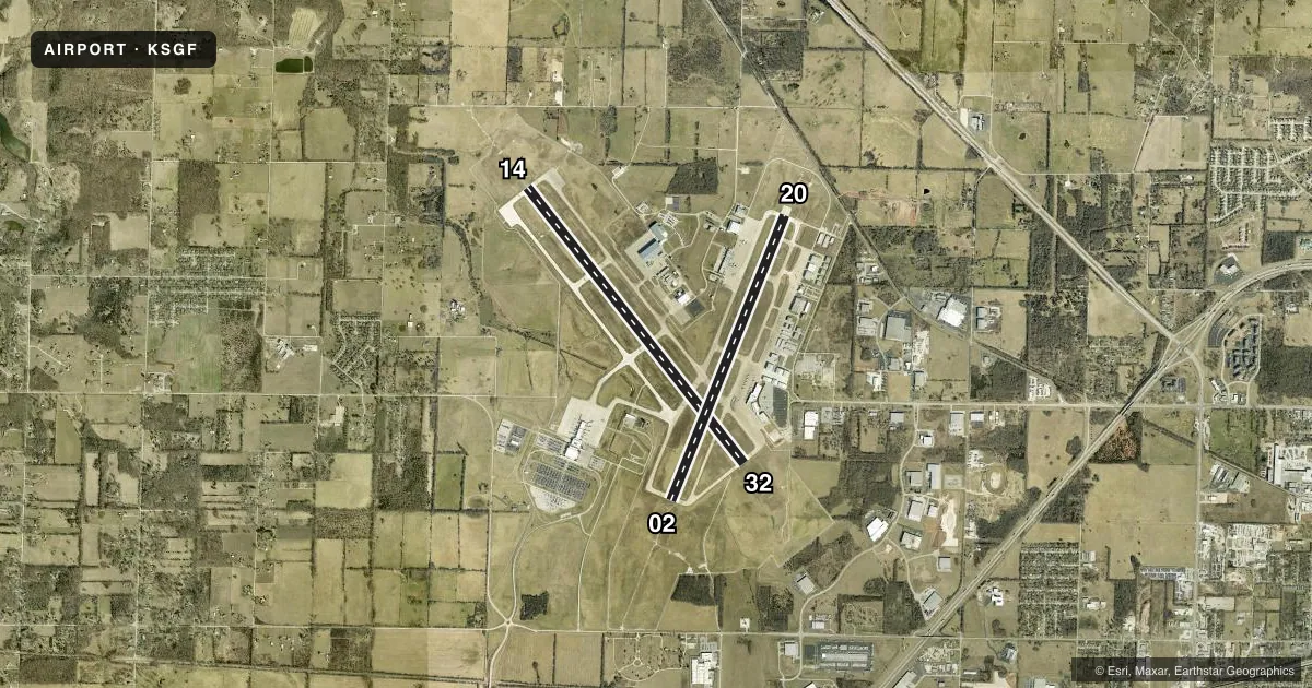
Runways & pattern
Full pagePattern entry · RWY 20
LEFT TRAFFIC| Runway | Heading (°M) | Length | Surface | Traffic |
|---|---|---|---|---|
| 14/32 | 139° / 319° | 8,000 ft | CONC | Standard L |
| 02/20Favored | 19° / 199° | 7,003 ft | CONC | Standard L |
Runway end performance
| End | TORA | TODA | ASDA | LDA | VGSI | Approach lights | Obstruction |
|---|---|---|---|---|---|---|---|
| 14 | 8,000' | 8,000' | 8,000' | 8,000' | PAPI 4-box right(3°) | MALSR | — |
| 32 | 8,000' | 8,000' | 8,000' | 8,000' | PAPI 4-box left(3°) | — | — |
| 02 | 7,003' | 7,003' | 7,003' | 7,003' | VASI 4-box left(3°) | MALSR | — |
| 20 | 7,003' | 7,003' | 7,003' | 7,003' | PAPI 4-box left(3°) | MALS | — |
Declared distances in feet. TORA = takeoff run available, TODA = takeoff distance, ASDA = accelerate-stop, LDA = landing distance.
Airport sketch
Runways drawn to scale from FAA survey coordinates, rendered over satellite imagery. Not for navigation.
Approaches & charts
ILS · 2
Services on the field
Fuel grades, oxygen, maintenance, ramp storage and lighting — as declared to the FAA by the airport operator.
Fuel & services
- Fuel
- 100LLA
- Oxygen (bottled)
- Not available
- Oxygen (bulk)
- HIGH/LOW
- Airframe repair
- Major
- Power plant repair
- Major
- Other services
- AFRT,AMB,AVNCS,CHTR,INSTR,RNTL,SALES
Ramp & ground
- Transient storage
- Tie-down
- Hangar
- Landing fee
- No fee published
- Customs
- Not available
- Lighting schedule
- SS-SR
- Beacon schedule
- SS-SR
- Beacon
- White / Green (civil land)(WG)
- Wind indicator
- Lighted
- Segmented circle
- No
Fuel & FBOs
Cheapest 100LL and Jet A on the field and nearby. Always confirm with the FBO before taxi.
Airport notes
Surface conditions, obstructions, local procedures, lighting outages and other notes published with each FAA cycle.
General notes
- BIRDS & WILDLIFE ON & INVOF ARPT.
- TWY N SOUTH OF RY 14-32 CLSD TO A-321, B727-200, ALL MD 80 SERIES, B-757 AND LARGER ACFT.
- COMPASS ROSE NORTH OF TWY D AT THE APCH END RWY 32 RESTRICTED TO ACFT WITH FLUX VALVE & STBY COMPASS OF 5.5 FT IN HGT OR HYR.
- GROUP IV ACFT OR LRGR ON TWY D FROM THE AER 32 TO TWY N AND TWY U ALG CARGO APN MUST PERFORM JUDGMENTAL OVERSTEERING INSTEAD OF COCKPIT OVER CNTRLN WHEN TAX.
- ARNG - MO-AVCRAD FAC OPR 1300-2100Z++ MON-FRI EXC HOL. MAINT ASST AVBL DUR NML DUTY HR. FLT ACT OPR 1400-2130Z++ MON-FRI EXC HOL. EXTN HR ON TUES, WED, THU 1400-0200Z++. DUR DST EXTN HR ONLY ON WED, THUR 1400-0500Z++. ARNG-24 HR PPR REQ, VALID 1 HR +/- ETA. FOR PPR, CTC FLT OPS AT C417-874-8460 DUR NML DUTY HR. ALL ACFT RQR CTC BEARS DEN ON 38.525, 138.75 AND 245.6 DEP ACFT RQR TO CTC BEARS DEN TO ADHERE TO ARPT SECURITY MEASURES. TRAN ACFT SHALL ARR AND DEP FR TWY G OR TWY J. A++ FUEL AVBL FOR SUPPORTED AVCRAD ACFT. RWY - ALL RWY GROOVED. RWY 02 RVR-T. TWY 20 RVR-R. RWY 14 RVR-T. RWY 32 RVR-R.
Runway surface & condition
- 02/20PCR VALUE: 780/R/D/W/T
- 14/32PCR VALUE: 780/R/D/W/T
Other notes
- OXYGEN AVBL MON-FRI 0800-1700.
- PPR 24 HRS FOR UNSKED ACR OPNS WITH MORE THAN 30 PSGR SEATS CALL SGF 417-868-0590. ARFF INDEX C & D AVBL ON REQUEST.
- MANAGERDIRECTOR OF AVIATION.
VFR map & nearby airports
VFR sectional. Tap any ICAO chip to open that airport.
Key facts · KSGF
Answer card- ICAO
- KSGF
- Name
- SPRINGFIELD-BRANSON NTL
- Location
- SPRINGFIELD, MISSOURI
- Elevation
- 1,268.3 ft MSL
- Traffic pattern altitude
- 2,268.3 ft MSL (1,000 AGL)
- Control tower
- Towered · 24
- Total runways
- 2
- Longest runway
- 14/32 · 8,000 ft
- Published ILS approaches
- 2
- Published frequencies
- 15
- Magnetic variation
- 3°
- Current flight rules
- VFR
- Current wind
- 250° at 12 kt
- Favored runway now
- RWY 20
KSGF is in Springfield, Missouri. Field elevation is 1,268.3 ft MSL. The airport has 2 runways. The longest is 8,000 ft on runway 14/32. The tower is open 24 hours. The field sits in Class C airspace. There are 2 ILS approaches. They serve runway ends 02 and 14.
Pattern altitude is 1,000 ft AGL. That is 2,268.3 ft MSL. Runway 02/20 is 7,003 ft concrete. Runway 14/32 is 8,000 ft concrete. Midwest Premier SGF Aviation is on the field. It carries 100LL and Jet A Prist. Call (417) 868-0590 for current service details.
A few published remarks matter here. Taxiway N south of runway 14/32 is closed to Airbus A321, Boeing 727-200, all MD-80 series, Boeing 757 and larger aircraft. Birds and wildlife are reported on and near the airport. Some special operations require prior permission. If you are planning anything outside normal transient use, call the airport operator or the FBO directly before arrival. The airport also notes grooved runways and security procedures for departing aircraft. For a first-time arrival, brief the Class C work. Watch the runway and taxiway geometry. Verify any special-use restrictions before you launch.