METAR & TAF M17
M17 does not publish a METAR.
Showing the nearest reporting station: KSGF (SPRINGFIELD-BRANSON NTL) · 21.2 NM away. Conditions at M17 may differ.
METAR · KSGF
Observed 20:52Z
KSGF 272052Z 25011KT 10SM CLR 36/20 A2986 RMK AO2 SLP094 T03610200 56021
- Wind
- 250° @ 11 kt
- Visibility
- 10 SM
- Temp / Dew
- 36°C / 20°C
- Altimeter
- 29.86 inHg
- Clouds
- CLR
- Density alt
- 3,950 ft
- Ceiling
- Unlimited
- Rules
- VFR
Airport info & contacts
Manager on record, flight service, ARTCC, attendance schedule and pattern altitude — published by the FAA and refreshed every 28 days.
Location
- From city
- 4 NM E
- VFR sectional
- KANSAS CITY
- ARTCC
- ZKC · KANSAS CITY
- NOTAM facility
- COU (NOTAM-D)
Airport manager
- Name
- KERRICK TWEEDY
- Phone
- 417-777-6800
- Address
- 4460 ARPT DR, BOLIVAR MO 65613
Flight service · Hours
- FSS COU
- COLUMBIA1-800-WX-BRIEF
- Attendance
- MON-SAT · 0800-1700
Frequencies
Tap any row to copy the frequency to your clipboard.
Runways & pattern
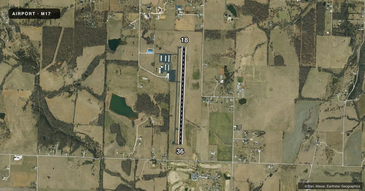
Full pagePattern entry · RWY 18
LEFT TRAFFIC| Runway | Heading (°M) | Length | Surface | Traffic |
|---|---|---|---|---|
| 18/36Favored | 180° / 0° | 4,000 ft | ASPH | Standard L |
| 17/35 | 179° / 359° | 2,120 ft | TURF | Standard L |
Runway end performance
| End | TORA | TODA | ASDA | LDA | VGSI | Approach lights | Obstruction |
|---|---|---|---|---|---|---|---|
| 18 | — | — | — | — | PAPI 2-box left(3.75°) | — | — |
| 36 | — | — | — | — | PAPI 2-box left(3°) | — | — |
Declared distances in feet. TORA = takeoff run available, TODA = takeoff distance, ASDA = accelerate-stop, LDA = landing distance.
Airport sketch
Runways drawn to scale from FAA survey coordinates, rendered over satellite imagery. Not for navigation.
Approaches & charts
Services on the field
Fuel grades, oxygen, maintenance, ramp storage and lighting — as declared to the FAA by the airport operator.
Fuel & services
- Fuel
- 100LLA
- Airframe repair
- Major
- Power plant repair
- Major
- Other services
- AMB,INSTR,RNTL
Ramp & ground
- Transient storage
- Tie-down
- Landing fee
- No fee published
- Lighting schedule
- SEE RMK
- Beacon schedule
- SS-SR
- Beacon
- White / Green (civil land)(WG)
- Wind indicator
- Lighted
- Segmented circle
- Yes
Fuel & FBOs
Cheapest 100LL and Jet A on the field and nearby. Always confirm with the FBO before taxi.
Airport notes
Surface conditions, obstructions, local procedures, lighting outages and other notes published with each FAA cycle.
General notes
- EXTENSIVE STUDENT PILOT TRAINING INVOF ARPT.
- WILDLIFE & BIRDS ON & INVOF ARPT.
- FOR CD CTC SPRINGFIELD APCH AT 417-868-5620/5619.
Lighting notes
- RY 18/36 MIRL DUSK-2330; AFT 2330 ACTVT - CTAF.
Fuel notes
- 100LLFUEL CREDIT CARD SYS 100 LL AND JET A 24 HRS AVAIL.
Other notes
- PRVDD A CLEAR APCH TO EACH RY FOR A MINIMUM 34:1 GLIDE SLOPE AND A CLEAR TRANSITIONAL SFC FOR A 7:1 SLOPE.
- MANAGERFAX: 417-777-5558
VFR map & nearby airports
VFR sectional. Tap any ICAO chip to open that airport.
Key facts · M17
Answer card- ICAO
- M17
- Name
- BOLIVAR MUNI
- Location
- BOLIVAR, MISSOURI
- Elevation
- 1,093 ft MSL
- Traffic pattern altitude
- 2,093 ft MSL (1,000 AGL)
- Control tower
- Non-towered (use CTAF)
- Total runways
- 2
- Longest runway
- 18/36 · 4,000 ft
- Published ILS approaches
- 0
- Published frequencies
- 4
- Magnetic variation
- 3°
- Current flight rules
- VFR
- Current wind
- 250° at 11 kt
- Favored runway now
- RWY 18
Bolivar Muni sits in Bolivar, Missouri. The field elevation is 1,092.3 ft MSL. It has one runway, 18/36, at 4,000 ft of asphalt. There is no control tower. No ILS approaches are published here.
Pattern altitude is not published in the facts, so use the standard 1,000 ft AGL for light piston traffic unless the current Chart Supplement says otherwise. The airport is served by Service Oriented Aviation Readiness, or S.O.A.R. They carry 100LL and Jet A. Their fuel credit card system is available 24 hours.
Runway 18/36 has medium intensity lights from dusk to 2330. After 2330, activate the lights on CTAF. Wildlife and birds are reported on and near the airport. Extensive student pilot training also takes place in the area, so expect busy local traffic and stay sharp in the pattern. For clearance delivery, Springfield Approach handles that side of the house. If you need current operating details, check the current FAA Chart Supplement or call the airport operator directly.