METAR & TAF 87K
87K does not publish a METAR.
Showing the nearest reporting station: KGLY (CLINTON RGNL) · 33.4 NM away. Conditions at 87K may differ.
METAR · KGLY
Observed 19:35Z
KGLY 271935Z AUTO 21009G17KT 8SM CLR 37/22 A2982 RMK AO2
- Wind
- 210° @ 9G17 kt
- Visibility
- 8 SM
- Temp / Dew
- 37°C / 22°C
- Altimeter
- 29.82 inHg
- Clouds
- CLR
- Density alt
- 3,919 ft
- Ceiling
- Unlimited
- Rules
- VFR
Airport info & contacts
Manager on record, flight service, ARTCC, attendance schedule and pattern altitude — published by the FAA and refreshed every 28 days.
Location
- From city
- 2 NM SE
- VFR sectional
- KANSAS CITY
- ARTCC
- ZKC · KANSAS CITY
- NOTAM facility
- COU (NOTAM-D)
Airport manager
- Name
- JERRY SHILT
- Phone
- 417-876-4370
- Address
- 3665 E. 320 RD., EL DORADO SPRINGS MO 64744
Flight service · Hours
- FSS COU
- COLUMBIA1-800-WX-BRIEF
- Attendance
- ALL
Frequencies
Tap any row to copy the frequency to your clipboard.
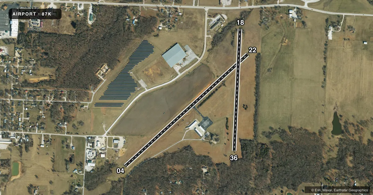
Runways & pattern
Full pagePattern entry · RWY 22
LEFT TRAFFIC| Runway | Heading (°M) | Length | Surface | Traffic |
|---|---|---|---|---|
| 04/22Favored | 42° / 222° | 3,295 ft | ASPH | Standard L |
| 18/36 | 178° / 358° | 2,430 ft | TURF | Standard L |
Runway end performance
| End | TORA | TODA | ASDA | LDA | VGSI | Approach lights | Obstruction |
|---|---|---|---|---|---|---|---|
| 04 | — | — | — | — | — | — | 45', trees, 239' from thr, 117' R of cntrln, slope 0 |
| 18 | — | — | — | — | — | — | 22', trees, 0' from thr, 0' R of cntrln, slope 0 |
| 36 | — | — | — | — | — | — | 30', trees, 0' from thr, 75' R of cntrln, slope 0 |
Declared distances in feet. TORA = takeoff run available, TODA = takeoff distance, ASDA = accelerate-stop, LDA = landing distance.
Airport sketch
Runways drawn to scale from FAA survey coordinates, rendered over satellite imagery. Not for navigation.
Approaches & charts
Services on the field
Fuel grades, oxygen, maintenance, ramp storage and lighting — as declared to the FAA by the airport operator.
Fuel & services
- Fuel
- Not available
- Oxygen (bottled)
- Not available
- Oxygen (bulk)
- Not available
- Airframe repair
- Minor
- Power plant repair
- Minor
- Other services
- INSTR
Ramp & ground
- Transient storage
- Tie-down
- Landing fee
- No fee published
- Lighting schedule
- SEE RMK
- Beacon schedule
- SS-SR
- Beacon
- White / Green (civil land)(WG)
- Wind indicator
- Lighted
- Segmented circle
- No
Fuel & FBOs
Cheapest 100LL and Jet A on the field and nearby. Always confirm with the FBO before taxi.
Airport notes
Surface conditions, obstructions, local procedures, lighting outages and other notes published with each FAA cycle.
General notes
- WILDLIFE ON & INVOF ARPT.
- INSUF RWY SAFETY AREA LENGTH BYND EACH END OF RWY 18/36. TREES WITHIN RWY SAFETY AREA AT EACH END OF RWY 18/36.
- FOR CD CTC KANSAS CITY ARTCC AT 913-254-8508.
Lighting notes
- ACTVT MIRL RY 04/22 - CTAF.
Other notes
- 1MANAGER LIVES ON AIRPORT.
VFR map & nearby airports
VFR sectional. Tap any ICAO chip to open that airport.
Key facts · 87K
Answer card- ICAO
- 87K
- Name
- EL DORADO SPRINGS MEML
- Location
- EL DORADO SPRINGS, MISSOURI
- Elevation
- 931.4 ft MSL
- Traffic pattern altitude
- 1,931.4 ft MSL (1,000 AGL)
- Control tower
- Non-towered (use CTAF)
- Total runways
- 2
- Longest runway
- 04/22 · 3,295 ft
- Published ILS approaches
- 0
- Published frequencies
- 2
- Magnetic variation
- 5°
- Current flight rules
- VFR
- Current wind
- 210° at 9 kt
- Favored runway now
- RWY 22
El Dorado Springs Meml (87K) sits in El Dorado Springs, Missouri. Field elevation is 931.4 ft MSL. The airport has two runways. The longest is runway 04/22 at 3,295 ft. Runway 18/36 is 2,430 ft of turf. There is no control tower. CTAF and UNICOM are both 122.8. No ILS approaches are published.
Pattern altitude is not published. Use the standard 1,000 ft AGL pattern for light piston operations unless the current Chart Supplement says otherwise. That puts the pattern at about 1,931 ft MSL based on the field elevation, but confirm before you go.
There are no on-field FBOs listed. Contact the airport operator directly before arrival, or call the field on CTAF or UNICOM for current fuel and service availability. Published remarks matter here. Trees sit within the runway safety area at both ends of runway 18/36. Wildlife is also reported on and near the airport. Runway 04/22 has medium intensity lights that are activated by using the common traffic advisory frequency. If you need clearance delivery, Kansas City Center handles it. This is a non-towered field, so plan your self-announce calls early and keep an eye out on final and in the pattern.