METAR & TAF KBUM
KBUM does not publish a METAR.
Showing the nearest reporting station: KLRY (LAWRENCE SMITH MEML) · 19.2 NM away. Conditions at KBUM may differ.
METAR · KLRY
Observed 13:35Z
KLRY 271335Z AUTO 21005KT 10SM CLR 29/22 A2992 RMK AO2
- Wind
- 210° @ 5 kt
- Visibility
- 10 SM
- Temp / Dew
- 29°C / 22°C
- Altimeter
- 29.92 inHg
- Clouds
- CLR
- Density alt
- 2,788 ft
- Ceiling
- Unlimited
- Rules
- VFR
Airport info & contacts
Manager on record, flight service, ARTCC, attendance schedule and pattern altitude — published by the FAA and refreshed every 28 days.
Location
- From city
- 2 NM N
- VFR sectional
- KANSAS CITY
- ARTCC
- ZKC · KANSAS CITY
- NOTAM facility
- COU (NOTAM-D)
Airport manager
- Name
- DENNIS JACOBS
- Phone
- 660-424-0620
- Address
- 107 W OHIO STREET, BUTLER MO 64730
Flight service · Hours
- FSS COU
- COLUMBIA1-800-WX-BRIEF
- Attendance
- ALL
Frequencies
Tap any row to copy the frequency to your clipboard.
Runways & pattern
Full pagePattern entry · RWY 18
LEFT TRAFFICRunway end performance
| End | TORA | TODA | ASDA | LDA | VGSI | Approach lights | Obstruction |
|---|---|---|---|---|---|---|---|
| 18 | — | — | — | — | PAPI 2-box left(2.9°) | — | — |
| 36 | — | — | — | — | PAPI 2-box left(2.9°) | — | — |
Declared distances in feet. TORA = takeoff run available, TODA = takeoff distance, ASDA = accelerate-stop, LDA = landing distance.
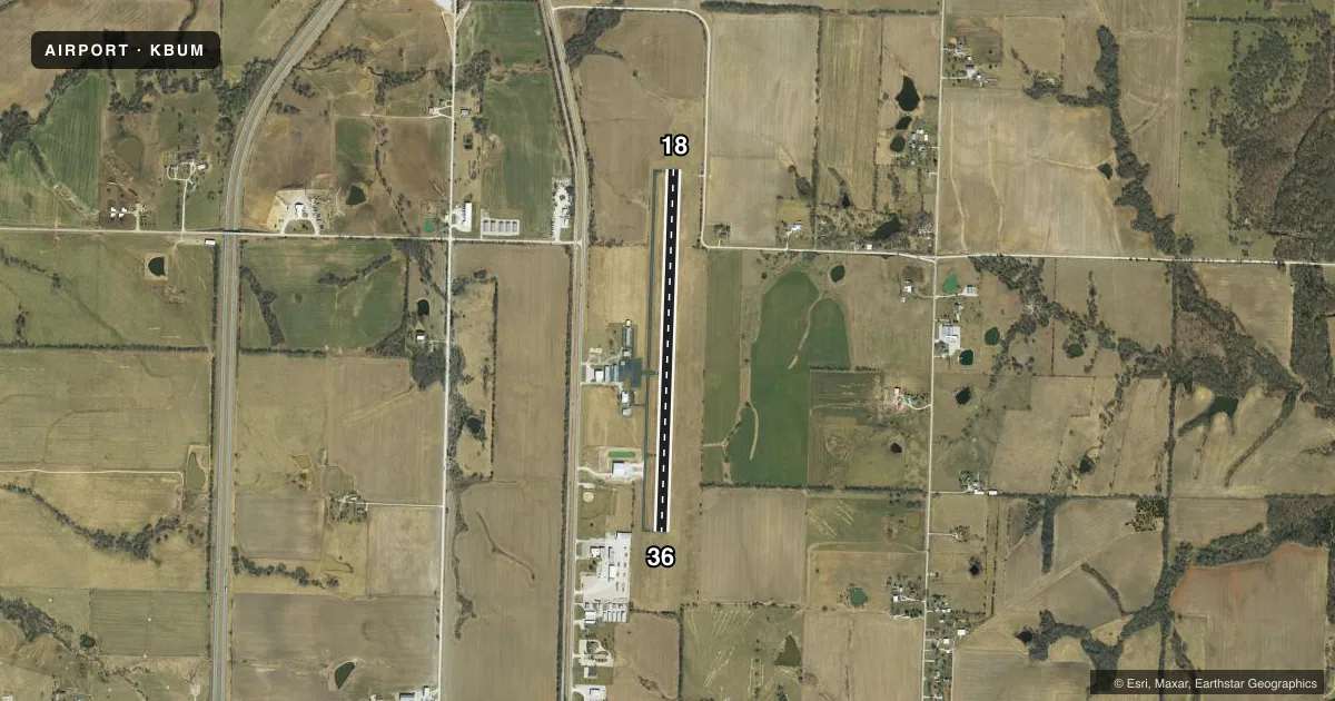
Airport sketch
Runways drawn to scale from FAA survey coordinates, rendered over satellite imagery. Not for navigation.
Approaches & charts
Services on the field
Fuel grades, oxygen, maintenance, ramp storage and lighting — as declared to the FAA by the airport operator.
Fuel & services
- Fuel
- 100LL
- Oxygen (bottled)
- Not available
- Oxygen (bulk)
- Not available
- Airframe repair
- Minor
- Power plant repair
- Minor
- Other services
- AGRI,INSTR,PAJA,RNTL
Ramp & ground
- Transient storage
- Tie-down
- Landing fee
- No fee published
- Customs
- Not available
- Lighting schedule
- SS-SR
- Beacon schedule
- SS-SR
- Beacon
- White / Green (civil land)(WG)
- Wind indicator
- Lighted
- Segmented circle
- No
Fuel & FBOs
Cheapest 100LL and Jet A on the field and nearby. Always confirm with the FBO before taxi.
Airport notes
Surface conditions, obstructions, local procedures, lighting outages and other notes published with each FAA cycle.
General notes
- ULTRALIGHTS ON & INVOF ARPT.
- TWO TWRS +195 FT & +411 FT; APRXLY 7000 FT & 14000 FT S OF RY 36 THLD.
- FOR CD IF UNA TO CTC ON FSS FREQ, CTC KANSAS CITY ARTCC AT 913-254-8508.
VFR map & nearby airports
VFR sectional. Tap any ICAO chip to open that airport.
Key facts · KBUM
Answer card- ICAO
- KBUM
- Name
- BUTLER MEML
- Location
- BUTLER, MISSOURI
- Elevation
- 893.7 ft MSL
- Traffic pattern altitude
- 1,893.7 ft MSL (1,000 AGL)
- Control tower
- Non-towered (use CTAF)
- Total runways
- 1
- Longest runway
- 18/36 · 3,999 ft
- Published ILS approaches
- 0
- Published frequencies
- 1
- Magnetic variation
- 4°
- Current flight rules
- VFR
- Current wind
- 210° at 5 kt
- Favored runway now
- RWY 18
Butler Memorial Airport (KBUM) sits in Butler, Missouri. The field elevation is 893.7 ft MSL. It has one runway. Runway 18/36 is 3,999 ft long with an asphalt surface. The airport is non-towered, so pilots should plan for self-announced traffic on CTAF 122.9.
No ILS approaches are published here. The pattern altitude is not published in the facts, so use the standard 1,000 ft AGL pattern unless current airport information says otherwise. Skydive Kansas City is on the field. It carries AVGAS 100LL. Ultralight aircraft also operate on and near the airport, so expect mixed traffic and keep a sharp scan in the pattern.
Two tall towers are reported south of runway 36. One is about 7,000 ft south of the threshold. The other is about 14,000 ft south. That matters on departure and on any low work south of the field. If you need clearance delivery and cannot reach Flight Service, the published remark says to contact Kansas City ARTCC at 913-254-8508. Check the current FAA Chart Supplement before flight for any updates to remarks, traffic flow, or local procedures.