METAR & TAF KLRY
Current METAR
Observed 18:55Z
KLRY 271855Z AUTO 20007KT 10SM CLR 36/22 A2986 RMK AO2
- Wind
- 200° @ 7 kt
- Visibility
- 10 SM
- Temp / Dew
- 36°C / 22°C
- Altimeter
- 29.86 inHg
- Clouds
- CLR
- Density alt
- 3,729 ft
- Ceiling
- Unlimited
- Rules
- VFR
Airport info & contacts
Manager on record, flight service, ARTCC, attendance schedule and pattern altitude — published by the FAA and refreshed every 28 days.
Location
- From city
- 3 NM S
- VFR sectional
- KANSAS CITY
- ARTCC
- ZKC · KANSAS CITY
- NOTAM facility
- COU (NOTAM-D)
Airport manager
- Name
- MICHAEL NEWMAN
- Phone
- (660) 422-2090
- Address
- PO BOX 367, HARRISONVILLE MO 64701
Flight service · Hours
- FSS COU
- COLUMBIA1-800-WX-BRIEF
- Attendance
- MON-FRI · 0800-1700
- SAT-SUN · IREG
Frequencies
Tap any row to copy the frequency to your clipboard.
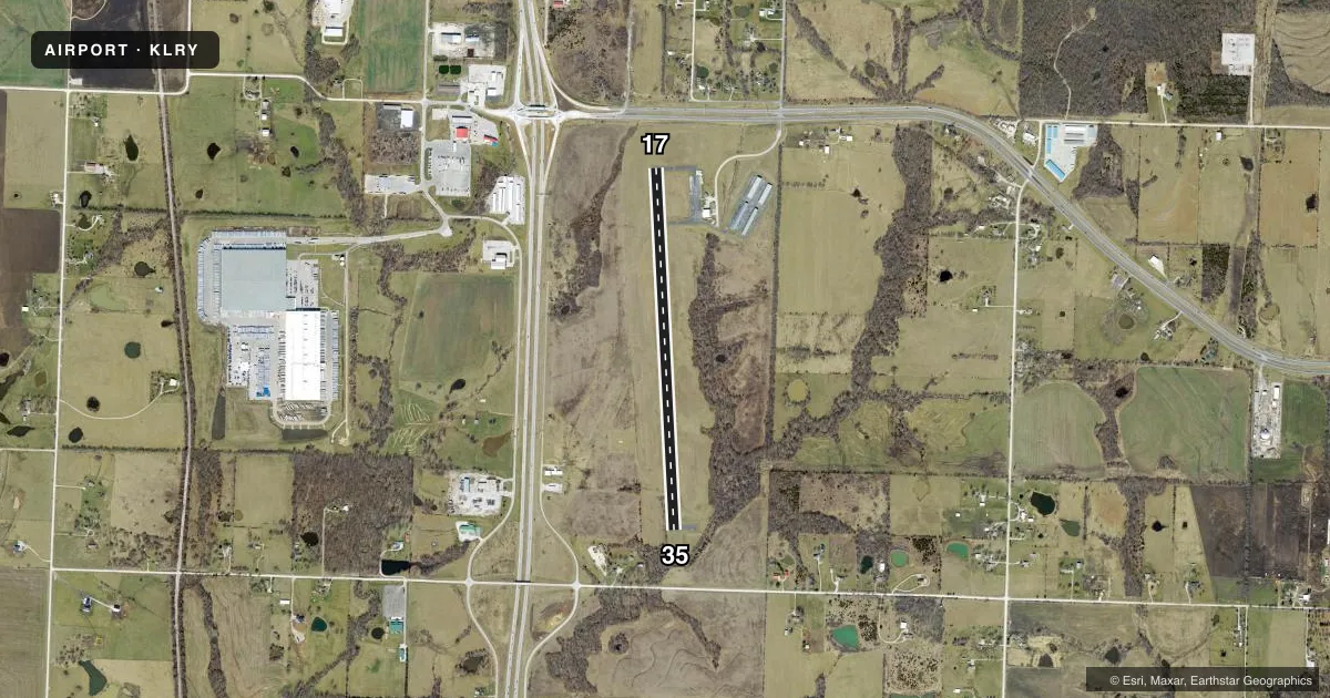
Runways & pattern
Full pagePattern entry · RWY 17
LEFT TRAFFICRunway end performance
| End | TORA | TODA | ASDA | LDA | VGSI | Approach lights | Obstruction |
|---|---|---|---|---|---|---|---|
| 17 | 4,000' | 4,000' | 4,000' | 4,000' | PAPI 2-box left(4°) | — | 73', trees, 1115' from thr, 335' R of cntrln, slope 12 |
| 35 | 4,000' | 4,000' | 4,000' | 4,000' | PAPI 2-box left(3°) | — | 27', trees, 340' from thr, 200' R of cntrln, slope 5 |
Declared distances in feet. TORA = takeoff run available, TODA = takeoff distance, ASDA = accelerate-stop, LDA = landing distance.
Airport sketch
Runways drawn to scale from FAA survey coordinates, rendered over satellite imagery. Not for navigation.
Approaches & charts
Services on the field
Fuel grades, oxygen, maintenance, ramp storage and lighting — as declared to the FAA by the airport operator.
Fuel & services
- Fuel
- 100LL
- Oxygen (bottled)
- Not available
- Oxygen (bulk)
- Not available
- Airframe repair
- Minor
- Power plant repair
- Minor
- Other services
- AGRI,AMB,INSTR,RNTL
Ramp & ground
- Transient storage
- Tie-down
- Landing fee
- No fee published
- Customs
- Not available
- Lighting schedule
- SEE RMK
- Beacon schedule
- SS-SR
- Beacon
- White / Green (civil land)(WG)
- Wind indicator
- Lighted
- Segmented circle
- Yes
Fuel & FBOs
Cheapest 100LL and Jet A on the field and nearby. Always confirm with the FBO before taxi.
Airport notes
Surface conditions, obstructions, local procedures, lighting outages and other notes published with each FAA cycle.
General notes
- ULTRALIGHTS ON & INVOF ARPT.
- AIR AMBULANCE HELICOPTER OPS ON AND INVOF ARPT.
- FOR CD CTC KANSAS CITY APCH AT 816-329-2710.
- DEER AND OTHER WILDFLIFE ON AND INVOF ARPT.
Lighting notes
- ACTVT REIL RWY 17 & 35; PAPI RWY 17 & 35; MIRL RWY 17/35 - CTAF.
Fuel notes
- 100LL24-HR SELF SVC FUEL.
VFR map & nearby airports
VFR sectional. Tap any ICAO chip to open that airport.
Key facts · KLRY
Answer card- ICAO
- KLRY
- Name
- LAWRENCE SMITH MEML
- Location
- HARRISONVILLE, MISSOURI
- Elevation
- 915.4 ft MSL
- Traffic pattern altitude
- 1,915.4 ft MSL (1,000 AGL)
- Control tower
- Non-towered (use CTAF)
- Total runways
- 1
- Longest runway
- 17/35 · 4,000 ft
- Published ILS approaches
- 0
- Published frequencies
- 1
- Magnetic variation
- 4°
- Current flight rules
- VFR
- Current wind
- 200° at 7 kt
- Favored runway now
- RWY 17
Lawrence Smith Memorial Airport (KLRY) sits near Harrisonville, Missouri. Field elevation is 915.4 ft MSL. The airport has one runway, 17/35, which is 4,000 ft long with concrete pavement. There is no control tower. CTAF is 122.9. No ILS approaches are published here, so plan with the current chart and weather in mind before you go.
Pattern altitude is not published. Use 1,000 ft AGL for light piston traffic unless the current FAA Chart Supplement or local procedures say otherwise. The field has 24-hour self-service 100LL available through Lawrence Smith Memorial Airport. Runway end identifier lights are active on 17 and 35. PAPI is installed on both ends. Medium intensity runway lights are controlled on CTAF.
A first-time pilot should pay attention to wildlife. Deer and other animals are reported on and near the airport. Air ambulance helicopter traffic also operates here. Ultralights are active in the area too. For clearance delivery, Kansas City Approach is listed in the remarks. If you need current operating details before departure, verify them with the airport operator or the current FAA Chart Supplement.