METAR & TAF 3GV
3GV does not publish a METAR.
Showing the nearest reporting station: KLXT (KANSAS CITY/LEE'S SUMMIT RGNL) · 8.1 NM away. Conditions at 3GV may differ.
METAR · KLXT
Observed 15:53Z
KLXT 271553Z AUTO 20012G20KT 10SM CLR 32/22 A2986 RMK AO2 SLP098 T03220222
- Wind
- 200° @ 12G20 kt
- Visibility
- 10 SM
- Temp / Dew
- 32°C / 22°C
- Altimeter
- 29.86 inHg
- Clouds
- CLR
- Density alt
- 3,150 ft
- Ceiling
- Unlimited
- Rules
- VFR
Airport info & contacts
Manager on record, flight service, ARTCC, attendance schedule and pattern altitude — published by the FAA and refreshed every 28 days.
Location
- VFR sectional
- KANSAS CITY
- ARTCC
- ZKC · KANSAS CITY
- NOTAM facility
- COU (NOTAM-D)
Airport manager
- Name
- DAN WILLIAMS
- Phone
- 816-286-9206
- Address
- BOX 255, 600 EE KIRBY RD, GRAIN VALLEY MO 64029
Flight service · Hours
- FSS COU
- COLUMBIA1-800-WX-BRIEF
- Attendance
- 0800-DUSK
Frequencies
Tap any row to copy the frequency to your clipboard.
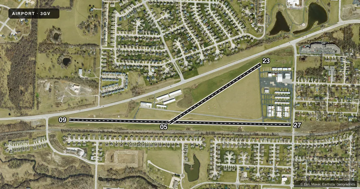
Runways & pattern
Full pagePattern entry · RWY 23
RIGHT TRAFFIC| Runway | Heading (°M) | Length | Surface | Traffic |
|---|---|---|---|---|
| 09/27 | 88° / 268° | 4,507 ft | ASPH | 09 R |
| 05/23Favored | 54° / 234° | 2,206 ft | ASPH | 23 R |
Runway end performance
| End | TORA | TODA | ASDA | LDA | VGSI | Approach lights | Obstruction |
|---|---|---|---|---|---|---|---|
| 09 | — | — | — | — | — | — | 23', rr, 201' from thr, 200' R of cntrln, slope 1 |
| 27 | — | — | — | — | — | — | 15', rr, 201' from thr, 175' R of cntrln, slope 1 |
| 05 | — | — | — | — | — | — | 32', trees, 230' from thr, 90' R of cntrln, slope 1 |
| 23 | — | — | — | — | — | — | 56', trees, 656' from thr, 207' R of cntrln, slope 8 |
Declared distances in feet. TORA = takeoff run available, TODA = takeoff distance, ASDA = accelerate-stop, LDA = landing distance.
Airport sketch
Runways drawn to scale from FAA survey coordinates, rendered over satellite imagery. Not for navigation.
Approaches & charts
Services on the field
Fuel grades, oxygen, maintenance, ramp storage and lighting — as declared to the FAA by the airport operator.
Fuel & services
- Fuel
- 100LL
- Oxygen (bottled)
- Not available
- Oxygen (bulk)
- Not available
- Airframe repair
- Major
- Power plant repair
- Major
- Other services
- INSTR,RNTL
Ramp & ground
- Transient storage
- Tie-down
- Hangar
- Landing fee
- No fee published
- Customs
- Not available
- Lighting schedule
- SEE RMK
- Beacon schedule
- SS-SR
- Beacon
- White / Green (civil land)(WG)
- Wind indicator
- Lighted
- Segmented circle
- No
Fuel & FBOs
Cheapest 100LL and Jet A on the field and nearby. Always confirm with the FBO before taxi.
Airport notes
Surface conditions, obstructions, local procedures, lighting outages and other notes published with each FAA cycle.
General notes
- WATERFOWL ON & INVOF ARPT.
- NTSD RWY SAFETY AREA ALL RWY ENDS; INSUFFICIENT LENS & INCOR TRRN GRADES; NO RWY SAFETY AREA BYD RWY 05 & 27.
- FOR CD CTC KANSAS CITY APCH AT 816-329-2710.
Lighting notes
- ACTVT REIL RWY 09; MIRL RWY 09/27 - CTAF.
Runway surface & condition
- 05/23RWY 05/23 STEEP GRADE 60-235 FT NE OF RWY 05 THLD.
- 09/27NSTD MIRL; NO YELLOW EDGE LGTS LAST 2000 FT BOTH ENDS; ALL EDGE LGTS LCTD 13-15 FT FM PAVEMENT EDGE; RWY 27 ONLY 6 THR LGTS LCTD 18-20 FT E OF THR.
- 05/23WIDTH VARIANCE 20-25 FT.
- 09/27WIDTH VARIANCE 44-45 FT.
Approach & departure obstructions
- 05RR TRACK 0-200 FT FROM RWY, 80-230 FT RIGHT; TREES 20-35 FT, 0-200 FT FROM RWY, 130-250 FT RIGHT.
- 09RWY 09 1-20 FT GND 0-200 FT FM RWY END LEFT & RIGHT; +16 FT SIGNS 145 FT FM RWY END 80 FT LEFT; 10-25 FT ROAD 0-200 FT FM RWY END 125-160 FT LEFT; +1-50 FT TREES & RR 0-200 FT FM RWY END 200-250 FT RIGHT.
- 23HNGR BLDG 16-26 FT, 125-200 FT FM RWY END, 180-250 FT LEFT.
- 27+1-33 FT BRUSH; TREES; FENCE; RR; ROAD & BLDGS 0-200 FT FM RWY END LEFT & RIGHT.
- 090:1 TO DSPLCD THLD; +1-5 FT GND 0-90 FT FM RWY END 70-130 FT RIGHT.
Other notes
- E111 PRVDD E/W RWY IS ABDND UPON ACTVTN OF NEW E/W (09/27) RWY; APCH TO EACH RWY IS MAINTD FOR A MIN 20:1 GS & TRSNL SFC MAINTD FOR A 7:1 SLOPE.
- WIND SOCK
VFR map & nearby airports
VFR sectional. Tap any ICAO chip to open that airport.
Key facts · 3GV
Answer card- ICAO
- 3GV
- Name
- EAST KANSAS CITY
- Location
- GRAIN VALLEY, MISSOURI
- Elevation
- 835 ft MSL
- Traffic pattern altitude
- 1,835 ft MSL (1,000 AGL)
- Control tower
- Non-towered (use CTAF)
- Total runways
- 2
- Longest runway
- 09/27 · 4,507 ft
- Published ILS approaches
- 0
- Published frequencies
- 5
- Magnetic variation
- 3°
- Current flight rules
- VFR
- Current wind
- 200° at 12 kt
- Favored runway now
- RWY 23
East Kansas City (3GV) sits in Grain Valley, Missouri. Field elevation is 835 ft MSL. The airport has two asphalt runways. The longest is 09/27 at 4,507 ft. There is no control tower, so plan on CTAF and UNICOM use for local traffic flow. No ILS approaches are published here.
Pattern altitude is not published. Use the standard 1,000 ft AGL pattern unless the current FAA Chart Supplement or local procedures say otherwise. The field is in the Kansas City area, so expect to stay sharp on radio work and traffic awareness. Clearance delivery is handled through Kansas City Approach at 816-329-2710. The published frequencies include CTAF and UNICOM on 122.8. Kansas City Approach and departure use 118.4 and 307.35. CD/P is 121.3.
Grain Valley Airport is the on-field FBO. It carries AVGAS 100LL. Published remarks matter here. Runway 09/27 has nonstandard medium intensity lighting. The runway edge lights are set inboard from the pavement edge. The last 2,000 ft do not have yellow edge lights. Runway 05 has close-in railroad tracks and trees near the approach end. Runway safety areas are not standard at all ends. Waterfowl are also reported on and near the airport. A first-time pilot should review the runway layout, the lighting notes and the obstruction picture before arrival.