METAR & TAF 3EX
3EX does not publish a METAR.
Showing the nearest reporting station: KGPH (MIDWEST NTL AIR CENTER) · 5.2 NM away. Conditions at 3EX may differ.
METAR · KGPH
Observed 13:15Z
KGPH 271315Z AUTO 21005KT 10SM CLR 28/22 A2985 RMK AO2
- Wind
- 210° @ 5 kt
- Visibility
- 10 SM
- Temp / Dew
- 28°C / 22°C
- Altimeter
- 29.85 inHg
- Clouds
- CLR
- Density alt
- 2,886 ft
- Ceiling
- Unlimited
- Rules
- VFR
Airport info & contacts
Manager on record, flight service, ARTCC, attendance schedule and pattern altitude — published by the FAA and refreshed every 28 days.
Location
- From city
- 1 NM E
- VFR sectional
- KANSAS CITY
- ARTCC
- ZKC · KANSAS CITY
- NOTAM facility
- COU (NOTAM-D)
Airport manager
- Name
- JERRY BEEBE, DON MYERS
- Phone
- (816) 678-3667
- Address
- 1400 S. MARIETTA, EXCELSIOR SPRINGS MO 64024
Flight service · Hours
- FSS COU
- COLUMBIA1-800-WX-BRIEF
- Attendance
- Unattended
Frequencies
Tap any row to copy the frequency to your clipboard.
Runways & pattern
Full pagePattern entry · RWY 21
LEFT TRAFFICRunway end performance
| End | TORA | TODA | ASDA | LDA | VGSI | Approach lights | Obstruction |
|---|---|---|---|---|---|---|---|
| 03 | — | — | — | — | — | — | 27', trees, 225' from thr, 145' R of cntrln, slope 0 |
| 21 | — | — | — | — | — | — | 72', trees, 702' from thr, 215' R of cntrln, slope 6 |
Declared distances in feet. TORA = takeoff run available, TODA = takeoff distance, ASDA = accelerate-stop, LDA = landing distance.
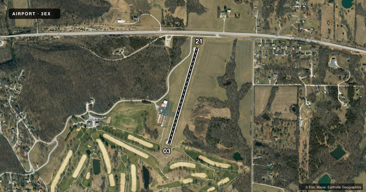
Airport sketch
Runways drawn to scale from FAA survey coordinates, rendered over satellite imagery. Not for navigation.
Approaches & charts
Services on the field
Fuel grades, oxygen, maintenance, ramp storage and lighting — as declared to the FAA by the airport operator.
Fuel & services
- Fuel
- Not available
- Oxygen (bottled)
- Not available
- Oxygen (bulk)
- Not available
- Other services
- INSTR,RNTL
Ramp & ground
- Transient storage
- Tie-down
- Landing fee
- No fee published
- Customs
- Not available
- Beacon schedule
- SS-SR
- Beacon
- White / Green (civil land)(WG)
- Wind indicator
- Lighted
- Segmented circle
- Yes
Fuel & FBOs
Cheapest 100LL and Jet A on the field and nearby. Always confirm with the FBO before taxi.
Airport notes
Surface conditions, obstructions, local procedures, lighting outages and other notes published with each FAA cycle.
General notes
- WILDLIFE ON & INVOF ARPT.
- FOR CD CTC KANSAS CITY APCH AT 816-329-2710.
Runway surface & condition
- 03/21NSTD LIRL; INCOR SPACING AND COLOR OF LGTS.
Approach & departure obstructions
- 0370 FT TREE 170 FT FM RWY END AND 160 FT LEFT; 40 FT TREE 10 FT FM RWY END AND 230 FT RIGHT.
- 21+1-10 FT ROAD 0-200 FT FM RWY END 120-160 FT R.
Other notes
- EXISTED PRIOR TO 1959.
- MANAGER(816) 682-3764
VFR map & nearby airports
VFR sectional. Tap any ICAO chip to open that airport.
Key facts · 3EX
Answer card- ICAO
- 3EX
- Name
- EXCELSIOR SPRINGS MEML
- Location
- EXCELSIOR SPRINGS, MISSOURI
- Elevation
- 999.6 ft MSL
- Traffic pattern altitude
- 1,999.6 ft MSL (1,000 AGL)
- Control tower
- Non-towered (use CTAF)
- Total runways
- 1
- Longest runway
- 03/21 · 2,004 ft
- Published ILS approaches
- 0
- Published frequencies
- 4
- Magnetic variation
- 1°
- Current flight rules
- VFR
- Current wind
- 210° at 5 kt
- Favored runway now
- RWY 21
Excelsior Springs Meml (3EX) sits in Excelsior Springs, Missouri. Field elevation is 999.6 ft MSL. The airport has one runway, 03/21, which is 2,004 ft long. There is no control tower. No ILS approaches are published here.
Pattern altitude is not published. Use 1,000 ft AGL for light piston operations unless the current Chart Supplement says otherwise. With the field sitting near 1,000 ft MSL, that puts the standard pattern around 2,000 ft MSL.
CTAF and UNICOM are both 122.7. Kansas City Approach is listed on 118.4 and 307.35. For clearance delivery, contact Kansas City Approach at 816-329-2710. There are no on-field FBOs listed, so verify fuel and services with the airport operator or the FBO directly by phone before you go.
Published remarks matter here. Runway 03/21 has nonstandard low-intensity lights with incorrect spacing and color. Wildlife has been reported on and near the airport. There are also obstructions near both runway ends. A road sits near the 21 end. Trees are near the 03 end. That makes a careful taxi, takeoff and landing brief a good idea before arrival.