METAR & TAF 0N0
0N0 does not publish a METAR.
Showing the nearest reporting station: KGPH (MIDWEST NTL AIR CENTER) · 6.7 NM away. Conditions at 0N0 may differ.
METAR · KGPH
Observed 20:55Z
KGPH 272055Z AUTO 21006KT 10SM CLR 37/22 A2977 RMK AO2
- Wind
- 210° @ 6 kt
- Visibility
- 10 SM
- Temp / Dew
- 37°C / 22°C
- Altimeter
- 29.77 inHg
- Clouds
- CLR
- Density alt
- 4,071 ft
- Ceiling
- Unlimited
- Rules
- VFR
Airport info & contacts
Manager on record, flight service, ARTCC, attendance schedule and pattern altitude — published by the FAA and refreshed every 28 days.
Location
- From city
- 3 NM NW
- VFR sectional
- KANSAS CITY
- ARTCC
- ZKC · KANSAS CITY
- NOTAM facility
- COU (NOTAM-D)
Airport manager
- Name
- PAUL STUBER
- Phone
- 816-781-7194
- Address
- 11001 NE 112TH ST., KANSAS CITY MO 64057
Flight service · Hours
- FSS COU
- COLUMBIA1-800-WX-BRIEF
- Attendance
- 0800-DUSK
Frequencies
Tap any row to copy the frequency to your clipboard.
Runways & pattern
Full pagePattern entry · RWY 18
LEFT TRAFFICRunway end performance
| End | TORA | TODA | ASDA | LDA | VGSI | Approach lights | Obstruction |
|---|---|---|---|---|---|---|---|
| 18 | — | — | — | — | — | — | 62', trees, 505' from thr, 150' R of cntrln, slope 4 |
| 36 | — | — | — | — | — | — | 26', trees, 482' from thr, 150' R of cntrln, slope 10 |
Declared distances in feet. TORA = takeoff run available, TODA = takeoff distance, ASDA = accelerate-stop, LDA = landing distance.
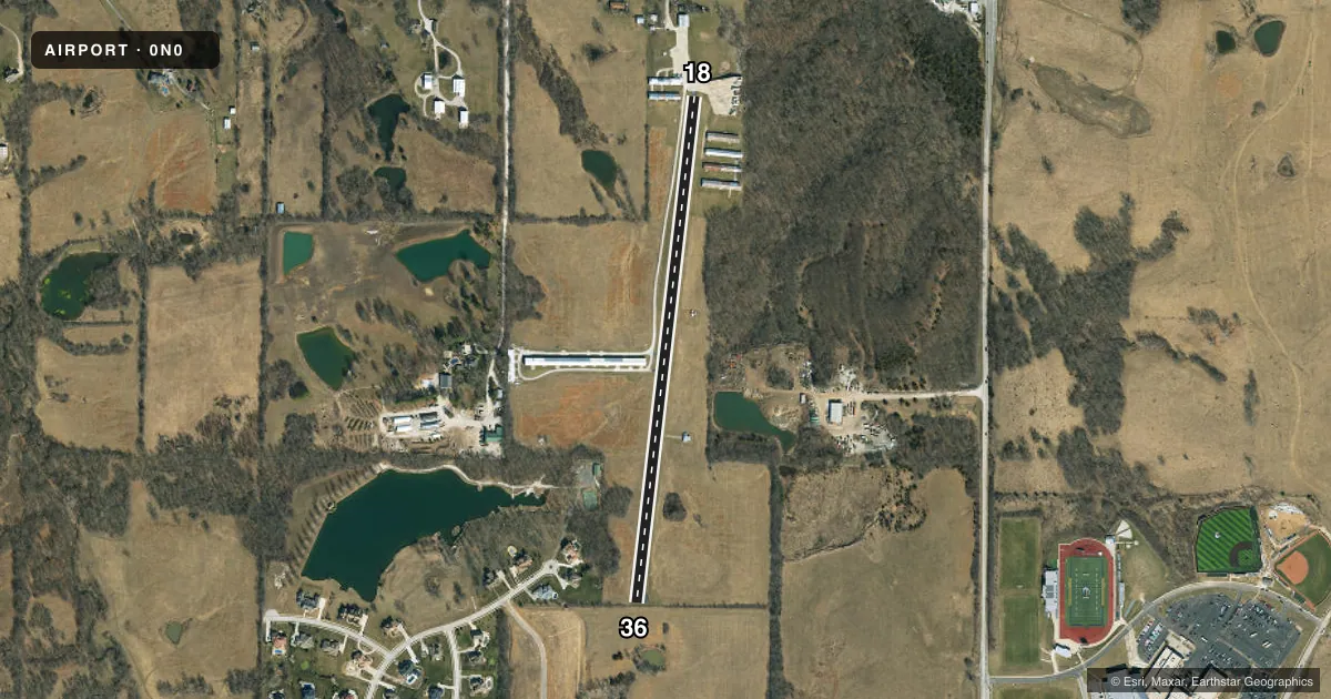
Airport sketch
Runways drawn to scale from FAA survey coordinates, rendered over satellite imagery. Not for navigation.
Approaches & charts
Services on the field
Fuel grades, oxygen, maintenance, ramp storage and lighting — as declared to the FAA by the airport operator.
Fuel & services
- Fuel
- 100LL
- Oxygen (bottled)
- Not available
- Oxygen (bulk)
- Not available
- Airframe repair
- Major
- Power plant repair
- Major
- Other services
- INSTR,RNTL
Ramp & ground
- Transient storage
- Tie-down
- Landing fee
- No fee published
- Customs
- Not available
- Lighting schedule
- SEE RMK
- Wind indicator
- Yes
- Segmented circle
- No
Fuel & FBOs
Cheapest 100LL and Jet A on the field and nearby. Always confirm with the FBO before taxi.
Airport notes
Surface conditions, obstructions, local procedures, lighting outages and other notes published with each FAA cycle.
General notes
- WILDLIFE ON & INVOF RY ESPECIALLY EARLY MORNING HRS.
- NSTD RY SAFETY AREAS BEYOND BOTH RY ENDS; RY 18 END LARGE DROP OFF; RY 36 HAS 4 FT FENCE 15 FT FM RY END.
- FOR CD CTC KANSAS CITY APCH AT 816-329-2710.
Lighting notes
- ACTVT MIRL RY 18/36 - CTAF.
Runway surface & condition
- 18/36FIRST 50 FT ON NORTH END STEEP SLOPE; RY ALNMT CROOKED.
- 18/36NSTD MIRL; LGTS 40-50 FT LEFT & RIGHT OF CNTRLN AT 100 FT DSTCS ON WEST SIDE; VARIOUS DSTCS ON EAST SIDE; 2 RED THLD LGTS AT EACH THLD.
Approach & departure obstructions
- 18RWY 18 1-20 FT GND; BLDGS & AUTO PARKING AREA 0-200 FT FM RY END, 10-125 FT R.
- 36RWY 36 +1-4 FT GND & FC 25-30 FT FROM RY END L & R.
- 18RWY 18 NSTD NPI MARKINGS; SMALL NR DESIGNATIONS, THLD MARKINGS, & DASHED CNTRLN.
- 36RWY 36 NSTD BASIC MARKINGS; SMALL NR DESIGNATIONS & DASHED CNTRLN.
Other notes
- PRVDD THE APCH TO EACH RWY IS MAINTD FOR A MIN 20:1 GLIDE SLOPE & THE TRANSITIONAL SFC BE MAINTD FOR A 7:1.
- 1FOR ATTENDANT OTHER HRS CALL 816-781-4326.
VFR map & nearby airports
VFR sectional. Tap any ICAO chip to open that airport.
Key facts · 0N0
Answer card- ICAO
- 0N0
- Name
- ROOSTERVILLE
- Location
- LIBERTY, MISSOURI
- Elevation
- 1,004 ft MSL
- Traffic pattern altitude
- 2,004 ft MSL (1,000 AGL)
- Control tower
- Non-towered (use CTAF)
- Total runways
- 1
- Longest runway
- 18/36 · 2,780 ft
- Published ILS approaches
- 0
- Published frequencies
- 2
- Magnetic variation
- 5°
- Current flight rules
- VFR
- Current wind
- 210° at 6 kt
- Favored runway now
- RWY 18
Roosterville Airport sits in Liberty, Missouri. The field elevation is 1,004 ft MSL. It has one runway, 18/36, which is 2,780 ft long and asphalt. There is no control tower. CTAF and UNICOM are both 122.8. No ILS approaches are published here.
The pattern altitude is not published. Use the standard 1,000 ft AGL for light piston operations unless the current Chart Supplement says otherwise. That puts the pattern at 2,004 ft MSL based on the listed field elevation. Runway lighting is medium intensity and is activated by the CTAF. The remarks also note nonstandard runway markings, a crooked alignment and a steep slope on the north end of the runway. Runway 18 has nearby ground obstructions. Buildings and a parking area are close to the departure end. Runway 36 has fence and ground obstructions near the end. Wildlife is also reported on and near the runway, especially early in the morning.
There are no on-field FBOs listed in the facts. Contact the airport operator directly before arrival. You can also call the field on CTAF or UNICOM for current FBO availability. For clearance delivery, contact Kansas City Approach at 816-329-2710. Pilots should plan for a non-towered arrival with close attention to runway condition, slope and the published obstruction notes.