METAR & TAF KFLV
KFLV does not publish a METAR.
Showing the nearest reporting station: KMCI (KANSAS CITY INTL) · 10.2 NM away. Conditions at KFLV may differ.
METAR · KMCI
Observed 14:53Z
KMCI 271453Z 21012G18KT 10SM FEW250 31/22 A2983 RMK AO2 SLP089 T03060222 58004
- Wind
- 210° @ 12G18 kt
- Visibility
- 10 SM
- Temp / Dew
- 31°C / 22°C
- Altimeter
- 29.83 inHg
- Clouds
- FEW
- Density alt
- 2,988 ft
- Ceiling
- Unlimited
- Rules
- VFR
Airport info & contacts
Manager on record, flight service, ARTCC, attendance schedule and pattern altitude — published by the FAA and refreshed every 28 days.
Location
- From city
- 3 NM N
- VFR sectional
- KANSAS CITY
- Pattern altitude
- 698 ft AGL · 1,469 ft MSL
- ARTCC
- ZKC · KANSAS CITY
- NOTAM facility
- ICT (NOTAM-D)
Airport manager
- Name
- AIRFIELD OPS
- Phone
- 913-684-6040
- Address
- 1000 CHIEF JOSEPH LOOP, FT. LEAVENWORTH KS 66027-1254
Flight service · Hours
- FSS ICT
- WICHITA1-800-WX-BRIEF
- Attendance
- M-F · 0730-1630 (MIL)
- 0900-1800 (GA)
Frequencies
Tap any row to copy the frequency to your clipboard.
Runways & pattern
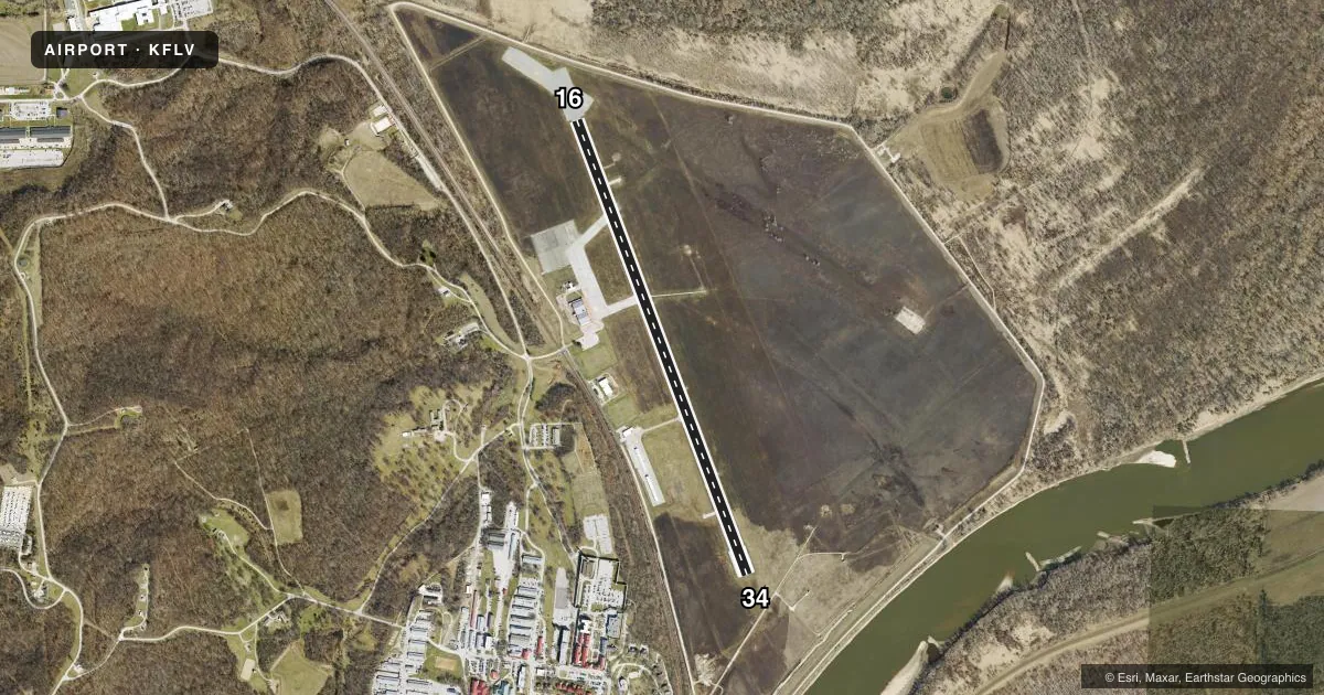
Full pagePattern entry · RWY 16
LEFT TRAFFICRunway end performance
| End | TORA | TODA | ASDA | LDA | VGSI | Approach lights | Obstruction |
|---|---|---|---|---|---|---|---|
| 16 | 5,518' | 5,518' | 5,518' | 5,318' | PAPI 4-box left(3°) | — | 19', berm, 780' from thr, 0' R of cntrln, slope 30 |
| 34 | 5,518' | 5,518' | 5,913' | 5,518' | PAPI 4-box left(3°) | — | 7', road, 273' from thr, 256' R of cntrln, slope 10 |
Declared distances in feet. TORA = takeoff run available, TODA = takeoff distance, ASDA = accelerate-stop, LDA = landing distance.
Airport sketch
Runways drawn to scale from FAA survey coordinates, rendered over satellite imagery. Not for navigation.
Approaches & charts
Services on the field
Fuel grades, oxygen, maintenance, ramp storage and lighting — as declared to the FAA by the airport operator.
Fuel & services
- Fuel
- 100LLAA1+
- Oxygen (bottled)
- Not available
- Oxygen (bulk)
- Not available
- Airframe repair
- Not available
- Power plant repair
- Not available
- Other services
- INSTR,RNTL
Ramp & ground
- Transient storage
- Tie-down
- Hangar
- Landing fee
- No fee published
- Customs
- Not available
- Lighting schedule
- SEE RMK
- Beacon schedule
- SS-SR
- Beacon
- Split White / Green (military)(SWG)
- Wind indicator
- Yes
- Segmented circle
- No
Fuel & FBOs
Cheapest 100LL and Jet A on the field and nearby. Always confirm with the FBO before taxi.
Airport notes
Surface conditions, obstructions, local procedures, lighting outages and other notes published with each FAA cycle.
General notes
- WILDLIFE ON & INVOF RY.
- GA RAMP ATTENDED 1500-0000Z++, CALL 913-651-0111. FUEL AVBL 1500-0200Z++ AND AFT HRS BY REQ. JOINT USE AIRFIELD, FBO ATTENDED MON-FRI 1500-0000Z++;
- POTENTIAL BIRD HAZARD ON & NEAR RY EARLY MORNING & EVENING.
- NUMEROUS MIGRATORY BIRDS ON & INVOF ARPT OCT-APR.
- MISC: BASE OPS 0730-1630L MON-FRI, EXC HOL; OT CODE 4 AND ABV BY PPR. AIRFIELD CONDITIONS UNMONITORED AND UNREPORTED OUTSIDE OF POSTED OPERATING HOURS. NO TRAN ALERT, LAVATORY SVC OR DE-ICE CAPABILITY. ALL ACFT WITH CODE 4 VIP OR ABV CTC SHERMAN BASE OPS (126.2) AT LEAST 20 MIN PRIOR TO LDG.
- MISC: CIV ACFT ON NON-GOVT BUS USE CITY OF LEAVENWORTH RAMP C913-651-0111 ON S END OF FLD OPR 0900-1800L.
- CALM WIND USE RY 16.
- RSTD: NO HAZARDOUS CARGO PAD.
- RSTD: MILITARY RAMP 24 HOUR PPR, CALL DSN 552-6041 OR C913-684-6041.
- +19 FT LGTD LEVEE 780 FT FROM AER 16, OB (PVT ROAD ON TOP OF +9 FT LEVEE).
- FOR CD CTC KANSAS CITY APCH AT 816-329-2710.
Lighting notes
- ACTVT PAPI RWYS 16 & 34; HIRL RWY 16/34; & TWY LGTS - CTAF.
Fuel notes
- 100LLMIL FUEL JET A ONLY AVBL 1330-2230Z. 24 HR PPR. SVC OTR TIMES FOR CODE 4 & ABV.
Other notes
- GA RAMP ASSOCIATED W/CITY OF LEAVENWORTH.
- U.S. ARMY AIRFIELD/CIVILIAN RAMP LEASED TO CITY.
- TPA: ROTARY WING 698 FT AGL, TURBINE FIXED WING ACFT 1028 FT AGL.
- GA OPEN HGRS ARE NOT SECURABLE.
- 1LIMITED SCV OT AND FED HOL. RSTD-MILITARY RAMP 24 HOUR PPR, CALL DSN 552-6041/39/41 OR C913-684-6041/39/41.
- MANAGERCITY ARPT/FBO MGR DEAN AYERS.
- MANAGERALT: 913-684-6039; FAX: 913-684-6040; FOR GENERAL AVIATION CONTACT CITY OF LEAVENWORTH AIRPORT OFFICE, PHONE 913-651-0111, FAX: 913-682-1592.
- OWNERFAX: 913-684-6043.
VFR map & nearby airports
VFR sectional. Tap any ICAO chip to open that airport.
Key facts · KFLV
Answer card- ICAO
- KFLV
- Name
- SHERMAN AAF
- Location
- FORT LEAVENWORTH, KANSAS
- Elevation
- 771 ft MSL
- Traffic pattern altitude
- 1,469 ft MSL (698 AGL)
- Control tower
- Non-towered (use CTAF)
- Total runways
- 1
- Longest runway
- 16/34 · 5,318 ft
- Published ILS approaches
- 0
- Published frequencies
- 3
- Magnetic variation
- 4°
- Current flight rules
- VFR
- Current wind
- 210° at 12 kt
- Favored runway now
- RWY 16
Sherman AAF sits at Fort Leavenworth, Kansas. Field elevation is 771 ft MSL. The airport has one runway, 16/34, which is 5,318 ft long. There is no control tower. Pattern altitude is 698 ft AGL, which is 1,469 ft MSL.
No ILS approaches are published here. The field uses CTAF 126.2. Kansas City Approach handles approach and departure on 124.7 and 284.7. The runway has high intensity lighting. The PAPI is available for runways 16 and 34. Taxiway lights are controlled on the CTAF.
Leavenworth Aviation Services is on the field. It carries 100LL and Jet A. Call ahead at (913) 651-0111 for current service status. Published remarks also say the ramp is attended during posted hours and fuel is available after hours by request. This is a joint use airfield. Base operations are limited to posted weekday hours. Outside those hours, higher-code aircraft need prior permission. Airfield conditions are not monitored or reported outside posted operating hours.
First-time pilots should plan for bird activity. Migratory birds are reported from October through April. Wildlife is also present near the runway. That matters here, especially in the early morning and evening. Check the current FAA Chart Supplement before you go for any operating restrictions or permission requirements.