METAR & TAF KSTJ
Current METAR
Observed 18:53Z
KSTJ 271853Z 22012KT 10SM CLR 34/24 A2977 RMK AO2 SLP069 T03440244
- Wind
- 220° @ 12 kt
- Visibility
- 10 SM
- Temp / Dew
- 34°C / 24°C
- Altimeter
- 29.77 inHg
- Clouds
- CLR
- Density alt
- 3,491 ft
- Ceiling
- Unlimited
- Rules
- VFR
Airport info & contacts
Manager on record, flight service, ARTCC, attendance schedule and pattern altitude — published by the FAA and refreshed every 28 days.
Location
- From city
- 3 NM NW
- VFR sectional
- KANSAS CITY
- ARTCC
- ZKC · KANSAS CITY
- NOTAM facility
- STJ (NOTAM-D)
Airport manager
- Name
- JULIUS RICE
- Phone
- 816-271-5374
- Address
- 100 NW ROSECRANS RD, ST JOSEPH MO 64503
Flight service · Hours
- FSS COU
- COLUMBIA1-800-WX-BRIEF
- Attendance
- FRI-TUE · 0800-1800
- WED-THU · 0800-0000
Frequencies
Tap any row to copy the frequency to your clipboard.
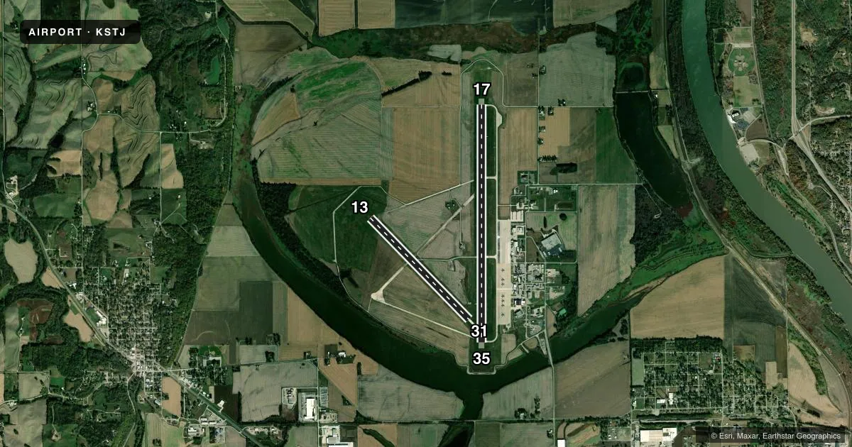
Runways & pattern
Full pagePattern entry · RWY 17
LEFT TRAFFIC| Runway | Heading (°M) | Length | Surface | Traffic |
|---|---|---|---|---|
| 17/35Favored | 176° / 356° | 8,061 ft | CONC | Standard L |
| 13/31 | 132° / 312° | 4,797 ft | CONC | Standard L |
Runway end performance
| End | TORA | TODA | ASDA | LDA | VGSI | Approach lights | Obstruction |
|---|---|---|---|---|---|---|---|
| 17 | 8,061' | 8,061' | 8,061' | 8,061' | PAPI 4-box left(3°) | — | — |
| 35 | 8,061' | 8,061' | 8,061' | 8,061' | PAPI 4-box left(2.8°) | — | — |
| 13 | 4,797' | 4,797' | 4,797' | 4,797' | PAPI 4-box left(3°) | — | — |
| 31 | 4,797' | 4,797' | 4,797' | 4,797' | PAPI 4-box left(3°) | — | — |
Declared distances in feet. TORA = takeoff run available, TODA = takeoff distance, ASDA = accelerate-stop, LDA = landing distance.
Airport sketch
Runways drawn to scale from FAA survey coordinates, rendered over satellite imagery. Not for navigation.
Approaches & charts
ILS · 1
Services on the field
Fuel grades, oxygen, maintenance, ramp storage and lighting — as declared to the FAA by the airport operator.
Fuel & services
- Fuel
- 100LLA
- Oxygen (bottled)
- HIGH/LOW
- Airframe repair
- Major
- Power plant repair
- Major
- Other services
- AFRT,AGRI,AVNCS,CHTR,INSTR,RNTL,SALES,SURV
Ramp & ground
- Transient storage
- Tie-down
- Hangar
- Landing fee
- No fee published
- Customs
- Not available
- Lighting schedule
- SEE RMK
- Beacon schedule
- SS-SR
- Beacon
- White / Green (civil land)(WG)
- Wind indicator
- Lighted
- Segmented circle
- Yes
Fuel & FBOs
Cheapest 100LL and Jet A on the field and nearby. Always confirm with the FBO before taxi.
Airport notes
Surface conditions, obstructions, local procedures, lighting outages and other notes published with each FAA cycle.
General notes
- FOR ADVY & POSITION INFO CALL STJ ATCT OR MONTR ATCT FREQ WHEN CLSD.
- ARPT CLSD TO ACFT OVR 350000 LBS EXCEPT PPR.
- ARFF AVBL BY ANG.
- HIGH MIGRATORY BIRD ACTIVITY OCT THRU MAR ON & INVOF ARPT.
- CAUTION: AFLD SUR BY LAKES AND MISSOURI RIVER. MODERATE SMALL BIRD ACT MID-NOV THRU MID-MAR AND MAY THRU AUG AND INCREASED BIRD ACTIVITY MID-MAR THRU APR AND SEP THRU MID-NOV. INTS ANG TACTICAL TRNG WITHIN ARPT TFC AREA.
- FUEL - A++ (MIL).
- AIRFIELD CONDITIONS ARE NOT MONITORED BETWEEN THE HOURS OF 1600L-0700L
- OPR 1300-2000Z++ MON-FRI, EXC HOL. PPR RQR FOR FULL STOP ONLY AND VALID +/- 30 MIN. TRAN ALERT SVC AND FAC AVBL 1330-2130Z++ MON-FRI, OT BY PPR APVL ONLY. NO TRAN ALERT MAINT AVBL, NON C130 CREW MUST BE PRESENT FOR REFUEL. LTD FUEL OPR AND EXTREMELY LTD PARK. 139 AW BASE OPS DSN 356-3596/3138/3260. IF NO ANSWER CTC COMD POST DSN 356-3224/3225, C816-236-3224/3225.
- ANG: CREWS ATNDG AATTC COURSES CTC BRADY OPS 349.15.
- ANG: CSTMS 1400-2200++ MON-FRI. AFT HRS ARR MUST BE SKED 48 HRS IN ADVN BY FONE DURG RGLR BUS HRS, CTC AFLD MGMT AT C816-236-3596. INSP NOT ALWAYS AVBL AFT HRS AND WKENDS.
- FOR CD IF UNA TO CTC ON FSS FREQ, CTC KANSAS CITY APCH AT 816-329-2710.
- ANG: MODERATE SMALL BIRD ACT POSSIBLE SR TO SS. BASH II PERIOD (1 OCT-15 APR). MIL ACFT SEE AP/1 ENTRY FOR DETAILED BASH INFO.
- TWY B BTN RWY 17/35 AND RWY 13/31 CLSD
Lighting notes
- HIRL RWY 17/35 PRESET ON LOW INTST; TO INCR INTST; ACTVT MIRL RWY 13/31 AND REIL RWYS 17/35 - CTAF.
Runway surface & condition
- 17/35PCR VALUE: 50/R/C/W/T
- 13/31RWY 13/31 NOT AVBL FOR PART 121/PART 380 OPS WITH SKED PAX CARRYING OPS MORE THAN 9 PAX SEATS AND NON-SKED PAX CARRYING OPS MORE THAN 30 PAX SEATS. RWY 13/31 HAS ASSAULT STRIP PANELS THAT ARE CERISE AND ORANGE IN COLOR.
Other notes
- CLSD TO ACR OPNS OVER 30 PSGR SEATS EXCEPT 48 HRS PPR; CALL AMGR (816) 271-4886. FOR ASSISTANCE IN ARFF INDEX C CTC AIR NATIONAL GUARD.
- 1FOR SVCS AFT HRS CALL 816-271-3450 OR 816-262-4919.
- 17/35CENTER 130 FT GROOVED.
VFR map & nearby airports
VFR sectional. Tap any ICAO chip to open that airport.
Key facts · KSTJ
Answer card- ICAO
- KSTJ
- Name
- ROSECRANS MEML
- Location
- ST JOSEPH, MISSOURI
- Elevation
- 826.5 ft MSL
- Traffic pattern altitude
- 1,826.5 ft MSL (1,000 AGL)
- Control tower
- Towered · WED-THU 0800-0000, FRI-TUE 0800-1800, OT BY NOTAM
- Total runways
- 2
- Longest runway
- 17/35 · 8,061 ft
- Published ILS approaches
- 1
- Published frequencies
- 11
- Magnetic variation
- 4°
- Current flight rules
- VFR
- Current wind
- 220° at 12 kt
- Favored runway now
- RWY 17
Rosecrans Meml Airport is in St Joseph, Missouri. Field elevation is 826.5 ft MSL. The airport has two runways. The longest is 8,061 ft. Runway 17/35 is 8,061 ft concrete. Runway 13/31 is 4,797 ft concrete.
The control tower is open Wednesday through Thursday from 0800 to 0000 local. Friday through Tuesday it is open 0800 to 1800 local. Tower service is OTS by NOTAM outside those hours. One ILS approach is published for runway 35. Pattern altitude is not published. Use the standard 1,000 ft AGL for light piston traffic unless the current Chart Supplement says otherwise.
PAN AM Flight Services is on the field. It carries 100LL and Jet A Prist. The published remarks also note limited fuel operations. They also note extremely limited parking and that airfield conditions are not monitored overnight. Expect military activity on the field. Bird activity can also be a factor, especially during the published hazard periods. Runway 13/31 has special use restrictions for some passenger operations. If you are planning anything outside a normal light-aircraft stop, check the current Chart Supplement and call the airport operator before you launch. The field is close to the Missouri River and lakes. Watch for local weather changes and bird traffic on arrival.