METAR & TAF 78Y
78Y does not publish a METAR.
Showing the nearest reporting station: KEVU (NORTHWEST MISSOURI RGNL) · 4.0 NM away. Conditions at 78Y may differ.
METAR · KEVU
Observed 17:15Z
KEVU 271715Z AUTO 22007KT 10SM CLR 33/24 A2980 RMK AO2 T03370246
- Wind
- 220° @ 7 kt
- Visibility
- 10 SM
- Temp / Dew
- 33°C / 24°C
- Altimeter
- 29.80 inHg
- Clouds
- CLR
- Density alt
- 3,529 ft
- Ceiling
- Unlimited
- Rules
- VFR
Airport info & contacts
Manager on record, flight service, ARTCC, attendance schedule and pattern altitude — published by the FAA and refreshed every 28 days.
Location
- From city
- 3 NM SE
- VFR sectional
- OMAHA
- Pattern altitude
- 800 ft AGL · 1,784 ft MSL
- ARTCC
- ZMP · MINNEAPOLIS
- NOTAM facility
- COU (NOTAM-D)
Airport manager
- Name
- KEVIN RANKIN
- Phone
- (660) 562-7450
- Address
- 27300 JET RD., MARYVILLE MO 64468
Flight service · Hours
- FSS COU
- COLUMBIA1-800-WX-BRIEF
- Attendance
- 0800-DARK
Frequencies
Tap any row to copy the frequency to your clipboard.
Runways & pattern
Full pagePattern entry · RWY 17
LEFT TRAFFICRunway end performance
| End | TORA | TODA | ASDA | LDA | VGSI | Approach lights | Obstruction |
|---|---|---|---|---|---|---|---|
| 17 | — | — | — | — | — | — | 62', pline, 203' from thr, 125' R of cntrln, slope 0 |
Declared distances in feet. TORA = takeoff run available, TODA = takeoff distance, ASDA = accelerate-stop, LDA = landing distance.
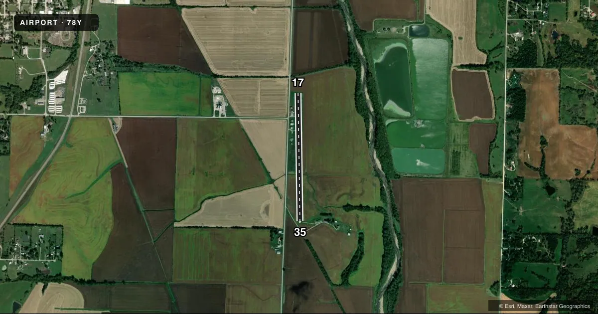
Airport sketch
Runways drawn to scale from FAA survey coordinates, rendered over satellite imagery. Not for navigation.
Approaches & charts
Services on the field
Fuel grades, oxygen, maintenance, ramp storage and lighting — as declared to the FAA by the airport operator.
Fuel & services
- Fuel
- Not available
- Airframe repair
- Major
- Power plant repair
- Major
- Other services
- INSTR,RNTL
Ramp & ground
- Transient storage
- Tie-down
- Landing fee
- No fee published
- Wind indicator
- Yes
- Segmented circle
- No
Fuel & FBOs
Cheapest 100LL and Jet A on the field and nearby. Always confirm with the FBO before taxi.
Airport notes
Surface conditions, obstructions, local procedures, lighting outages and other notes published with each FAA cycle.
General notes
- HI TENSION PWR LNS LCTD APRXLY 1200 FT NORTH OF RWY 17 THR. MKR BALLS ON TOP PWR LNS ONLY.
- FOR CD CTC MINNEAPOLIS ARTCC AT 651-463-5588.
Runway surface & condition
- 17/35RWY 35 FIRST 2500 FT CONC 14 FT WIDE; RWY 17 FIRST 550 FT GRVL/TURF 60 FT WIDE.
- 17/35RWY 17/35 WIDTH VARIANCE 14-60 FT.
Approach & departure obstructions
- 35RWY 35 CROPS 6-8 FT TALL 60 FT FM RWY THR 125 FT L-R
- 17RWY 17 DSPLCD THR MKD WITH 5 TIRES ON EACH SIDE OF RWY.
- 17APCH RATIO 15:1 TO DSPLCD THR.
Other notes
- 1AMGR LIVES ON ARPT
- 17/35CONC-TURF
VFR map & nearby airports
VFR sectional. Tap any ICAO chip to open that airport.
Key facts · 78Y
Answer card- ICAO
- 78Y
- Name
- RANKIN
- Location
- MARYVILLE, MISSOURI
- Elevation
- 984 ft MSL
- Traffic pattern altitude
- 1,784 ft MSL (800 AGL)
- Control tower
- Non-towered (use CTAF)
- Total runways
- 1
- Longest runway
- 17/35 · 3,050 ft
- Published ILS approaches
- 0
- Published frequencies
- 2
- Magnetic variation
- 5°
- Current flight rules
- VFR
- Current wind
- 220° at 7 kt
- Favored runway now
- RWY 17
RANKIN (78Y) sits near Maryville, Missouri. The field elevation is 984 ft MSL. It has one runway, 17/35, which is 3,050 ft long. There is no control tower. CTAF and UNICOM are both 122.8. No ILS approaches are published here.
Pattern altitude is 800 ft AGL, which is 1,784 ft MSL. Runway 17/35 has concrete and turf surface. The published remarks matter here. Runway 35 has crops 6 to 8 feet tall near the threshold. High tension power lines are about 1,200 ft north of the Runway 17 threshold. Marker balls are on top of the lines. Runway 17 has a displaced threshold marked with tires. The runway width also varies, so plan your rollout and takeoff with that in mind.
There are no on-field FBOs listed. Contact the airport operator directly or call the field on CTAF or UNICOM for current fuel and service availability. For clearance delivery, contact Minneapolis ARTCC at 651-463-5588. A first-time pilot should pay close attention to the displaced threshold on 17. Also watch the crop and obstacle environment on 35. This is an uncontrolled field with no published ILS.