METAR & TAF K19
K19 does not publish a METAR.
Showing the nearest reporting station: KEVU (NORTHWEST MISSOURI RGNL) · 27.0 NM away. Conditions at K19 may differ.
METAR · KEVU
Observed 19:15Z
KEVU 271915Z AUTO 23009KT 10SM CLR 35/26 A2978 RMK AO2 T03520259
- Wind
- 230° @ 9 kt
- Visibility
- 10 SM
- Temp / Dew
- 35°C / 26°C
- Altimeter
- 29.78 inHg
- Clouds
- CLR
- Density alt
- 3,679 ft
- Ceiling
- Unlimited
- Rules
- VFR
Airport info & contacts
Manager on record, flight service, ARTCC, attendance schedule and pattern altitude — published by the FAA and refreshed every 28 days.
Location
- From city
- 1 NM N
- VFR sectional
- OMAHA
- ARTCC
- ZKC · KANSAS CITY
- NOTAM facility
- COU (NOTAM-D)
Airport manager
- Name
- DEREK BROWN
- Phone
- 660-726-3935
- Address
- 106 E. CLAY, ALBANY MO 64402
Flight service · Hours
- FSS COU
- COLUMBIA1-800-WX-BRIEF
- Attendance
- Unattended
Frequencies
Tap any row to copy the frequency to your clipboard.
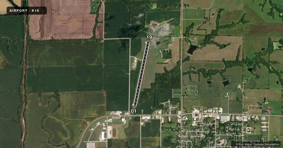
Runways & pattern
Full pagePattern entry · RWY 19
RIGHT TRAFFICRunway end performance
| End | TORA | TODA | ASDA | LDA | VGSI | Approach lights | Obstruction |
|---|---|---|---|---|---|---|---|
| 01 | — | — | — | — | PAPI 2-box left(3°) | — | 44', trees, 820' from thr, 200' R of cntrln, slope 14 |
| 19 | — | — | — | — | PAPI 2-box left(3°) | — | 5', fence, 245' from thr, 125' R of cntrln, slope 9 |
Declared distances in feet. TORA = takeoff run available, TODA = takeoff distance, ASDA = accelerate-stop, LDA = landing distance.
Airport sketch
Runways drawn to scale from FAA survey coordinates, rendered over satellite imagery. Not for navigation.
Approaches & charts
Services on the field
Fuel grades, oxygen, maintenance, ramp storage and lighting — as declared to the FAA by the airport operator.
Fuel & services
- Fuel
- 100LL
Ramp & ground
- Transient storage
- Not published
- Landing fee
- No fee published
- Wind indicator
- Lighted
- Segmented circle
- Yes
Fuel & FBOs
Cheapest 100LL and Jet A on the field and nearby. Always confirm with the FBO before taxi.
Airport notes
Surface conditions, obstructions, local procedures, lighting outages and other notes published with each FAA cycle.
General notes
- WILDLIFE ON & INVOF ARPT.
- FOR CD CTC KANSAS CITY ARTCC AT 913-254-8508.
Fuel notes
- 100LLSELF SERVICE FUEL - 24 HRS.
Runway surface & condition
- 01/19RWY 01/19 VARIOUS THLD AND EDGE LGTS ARE BROKEN OR MISSING.
Approach & departure obstructions
- 01+3-15 FT BRUSH, POST, SMALL TREES, FARM ROAD, 95-200 FT FM RWY END, 80-125 FT R.
Other notes
- MANAGERGROUNDS KEEPER.
VFR map & nearby airports
VFR sectional. Tap any ICAO chip to open that airport.
Key facts · K19
Answer card- ICAO
- K19
- Name
- ALBANY MUNI
- Location
- ALBANY, MISSOURI
- Elevation
- 891.3 ft MSL
- Traffic pattern altitude
- 1,891.3 ft MSL (1,000 AGL)
- Control tower
- Non-towered (use CTAF)
- Total runways
- 1
- Longest runway
- 01/19 · 3,300 ft
- Published ILS approaches
- 0
- Published frequencies
- 1
- Magnetic variation
- 5°
- Current flight rules
- VFR
- Current wind
- 230° at 9 kt
- Favored runway now
- RWY 19
Albany Muni is in Albany, Missouri. The field elevation is 891.3 ft MSL. It has one runway. Runway 01/19 is 3,300 ft long and concrete. The airport is not towered. CTAF is 122.9. No ILS approaches are published here.
Pattern altitude is not published. Use 1,000 ft AGL for light piston operations unless local guidance says otherwise. With the field elevation at 891.3 ft MSL, that puts the standard pattern at about 1,891.3 ft MSL. Check the current Chart Supplement before you go if you need a confirmed pattern or any local procedures.
Albany Municipal Airport is the on-field FBO. It carries AVGAS 100LL. Self-serve fuel is available 24 hours. The published remarks also note wildlife on and near the airport. Runway 01/19 has broken or missing threshold and edge lights. That matters for night work. There is also brush, posts, small trees and a farm road near the departure end of Runway 01. Clearance delivery is handled through Kansas City ARTCC at 913-254-8508.
For a first-time arrival, the main things are the single runway layout, the non-towered pattern and the lighting condition on 01/19. Keep an eye out for wildlife. Use the current Chart Supplement and a radio call on CTAF for the latest field status before arrival.