METAR & TAF 75K
75K does not publish a METAR.
Showing the nearest reporting station: KLWD (LAMONI MUNI) · 21.9 NM away. Conditions at 75K may differ.
METAR · KLWD
Observed 16:53Z
KLWD 271653Z AUTO 22009KT 10SM CLR 33/23 A2980 RMK AO2 SLP080 T03280228
- Wind
- 220° @ 9 kt
- Visibility
- 10 SM
- Temp / Dew
- 33°C / 23°C
- Altimeter
- 29.80 inHg
- Clouds
- CLR
- Density alt
- 3,592 ft
- Ceiling
- Unlimited
- Rules
- VFR
Airport info & contacts
Manager on record, flight service, ARTCC, attendance schedule and pattern altitude — published by the FAA and refreshed every 28 days.
Location
- From city
- 2 NM NE
- VFR sectional
- OMAHA
- ARTCC
- ZKC · KANSAS CITY
- NOTAM facility
- COU (NOTAM-D)
Airport manager
- Name
- CITY ADMINISTRATOR
- Phone
- 660-425-3511
- Address
- PO BOX 344, BETHANY MO 64424
Flight service · Hours
- FSS COU
- COLUMBIA1-800-WX-BRIEF
- Attendance
- Unattended
Frequencies
Tap any row to copy the frequency to your clipboard.
Runways & pattern
Full pagePattern entry · RWY 21
LEFT TRAFFICRunway end performance
| End | TORA | TODA | ASDA | LDA | VGSI | Approach lights | Obstruction |
|---|---|---|---|---|---|---|---|
| 03 | — | — | — | — | — | — | 20', trees, 290' from thr, 85' R of cntrln, slope 4 |
| 21 | — | — | — | — | — | — | 22', bldg, 270' from thr, 115' R of cntrln, slope 3 |
Declared distances in feet. TORA = takeoff run available, TODA = takeoff distance, ASDA = accelerate-stop, LDA = landing distance.
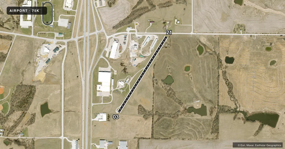
Airport sketch
Runways drawn to scale from FAA survey coordinates, rendered over satellite imagery. Not for navigation.
Approaches & charts
Services on the field
Fuel grades, oxygen, maintenance, ramp storage and lighting — as declared to the FAA by the airport operator.
Fuel & services
- Fuel
- Not available
- Oxygen (bottled)
- Not available
- Oxygen (bulk)
- Not available
Ramp & ground
- Transient storage
- Tie-down
- Landing fee
- No fee published
- Lighting schedule
- SEE RMK
- Wind indicator
- Yes
- Segmented circle
- Yes
Fuel & FBOs
Cheapest 100LL and Jet A on the field and nearby. Always confirm with the FBO before taxi.
Airport notes
Surface conditions, obstructions, local procedures, lighting outages and other notes published with each FAA cycle.
General notes
- NSTD RY SAFETY AREAS BYD EACH RY END; RY 03 INCORRECT TERRAIN GRADIENTS; RY 21 LARGE DROP OFF, BRUSH, SMALL TREES, FENCE AND ROAD.
- FOR CD CTC KANSAS CITY ARTCC AT 913-254-8508.
Lighting notes
- LIRL RY 03/21 THREE CLICKS TO ACTVT CTAF.
Runway surface & condition
- 03/21LIRL NSTD DUE TO INCORRECT SPACING AND NON-FRANGIBLE MOUNTS.
Approach & departure obstructions
- 03RY 03 +1'-3' GND 0'-200' FM RY END, L & R.
- 21+1-51 FT BRUSH; TREES; FENCES; ROADS; UTILITY LINES &POLES 0-200 FT FM RY END L/R.
- 03RWY 03 MARKINGS FADED
- 21RWY 21 MARKINGS FADED
- 03RY 03 NSTD BSC MARKINGS; RY CNTRLN INCORRECT SPACING OF STRIPES & GAPS AT DESIGNATION MARKING.
- 21RY 21 NSTD BSC MARKINGS; RY CNTRLN INCORRECT SPACING OF STRIPES & GAPS AT DESIGNATION MARKING & INCORRECT LATERAL SPACING OF DESIGNATION NMBRS.
- 21RY 21 APCH SLOPE 0:1 TO DSPLCD THLD. +1-51 FT TREES; BRUSH; FENCES; UTILITY LINES; POLES; HIGH GND & CONSTRUCTION EQUIP; 0-300 FT FM DSPLCD THLD L/R OF CNTRLN; 9:1 BASED ON DSPLCD THLD.
Other notes
- 03/21RY HAS MULTIPLE OPEN CRACKS, PAVEMENT RAVELING AND PRODUCING FOD.
VFR map & nearby airports
VFR sectional. Tap any ICAO chip to open that airport.
Key facts · 75K
Answer card- ICAO
- 75K
- Name
- BETHANY MEML
- Location
- BETHANY, MISSOURI
- Elevation
- 1,035 ft MSL
- Traffic pattern altitude
- 2,035 ft MSL (1,000 AGL)
- Control tower
- Non-towered (use CTAF)
- Total runways
- 1
- Longest runway
- 03/21 · 2,255 ft
- Published ILS approaches
- 0
- Published frequencies
- 1
- Magnetic variation
- 4°
- Current flight rules
- VFR
- Current wind
- 220° at 9 kt
- Favored runway now
- RWY 21
Bethany Memorial Airport sits in Bethany, Missouri. The field elevation is 1,035 ft MSL. It has one runway. Runway 03/21 is 2,255 ft long and asphalt. There is no control tower. CTAF is 122.9. No ILS approaches are published here.
Pattern altitude is not published, so use 1,000 ft AGL for light piston traffic unless the current Chart Supplement says otherwise. That puts the standard pattern at 2,035 ft MSL based on the field elevation. The runway lighting is low intensity and needs three clicks on CTAF. Published remarks also note non-standard runway safety areas beyond both ends. They also note surface issues on 03/21 that include cracks, raveling and foreign object debris. Runway 03 has nearby ground obstructions close to the end. Runway 21 has a drop-off, brush, trees, fences, utility lines, poles, high ground and construction equipment near the displaced threshold and beyond the end.
There are no on-field FBOs listed. Check current services before you go. For clearance delivery, contact Kansas City ARTCC at 913-254-8508. Use extra caution on arrival and departure. This is a small non-towered field with runway condition and obstruction issues that matter on a short strip.