METAR & TAF KCHT
KCHT does not publish a METAR.
Showing the nearest reporting station: KEZZ (CAMERON MEML) · 36.2 NM away. Conditions at KCHT may differ.
METAR · KEZZ
Observed 18:55Z
KEZZ 271855Z AUTO 22010KT 10SM CLR 35/24 A2983 RMK AO2
- Wind
- 220° @ 10 kt
- Visibility
- 10 SM
- Temp / Dew
- 35°C / 24°C
- Altimeter
- 29.83 inHg
- Clouds
- CLR
- Density alt
- 3,483 ft
- Ceiling
- Unlimited
- Rules
- VFR
Airport info & contacts
Manager on record, flight service, ARTCC, attendance schedule and pattern altitude — published by the FAA and refreshed every 28 days.
Location
- From city
- 3 NM E
- VFR sectional
- KANSAS CITY
- ARTCC
- ZKC · KANSAS CITY
- NOTAM facility
- COU (NOTAM-D)
Airport manager
- Name
- TOBY CALIVERE
- Phone
- 660-646-5270
- Address
- 13844 LIV 253, CHILLICOTHE MO 64601
Flight service · Hours
- FSS COU
- COLUMBIA1-800-WX-BRIEF
- Attendance
- MON-FRI · 0800-1700
- SAT · 0800-1200
Frequencies
Tap any row to copy the frequency to your clipboard.
Runways & pattern
Full pagePattern entry · RWY 20
LEFT TRAFFIC| Runway | Heading (°M) | Length | Surface | Traffic |
|---|---|---|---|---|
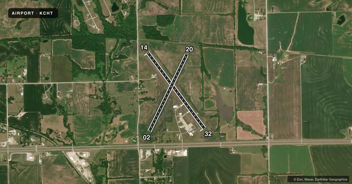
| 14/32 | 140° / 320° | 3,899 ft | CONC | Standard L |
| 02/20Favored | 23° / 203° | 3,503 ft | TURF | Standard L |
Runway end performance
| End | TORA | TODA | ASDA | LDA | VGSI | Approach lights | Obstruction |
|---|---|---|---|---|---|---|---|
| 14 | — | — | — | — | PAPI 4-box left(3°) | — | — |
| 32 | — | — | — | — | PAPI 4-box right(3.5°) | — | — |
| 20 | — | — | — | — | — | — | 39', tree, 544' from thr, 130' R of cntrln, slope 13 |
Declared distances in feet. TORA = takeoff run available, TODA = takeoff distance, ASDA = accelerate-stop, LDA = landing distance.
Airport sketch
Runways drawn to scale from FAA survey coordinates, rendered over satellite imagery. Not for navigation.
Approaches & charts
Services on the field
Fuel grades, oxygen, maintenance, ramp storage and lighting — as declared to the FAA by the airport operator.
Fuel & services
- Fuel
- 100LL
- Oxygen (bottled)
- Not available
- Oxygen (bulk)
- Not available
- Other services
- INSTR
Ramp & ground
- Transient storage
- Tie-down
- Hangar
- Landing fee
- No fee published
- Customs
- Not available
- Lighting schedule
- SEE RMK
- Beacon schedule
- SS-SR
- Beacon
- White / Green (civil land)(WG)
- Wind indicator
- Yes
- Segmented circle
- Yes
Fuel & FBOs
Cheapest 100LL and Jet A on the field and nearby. Always confirm with the FBO before taxi.
Airport notes
Surface conditions, obstructions, local procedures, lighting outages and other notes published with each FAA cycle.
General notes
- WILDLIFE, MIGRATORY BIRDS & GEESE ON & INVOF ARPT.
- NTSD RWY SAFETY AREA BYND BOTH ENDS OF RWY 02/20; INCORRECT TERRAIN GRADES AND CROPS.
- PAEW INVOF ARPT.
- FOR CD IF UNA TO CTC ON FSS FREQ, CTC KANSAS CITY ARTCC AT 913-254-8508.
Lighting notes
- ACTVT REIL RWYS 14 & 32; PAPI RWYS 14 & 32; MIRL RWY 14 & 32 - CTAF.
Approach & departure obstructions
- 02RWY 02/20 MARKED WITH LARGE YELLOW CONES. DSPLCD THRS MARKED WITH 3 LARGE YELLOW CONES ON EACH SIDE OF RWY.
- 02RWY 20 - 23:1 BASED ON DSPLCD THR
VFR map & nearby airports
VFR sectional. Tap any ICAO chip to open that airport.
Key facts · KCHT
Answer card- ICAO
- KCHT
- Name
- CHILLICOTHE MUNI
- Location
- CHILLICOTHE, MISSOURI
- Elevation
- 783.3 ft MSL
- Traffic pattern altitude
- 1,783.3 ft MSL (1,000 AGL)
- Control tower
- Non-towered (use CTAF)
- Total runways
- 2
- Longest runway
- 14/32 · 3,899 ft
- Published ILS approaches
- 0
- Published frequencies
- 2
- Magnetic variation
- 3°
- Current flight rules
- VFR
- Current wind
- 220° at 10 kt
- Favored runway now
- RWY 20
Chillicothe Muni sits in Chillicothe, Missouri. Field elevation is 783.3 ft MSL. The airport has two runways. The longest is runway 14/32 at 3,899 ft. Runway 02/20 is turf at 3,503 ft. This is an unattended field with no control tower. CTAF and UNICOM are both 122.8.
No ILS approaches are published here. Pattern altitude is not published, so a light piston pilot should plan on the standard 1,000 ft AGL unless the current Chart Supplement says otherwise. The on-field FBO is Chillicothe Municipal Airport. It carries AVGAS 100LL. Call (660) 646-5270 for current service details before you go.
There are a few operational items worth planning for. Runway 14 and 32 have lighting, PAPI and runway end identifier lights. The lights are controlled by CTAF. Runway 02/20 has a displaced threshold marked with large yellow cones. The field also has nonstandard runway safety areas beyond both ends of 02/20. Wildlife is reported on and near the airport. Parachute jumping is also in the vicinity. If you need clearance delivery and cannot reach Flight Service, Kansas City ARTCC is listed in the remarks. For any current noise or field-use restrictions, check the current FAA Chart Supplement before departure.