METAR & TAF MO8
MO8 does not publish a METAR.
Showing the nearest reporting station: KIRK (KIRKSVILLE RGNL) · 28.9 NM away. Conditions at MO8 may differ.
METAR · KIRK
Observed 15:55Z
KIRK 271555Z AUTO 20008KT 10SM SCT100 29/24 A2984 RMK AO2 SLP097 T02890239 TSNO $
- Wind
- 200° @ 8 kt
- Visibility
- 10 SM
- Temp / Dew
- 29°C / 24°C
- Altimeter
- 29.84 inHg
- Clouds
- SCT
- Density alt
- 2,826 ft
- Ceiling
- Unlimited
- Rules
- VFR
Airport info & contacts
Manager on record, flight service, ARTCC, attendance schedule and pattern altitude — published by the FAA and refreshed every 28 days.
Location
- From city
- 2 NM E
- VFR sectional
- KANSAS CITY
- ARTCC
- ZKC · KANSAS CITY
- NOTAM facility
- COU (NOTAM-D)
Airport manager
- Name
- RANDY STOCKWELL
- Phone
- 660-258-7317
- Address
- 28540 JET WAY DRIVE, PO BOX 283, BROOKFIELD MO 64628
Flight service · Hours
- FSS COU
- COLUMBIA1-800-WX-BRIEF
- Attendance
- IREG
Frequencies
Tap any row to copy the frequency to your clipboard.
Runways & pattern
Full pagePattern entry · RWY 18
LEFT TRAFFICRunway end performance
| End | TORA | TODA | ASDA | LDA | VGSI | Approach lights | Obstruction |
|---|---|---|---|---|---|---|---|
| 18 | — | — | — | — | PAPI 4-box left(3°) | — | — |
| 36 | — | — | — | — | PAPI 4-box left(3°) | — | — |
Declared distances in feet. TORA = takeoff run available, TODA = takeoff distance, ASDA = accelerate-stop, LDA = landing distance.
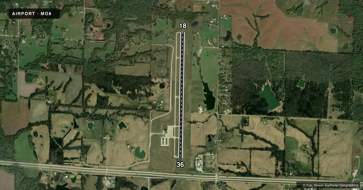
Airport sketch
Runways drawn to scale from FAA survey coordinates, rendered over satellite imagery. Not for navigation.
Approaches & charts
Services on the field
Fuel grades, oxygen, maintenance, ramp storage and lighting — as declared to the FAA by the airport operator.
Fuel & services
- Fuel
- 100LLA
Ramp & ground
- Transient storage
- Tie-down
- Lighting schedule
- SEE RMK
- Beacon schedule
- SS-SR
- Beacon
- White / Green (civil land)(WG)
- Wind indicator
- Lighted
- Segmented circle
- Yes
Fuel & FBOs
Cheapest 100LL and Jet A on the field and nearby. Always confirm with the FBO before taxi.
Airport notes
Surface conditions, obstructions, local procedures, lighting outages and other notes published with each FAA cycle.
General notes
- FOR SERVICE AFTER HRS, CALL PHONE NUMBERS POSTED ON AIRPORT MGMT OFFICE DOOR.
- NUMEROUS WATERFOWL & DEER ON & INVOF ARPT.
- FOR CD CTC KANSAS CITY ARTCC AT 913-254-8508.
Lighting notes
- ACTVT MIRL RY 18/36; PAPI RYS 18 & 36; REIL RYS 18 & 36 - CTAF.
Fuel notes
- 100LLSELF-SERVICE FUEL AVAILABLE 24 HRS.
VFR map & nearby airports
VFR sectional. Tap any ICAO chip to open that airport.
Key facts · MO8
Answer card- ICAO
- MO8
- Name
- NORTH CENTRAL MISSOURI RGNL
- Location
- BROOKFIELD, MISSOURI
- Elevation
- 844.5 ft MSL
- Traffic pattern altitude
- 1,844.5 ft MSL (1,000 AGL)
- Control tower
- Non-towered (use CTAF)
- Total runways
- 1
- Longest runway
- 18/36 · 5,002 ft
- Published ILS approaches
- 0
- Published frequencies
- 1
- Magnetic variation
- 0°
- Current flight rules
- VFR
- Current wind
- 200° at 8 kt
- Favored runway now
- RWY 18
North Central Missouri Regional Airport sits in Brookfield, Missouri. The field elevation is 844.5 ft MSL. It has one runway. Runway 18/36 is 5,002 ft long with concrete pavement. There is no control tower. CTAF is 122.9. No ILS approaches are published here.
The pattern altitude is not published in the facts. Use the standard 1,000 ft AGL for light piston traffic unless the current FAA Chart Supplement says otherwise. The airport has medium intensity runway lights on 18/36. PAPI is installed on both ends. REIL is also installed on both ends. The runway end lights work on the common traffic advisory frequency.
North Central Missouri Regional Airport is the on-field FBO. It carries 100LL and Jet A. Self-serve fuel is available 24 hours. For after-hours service, call the numbers posted on the airport management office door. Watch for waterfowl and deer near the airport. If you need clearance delivery, contact Kansas City Center. For any current noise, lighting, or operational changes, check the current FAA Chart Supplement before departure.