METAR & TAF K89
K89 does not publish a METAR.
Showing the nearest reporting station: KMBY (OMAR N BRADLEY) · 16.1 NM away. Conditions at K89 may differ.
METAR · KMBY
Observed 04:35Z
KMBY 270435Z AUTO 17003KT 10SM CLR 27/25 A2990 RMK AO2
- Wind
- 170° @ 3 kt
- Visibility
- 10 SM
- Temp / Dew
- 27°C / 25°C
- Altimeter
- 29.90 inHg
- Clouds
- CLR
- Density alt
- 2,554 ft
- Ceiling
- Unlimited
- Rules
- VFR
Airport info & contacts
Manager on record, flight service, ARTCC, attendance schedule and pattern altitude — published by the FAA and refreshed every 28 days.
Location
- From city
- 1 NM SE
- VFR sectional
- KANSAS CITY
- ARTCC
- ZKC · KANSAS CITY
- NOTAM facility
- COU (NOTAM-D)
Airport manager
- Name
- DAVE COLEMAN
- Phone
- 660-385-6208
- Address
- 1001 PATTON ST, MACON MO 63552
Flight service · Hours
- FSS COU
- COLUMBIA1-800-WX-BRIEF
- Attendance
- 0800-1700
Frequencies
Tap any row to copy the frequency to your clipboard.
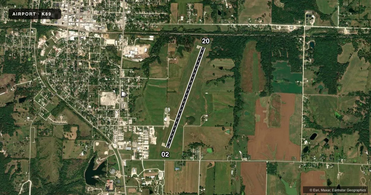
Runways & pattern
Full pagePattern entry · RWY 20
LEFT TRAFFICRunway end performance
| End | TORA | TODA | ASDA | LDA | VGSI | Approach lights | Obstruction |
|---|---|---|---|---|---|---|---|
| 02 | — | — | — | — | PAPI 4-box left(3°) | — | 11', road, 400' from thr, 250' R of cntrln, slope 18 |
| 20 | — | — | — | — | PAPI 4-box left(3°) | — | — |
Declared distances in feet. TORA = takeoff run available, TODA = takeoff distance, ASDA = accelerate-stop, LDA = landing distance.
Airport sketch
Runways drawn to scale from FAA survey coordinates, rendered over satellite imagery. Not for navigation.
Approaches & charts
Services on the field
Fuel grades, oxygen, maintenance, ramp storage and lighting — as declared to the FAA by the airport operator.
Fuel & services
- Fuel
- 100LLA+
- Oxygen (bottled)
- Not available
- Oxygen (bulk)
- Not available
- Airframe repair
- Major
- Power plant repair
- Major
- Other services
- INSTR
Ramp & ground
- Transient storage
- Tie-down
- Hangar
- Landing fee
- No fee published
- Customs
- Not available
- Lighting schedule
- SEE RMK
- Beacon schedule
- SS-SR
- Beacon
- White / Green (civil land)(WG)
- Wind indicator
- Lighted
- Segmented circle
- Yes
Fuel & FBOs
Cheapest 100LL and Jet A on the field and nearby. Always confirm with the FBO before taxi.
Airport notes
Surface conditions, obstructions, local procedures, lighting outages and other notes published with each FAA cycle.
General notes
- CROP DUSTING ACFT ON & INVOF ARPT APR-OCT.
- DEER ON RWY AT EARLY & LATE HRS.
- FOR SVC AFT HRS CALL 660-385-6208.
- FOR CD CTC KANSAS CITY ARTCC AT 913-254-8508.
Lighting notes
- ACTVT REIL RWY 02 & 20; PAPI RWY 02 & 20; MIRL RWY 02/20 - CTAF.
- ULTRALIGHT ACFT ON & INVOF ARPT.
Fuel notes
- 100LLSELF SVC 100LL AND JET-A FUEL AVBL 24 HRS.
Approach & departure obstructions
- 20UNUSBL BYD 5 DEGS LEFT OF CNTRLN.
- 02RWY 2 20:1 BASED ON DSPLCD THR.
VFR map & nearby airports
VFR sectional. Tap any ICAO chip to open that airport.
Key facts · K89
Answer card- ICAO
- K89
- Name
- MACON-FOWER MEML
- Location
- MACON, MISSOURI
- Elevation
- 878 ft MSL
- Traffic pattern altitude
- 1,878 ft MSL (1,000 AGL)
- Control tower
- Non-towered (use CTAF)
- Total runways
- 1
- Longest runway
- 02/20 · 4,150 ft
- Published ILS approaches
- 0
- Published frequencies
- 2
- Magnetic variation
- 2°
- Current flight rules
- VFR
- Current wind
- 170° at 3 kt
- Favored runway now
- RWY 20
Macon-Fower Memorial Airport is in Macon, Missouri. Field elevation is 878 ft MSL. The airport has one runway, 02/20, which is 4,150 ft long and paved with concrete. There is no control tower. CTAF and UNICOM are both 122.8. No ILS approaches are published here.
Pattern altitude is not published. Use the standard 1,000 ft AGL for light piston traffic unless the current Chart Supplement says otherwise. The published remarks matter here. Runway 2 has a displaced-threshold obstacle note. Runway 20 is unusable beyond 5 degrees left of centerline. Runway edge lights, runway end identifier lights and PAPI are installed on both ends. Self-serve 100LL and Jet-A are available 24 hours.
The on-field FBO is Macon-Fower Memorial Airport. It carries AVGAS 100LL and Jet-A. For after-hours service, call the airport at (660) 385-6208. Watch for deer near dawn and dusk. Ultralight traffic also operates in the area. Crop dusting aircraft operate from April through October. If you need IFR clearance, contact Kansas City Center at 913-254-8508 before departure.