METAR & TAF KMBY
Current METAR
Observed 13:35Z
KMBY 271335Z AUTO 22009KT 10SM CLR 28/23 A2989 RMK AO2
- Wind
- 220° @ 9 kt
- Visibility
- 10 SM
- Temp / Dew
- 28°C / 23°C
- Altimeter
- 29.89 inHg
- Clouds
- CLR
- Density alt
- 2,672 ft
- Ceiling
- Unlimited
- Rules
- VFR
Airport info & contacts
Manager on record, flight service, ARTCC, attendance schedule and pattern altitude — published by the FAA and refreshed every 28 days.
Location
- From city
- 3 NM N
- VFR sectional
- KANSAS CITY
- ARTCC
- ZKC · KANSAS CITY
- NOTAM facility
- COU (NOTAM-D)
Airport manager
- Name
- TOM SANDERS
- Phone
- 660-269-8705
- Address
- CITY HALL 101 W. REED, MOBERLY MO 65270
Flight service · Hours
- FSS COU
- COLUMBIA1-800-WX-BRIEF
- Attendance
- 0800-1700
Frequencies
Tap any row to copy the frequency to your clipboard.
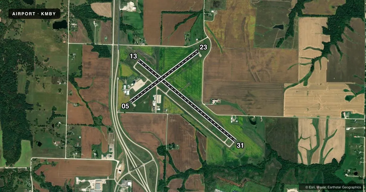
Runways & pattern
Full pagePattern entry · RWY 23
LEFT TRAFFIC| Runway | Heading (°M) | Length | Surface | Traffic |
|---|---|---|---|---|
| 13/31 | 129° / 309° | 5,000 ft | CONC | Standard L |
| 05/23Favored | 52° / 232° | 3,350 ft | CONC | Standard L |
Runway end performance
| End | TORA | TODA | ASDA | LDA | VGSI | Approach lights | Obstruction |
|---|---|---|---|---|---|---|---|
| 13 | — | — | — | — | PAPI 4-box left(3°) | — | — |
| 31 | — | — | — | — | PAPI 4-box left(3°) | — | — |
Declared distances in feet. TORA = takeoff run available, TODA = takeoff distance, ASDA = accelerate-stop, LDA = landing distance.
Airport sketch
Runways drawn to scale from FAA survey coordinates, rendered over satellite imagery. Not for navigation.
Approaches & charts
Services on the field
Fuel grades, oxygen, maintenance, ramp storage and lighting — as declared to the FAA by the airport operator.
Fuel & services
- Fuel
- 100LLA+
- Oxygen (bottled)
- Not available
- Oxygen (bulk)
- Not available
- Airframe repair
- Major
- Power plant repair
- Major
- Other services
- INSTR
Ramp & ground
- Transient storage
- Tie-down
- Hangar
- Landing fee
- No fee published
- Customs
- Not available
- Lighting schedule
- SEE RMK
- Beacon schedule
- SS-SR
- Beacon
- White / Green (civil land)(WG)
- Wind indicator
- Lighted
- Segmented circle
- Yes
Fuel & FBOs
Cheapest 100LL and Jet A on the field and nearby. Always confirm with the FBO before taxi.
Airport notes
Surface conditions, obstructions, local procedures, lighting outages and other notes published with each FAA cycle.
General notes
- SPRAYER & ULTRALIGHT ACFT ON & INVOF ARPT.
- FOR CD CTC KANSAS CITY ARTCC AT 913-254-8508.
- AFT HRS CTC 660-998-0134
Lighting notes
- MIRL RWYS 05/23 AND 13/31 PRESET ON LOW INTST; TO INCR INTST AND ACTVT REIL RWYS 13 & 31 - CTAF.
Fuel notes
- 100LLSELF SVC 100LL AND JET A FUEL AVBL 24 HRS.
VFR map & nearby airports
VFR sectional. Tap any ICAO chip to open that airport.
Key facts · KMBY
Answer card- ICAO
- KMBY
- Name
- OMAR N BRADLEY
- Location
- MOBERLY, MISSOURI
- Elevation
- 866.8 ft MSL
- Traffic pattern altitude
- 1,866.8 ft MSL (1,000 AGL)
- Control tower
- Non-towered (use CTAF)
- Total runways
- 2
- Longest runway
- 13/31 · 5,000 ft
- Published ILS approaches
- 0
- Published frequencies
- 2
- Magnetic variation
- 1°
- Current flight rules
- VFR
- Current wind
- 220° at 9 kt
- Favored runway now
- RWY 23
Omar N Bradley Airport is in Moberly, Missouri. The field elevation is 866.8 ft MSL. It has two concrete runways. The longest is 5,000 ft on runway 13/31. There is no control tower. CTAF and UNICOM are both 122.7. No ILS approaches are published, so plan with the current chart and your own approach setup.
The published pattern altitude is not listed. Use 1,000 ft AGL for light piston operations unless the current Chart Supplement says otherwise. The airport has one on-field FBO, Omar N. Bradley Airport. It carries 100LL and Jet A. Self-service 100LL and Jet A are available 24 hours. After hours contact is 660-998-0134. For clearance delivery, contact Kansas City ARTCC at 913-254-8508.
A few operational notes matter here. Sprayer and ultralight aircraft operate on and near the airport. The runway lights on 05/23 and 13/31 are preset on low intensity. Use the CTAF to increase intensity and to activate the runway end identifier lights on 13 and 31. Check the current Chart Supplement for any published noise or curfew restrictions before flying into the field. This is a non-towered airport. Expect self-announce traffic and stay sharp on the radio.