METAR & TAF KCOU
Current METAR
Observed 00:54Z
KCOU 270054Z 22003KT 10SM CLR 32/26 A2989 RMK AO2 SLP110 T03220256 $
- Wind
- 220° @ 3 kt
- Visibility
- 10 SM
- Temp / Dew
- 32°C / 26°C
- Altimeter
- 29.89 inHg
- Clouds
- CLR
- Density alt
- 3,180 ft
- Ceiling
- Unlimited
- Rules
- VFR
Airport info & contacts
Manager on record, flight service, ARTCC, attendance schedule and pattern altitude — published by the FAA and refreshed every 28 days.
Location
- From city
- 10 NM SE
- VFR sectional
- KANSAS CITY
- ARTCC
- ZKC · KANSAS CITY
- NOTAM facility
- COU (NOTAM-D)
Airport manager
- Name
- MICHAEL PARKS
- Phone
- 573-817-5063
- Address
- 11300 S. AIRPORT RD, COLUMBIA MO 65201
Flight service · Hours
- FSS COU
- COLUMBIA1-800-WX-BRIEF
- Attendance
- ALL
Frequencies
Tap any row to copy the frequency to your clipboard.
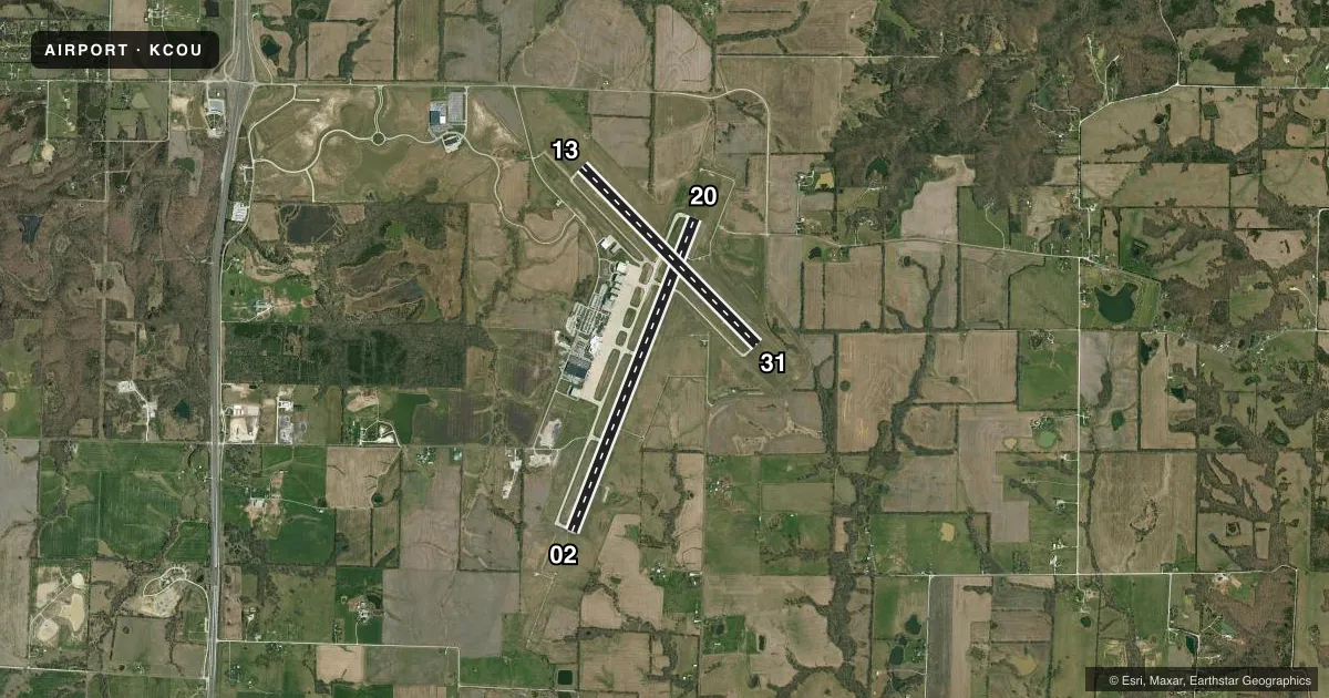
Runways & pattern
Full pagePattern entry · RWY 20
LEFT TRAFFIC| Runway | Heading (°M) | Length | Surface | Traffic |
|---|---|---|---|---|
| 02/20Favored | 21° / 201° | 7,401 ft | CONC | Standard L |
| 13/31 | 135° / 315° | 5,500 ft | CONC | Standard L |
Runway end performance
| End | TORA | TODA | ASDA | LDA | VGSI | Approach lights | Obstruction |
|---|---|---|---|---|---|---|---|
| 02 | 7,401' | 7,401' | 7,401' | 7,401' | — | MALSR | — |
| 20 | 7,401' | 7,401' | 7,401' | 7,401' | PAPI 4-box left(3°) | — | — |
| 13 | 5,500' | 5,500' | 5,500' | 5,500' | PAPI 4-box left(3°) | — | — |
| 31 | 5,500' | 5,500' | 5,500' | 5,500' | PAPI 4-box left(3°) | — | — |
Declared distances in feet. TORA = takeoff run available, TODA = takeoff distance, ASDA = accelerate-stop, LDA = landing distance.
Airport sketch
Runways drawn to scale from FAA survey coordinates, rendered over satellite imagery. Not for navigation.
Approaches & charts
ILS · 1
Services on the field
Fuel grades, oxygen, maintenance, ramp storage and lighting — as declared to the FAA by the airport operator.
Fuel & services
- Fuel
- 100LLA
- Oxygen (bottled)
- Not available
- Oxygen (bulk)
- Low pressure
- Airframe repair
- Major
- Power plant repair
- Major
- Other services
- AFRT,AVNCS,CHTR,INSTR,RNTL,SALES
Ramp & ground
- Transient storage
- Tie-down
- Hangar
- Landing fee
- No fee published
- Customs
- Not available
- Lighting schedule
- SEE RMK
- Beacon schedule
- SS-SR
- Beacon
- White / Green (civil land)(WG)
- Wind indicator
- Lighted
- Segmented circle
- Yes
Fuel & FBOs
Cheapest 100LL and Jet A on the field and nearby. Always confirm with the FBO before taxi.
Airport notes
Surface conditions, obstructions, local procedures, lighting outages and other notes published with each FAA cycle.
General notes
- FOR CD CTC MIZZOU APCH AT 417-868-5620/5619.
Lighting notes
- WHEN ATCT CLSD ACTVT MALSR RWY 02; REIL RWY 20; HIRL RWY 02/20; MIRL RWY 13/31 - CTAF. PAPI RWY 13 & 31, 20 OPR CONSLY.
Runway surface & condition
- 02/20PCR VALUE: 403/R/D/W/T
- 13/31PCR VALUE: 386/R/B/W/T
Other notes
- 48 HRS PPR FOR UNSKED ACR OPNS WITH MORE THAN 30 PSGR SEATS; CALL SAFETY OFFICE (573) 817-5063 OR (573) 817-5062 ARFF INDEX C AVBL UPON REQUEST.
- MANAGERAIRPORT MANAGER
VFR map & nearby airports
VFR sectional. Tap any ICAO chip to open that airport.
Key facts · KCOU
Answer card- ICAO
- KCOU
- Name
- COLUMBIA RGNL
- Location
- COLUMBIA, MISSOURI
- Elevation
- 889.4 ft MSL
- Traffic pattern altitude
- 1,889.4 ft MSL (1,000 AGL)
- Control tower
- Towered · 0700-2100
- Total runways
- 2
- Longest runway
- 02/20 · 7,401 ft
- Published ILS approaches
- 1
- Published frequencies
- 8
- Magnetic variation
- 0°
- Current flight rules
- VFR
- Current wind
- 220° at 3 kt
- Favored runway now
- RWY 20
Columbia Rgnl sits in Columbia, Missouri. Field elevation is 889.4 ft MSL. The airport has 2 concrete runways. The longest is 7,401 ft on runway 02/20. The tower is open 0700-2100. One ILS is published for runway 02. Pattern altitude is not published, so use the standard 1,000 ft AGL for light piston traffic unless the current Chart Supplement says otherwise.
Columbia Jet Center is on the field. It carries 100LL and Jet A. For a first-time arrival, the big things are the towered environment, the long primary runway and the published lighting setup for after-hours operations. When the tower is closed, runway 02/20 lighting and the approach lighting system are activated on CTAF. Runway 20 is noted as operating continuously. The field also has Mizzou Approach frequencies for clearance and approach or departure work. If you are bringing a larger aircraft, note the published prior permission requirement for unscheduled operations with more than 30 passenger seats. Check with the airport operator or the current FAA Chart Supplement before you go.