METAR & TAF KFTT
KFTT does not publish a METAR.
Showing the nearest reporting station: KCOU (COLUMBIA RGNL) · 10.1 NM away. Conditions at KFTT may differ.
METAR · KCOU
Observed 12:54Z
KCOU 271254Z 18006KT 10SM CLR 27/24 A2991 RMK AO2 SLP118 T02670239 $
- Wind
- 180° @ 6 kt
- Visibility
- 10 SM
- Temp / Dew
- 27°C / 24°C
- Altimeter
- 29.91 inHg
- Clouds
- CLR
- Density alt
- 2,552 ft
- Ceiling
- Unlimited
- Rules
- VFR
Airport info & contacts
Manager on record, flight service, ARTCC, attendance schedule and pattern altitude — published by the FAA and refreshed every 28 days.
Location
- From city
- 3 NM SW
- VFR sectional
- KANSAS CITY
- ARTCC
- ZKC · KANSAS CITY
- NOTAM facility
- COU (NOTAM-D)
Airport manager
- Name
- MATT EASLEY
- Phone
- 573-544-6906
- Address
- 4420 COUNTY RD 304, FULTON MO 65251
Flight service · Hours
- FSS COU
- COLUMBIA1-800-WX-BRIEF
- Attendance
- UNATTENDED
Frequencies
Tap any row to copy the frequency to your clipboard.
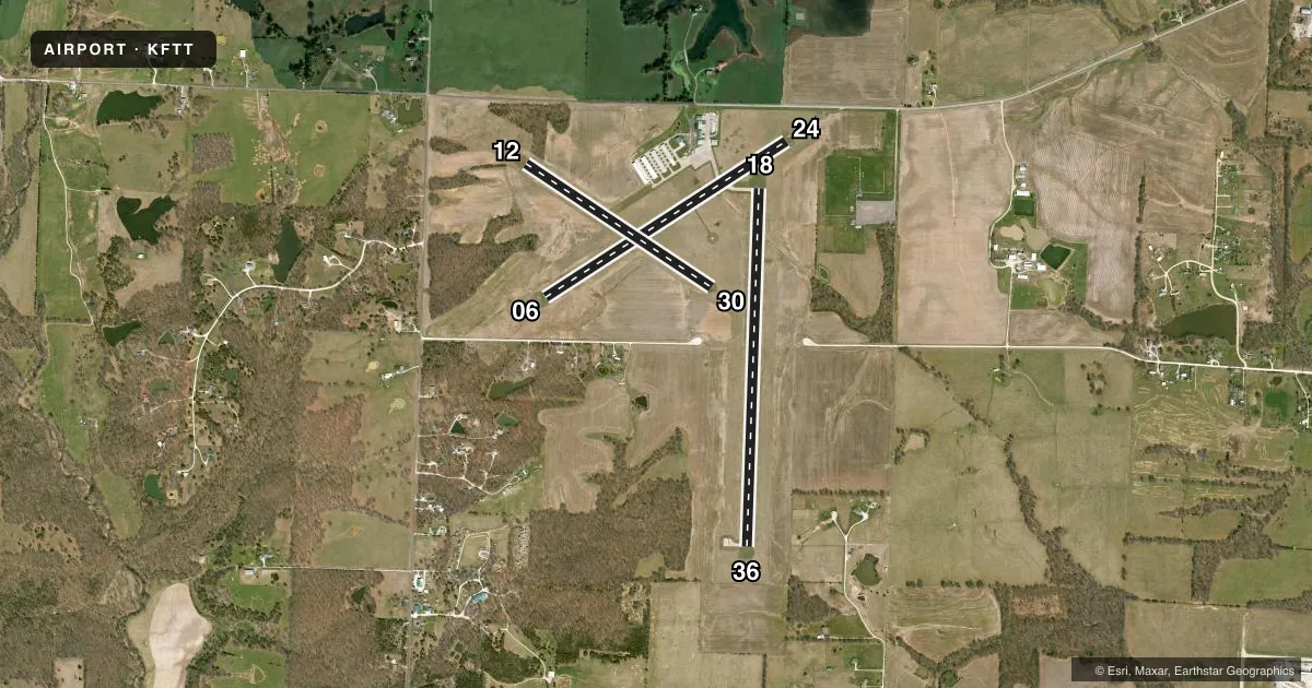
Runways & pattern
Full pagePattern entry · RWY 18
LEFT TRAFFIC| Runway | Heading (°M) | Length | Surface | Traffic |
|---|---|---|---|---|
| 18/36Favored | 180° / 0° | 4,001 ft | CONC | Standard L |
| 06/24 | 56° / 236° | 3,203 ft | CONC | Standard L |
| 12/30 | 123° / 303° | 2,488 ft | TURF | Standard L |
Runway end performance
| End | TORA | TODA | ASDA | LDA | VGSI | Approach lights | Obstruction |
|---|---|---|---|---|---|---|---|
| 18 | — | — | — | — | PAPI 4-box left(3°) | — | — |
| 36 | — | — | — | — | PAPI 4-box left(3°) | — | 50', trees, 1215' from thr, 270' R of cntrln, slope 20 |
| 06 | — | — | — | — | PAPI 2-box left(3°) | — | — |
| 24 | — | — | — | — | PAPI 2-box left(4°) | — | 15', road, 315' from thr, 250' R of cntrln, slope 7 |
Declared distances in feet. TORA = takeoff run available, TODA = takeoff distance, ASDA = accelerate-stop, LDA = landing distance.
Airport sketch
Runways drawn to scale from FAA survey coordinates, rendered over satellite imagery. Not for navigation.
Approaches & charts
Services on the field
Fuel grades, oxygen, maintenance, ramp storage and lighting — as declared to the FAA by the airport operator.
Fuel & services
- Fuel
- 100LL
- Airframe repair
- Major
- Power plant repair
- Major
- Other services
- CHTR,INSTR,RNTL,SURV
Ramp & ground
- Transient storage
- Tie-down
- Hangar
- Landing fee
- No fee published
- Customs
- Not available
- Lighting schedule
- SEE RMK
- Beacon schedule
- SS-SR
- Beacon
- White / Green (civil land)(WG)
- Wind indicator
- Lighted
- Segmented circle
- Yes
Fuel & FBOs
Cheapest 100LL and Jet A on the field and nearby. Always confirm with the FBO before taxi.
Airport notes
Surface conditions, obstructions, local procedures, lighting outages and other notes published with each FAA cycle.
General notes
- FOR CD CTC MIZZOU APCH AT 417-868-5620/5619.
Lighting notes
- ACTVT REIL RWY 06, 24, 18 & 36; PAPI RWY 06, 24, 18 & 36; MIRL RWY 06, 24, 18 & 36 - CTAF.
Approach & departure obstructions
- 1212/30 MARKED WTH LARGE YELLOW CONES.
Other notes
- MANAGERAMGR CELL: 573-544-6906. AFTER HOURS CONTACT CITY OF FULTON POWER PLANT: 573-592-3180
VFR map & nearby airports
VFR sectional. Tap any ICAO chip to open that airport.
Key facts · KFTT
Answer card- ICAO
- KFTT
- Name
- ELTON HENSLEY MEML
- Location
- FULTON, MISSOURI
- Elevation
- 886.6 ft MSL
- Traffic pattern altitude
- 1,886.6 ft MSL (1,000 AGL)
- Control tower
- Non-towered (use CTAF)
- Total runways
- 3
- Longest runway
- 18/36 · 4,001 ft
- Published ILS approaches
- 0
- Published frequencies
- 4
- Magnetic variation
- 1°
- Current flight rules
- VFR
- Current wind
- 180° at 6 kt
- Favored runway now
- RWY 18
Elton Hensley Memorial Airport sits in Fulton, Missouri. Field elevation is 886.6 ft MSL. The airport has three runways. The longest is 18/36 at 4,001 ft. This is a non-towered field, so expect self-announce traffic on CTAF 122.7. No ILS approaches are published here. Pattern altitude is not published, so use the standard 1,000 ft AGL for light piston aircraft unless the current Chart Supplement says otherwise.
The paved runways are 18/36 at 4,001 ft and 06/24 at 3,203 ft. Runway 12/30 is turf at 2,488 ft. The published remarks say 06, 24, 18 and 36 have runway end identifier lights, PAPI and medium intensity runway lights that are activated on CTAF. Runways 12 and 30 are marked with large yellow cones. That makes the paved runways the ones most pilots will want to plan around.
Elton Hensley Memorial Airport is the on-field FBO. It carries 100LL. Call ahead if you want current ramp details or service status. For clearance delivery, Mizzou Approach is listed in the remarks. Pilots should also check the current Chart Supplement for any local procedures before arrival. The field is in the Fulton area, so expect normal Midwest general aviation traffic rather than towered sequencing.