METAR & TAF H79
H79 does not publish a METAR.
Showing the nearest reporting station: KAIZ (LEE C FINE MEML) · 16.0 NM away. Conditions at H79 may differ.
METAR · KAIZ
Observed 16:56Z
KAIZ 271656Z AUTO 22010G18KT 10SM CLR 36/22 A2992 RMK AO2 SLP116 T03560222 $
- Wind
- 220° @ 10G18 kt
- Visibility
- 10 SM
- Temp / Dew
- 36°C / 22°C
- Altimeter
- 29.92 inHg
- Clouds
- CLR
- Density alt
- 3,657 ft
- Ceiling
- Unlimited
- Rules
- VFR
Airport info & contacts
Manager on record, flight service, ARTCC, attendance schedule and pattern altitude — published by the FAA and refreshed every 28 days.
Location
- From city
- 1 NM NE
- VFR sectional
- KANSAS CITY
- ARTCC
- ZKC · KANSAS CITY
- NOTAM facility
- COU (NOTAM-D)
Airport manager
- Name
- MANDY ASBURY
- Phone
- 573-392-2291
- Address
- 101 SOUTH OAK ST BOX 355, ELDON MO 65026
Flight service · Hours
- FSS COU
- COLUMBIA1-800-WX-BRIEF
- Attendance
- Unattended
Frequencies
Tap any row to copy the frequency to your clipboard.
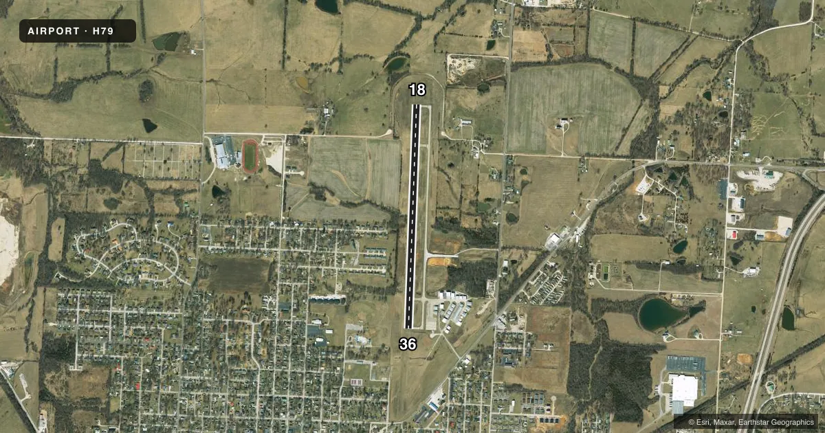
Runways & pattern
Full pagePattern entry · RWY 18
LEFT TRAFFICRunway end performance
| End | TORA | TODA | ASDA | LDA | VGSI | Approach lights | Obstruction |
|---|---|---|---|---|---|---|---|
| 18 | — | — | — | — | PAPI 4-box right(3°) | — | — |
| 36 | — | — | — | — | PAPI 4-box left(4°) | — | — |
Declared distances in feet. TORA = takeoff run available, TODA = takeoff distance, ASDA = accelerate-stop, LDA = landing distance.
Airport sketch
Runways drawn to scale from FAA survey coordinates, rendered over satellite imagery. Not for navigation.
Approaches & charts
Services on the field
Fuel grades, oxygen, maintenance, ramp storage and lighting — as declared to the FAA by the airport operator.
Fuel & services
- Fuel
- 100LLA+
- Oxygen (bottled)
- Not available
- Oxygen (bulk)
- Not available
Ramp & ground
- Transient storage
- Tie-down
- Hangar
- Landing fee
- No fee published
- Customs
- Not available
- Lighting schedule
- SEE RMK
- Beacon schedule
- SS-SR
- Beacon
- White / Green (civil land)(WG)
- Wind indicator
- Lighted
- Segmented circle
- Yes
Fuel & FBOs
Cheapest 100LL and Jet A on the field and nearby. Always confirm with the FBO before taxi.
Airport notes
Surface conditions, obstructions, local procedures, lighting outages and other notes published with each FAA cycle.
General notes
- GEESE & OTHER WILDLIFE ON & INVOF ARPT.
- FOR CD CTC MIZZOU APCH AT 417-868-5620/5619.
Lighting notes
- ACTVT MIRL RWY 18/36; REIL RWYS 18/36; PAPI RWYS 18/36 - CTAF.
- ULTRALIGHTS ON & INVOF ARPT.
Fuel notes
- 100LLAUTO CREDIT CARD FUELING SYS 24 HRS A DAY 100LL, JET A.
Other notes
- UNICOM UNMON.
VFR map & nearby airports
VFR sectional. Tap any ICAO chip to open that airport.
Key facts · H79
Answer card- ICAO
- H79
- Name
- ELDON MODEL AIRPARK
- Location
- ELDON, MISSOURI
- Elevation
- 917.2 ft MSL
- Traffic pattern altitude
- 1,917.2 ft MSL (1,000 AGL)
- Control tower
- Non-towered (use CTAF)
- Total runways
- 1
- Longest runway
- 18/36 · 4,000 ft
- Published ILS approaches
- 0
- Published frequencies
- 4
- Magnetic variation
- 0°
- Current flight rules
- VFR
- Current wind
- 220° at 10 kt
- Favored runway now
- RWY 18
Eldon Model Airpark sits in Eldon, Missouri. The field elevation is 917.2 ft MSL. It has one runway. The longest runway is 4,000 ft of concrete. There is no control tower. Pattern altitude is not published, so use the standard 1,000 ft AGL for light piston traffic unless the current Chart Supplement says otherwise.
No ILS approaches are published here. The runway lighting is useful after dark. Medium intensity runway lights serve 18/36. Runway end identifier lights are installed on both ends. PAPI is available on 18 and 36. It is activated by the CTAF. CTAF and UNICOM are both 122.8. UNICOM is unmonitored.
For fuel, there is an automatic credit card system on the field for 100LL and Jet A. No on-field FBOs are listed. For clearance delivery, Mizzou Approach is the contact listed in the remarks. Expect ultralight activity in and around the airport. Geese and other wildlife are also noted nearby. That matters here. Keep a sharp scan on short final and during taxi. If you need current operating details, check the current FAA Chart Supplement or call the airport operator directly.