METAR & TAF 3VS
3VS does not publish a METAR.
Showing the nearest reporting station: KDMO (SEDALIA RGNL) · 21.9 NM away. Conditions at 3VS may differ.
METAR · KDMO
Observed 12:53Z
KDMO 271253Z AUTO 21009KT 10SM CLR 28/22 A2991 RMK AO2 SLP116 T02780222
- Wind
- 210° @ 9 kt
- Visibility
- 10 SM
- Temp / Dew
- 28°C / 22°C
- Altimeter
- 29.91 inHg
- Clouds
- CLR
- Density alt
- 2,846 ft
- Ceiling
- Unlimited
- Rules
- VFR
Airport info & contacts
Manager on record, flight service, ARTCC, attendance schedule and pattern altitude — published by the FAA and refreshed every 28 days.
Location
- From city
- 2 NM W
- VFR sectional
- KANSAS CITY
- ARTCC
- ZKC · KANSAS CITY
- NOTAM facility
- COU (NOTAM-D)
Airport manager
- Name
- JAMIE MORROW
- Phone
- 573-378-4634
- Address
- 104 N. FISHER ST, 10998 HIGHWAY 52, VERSAILLES MO 65084
Flight service · Hours
- FSS COU
- COLUMBIA1-800-WX-BRIEF
- Attendance
- 0800-1700
Frequencies
Tap any row to copy the frequency to your clipboard.
Runways & pattern
Full pagePattern entry · RWY 25
RIGHT TRAFFICRunway end performance
| End | TORA | TODA | ASDA | LDA | VGSI | Approach lights | Obstruction |
|---|---|---|---|---|---|---|---|
| 07 | — | — | — | — | — | — | 63', trees, 631' from thr, 87' R of cntrln, slope 6 |
| 25 | — | — | — | — | — | — | 77', trees, 1145' from thr, 225' R of cntrln, slope 12 |
Declared distances in feet. TORA = takeoff run available, TODA = takeoff distance, ASDA = accelerate-stop, LDA = landing distance.
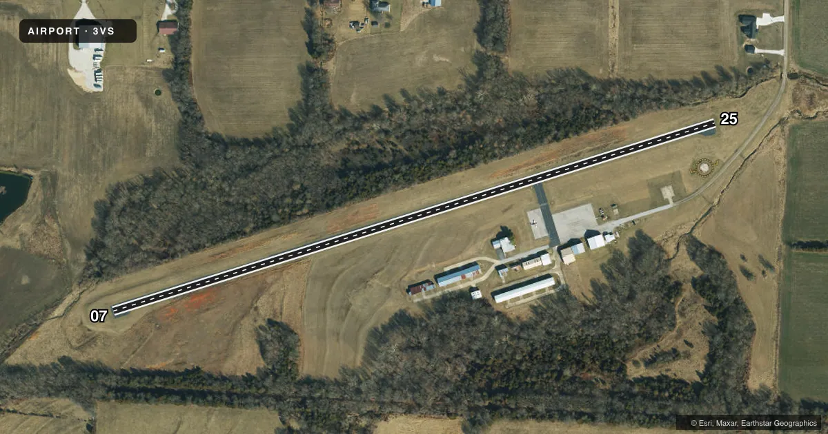
Airport sketch
Runways drawn to scale from FAA survey coordinates, rendered over satellite imagery. Not for navigation.
Approaches & charts
Services on the field
Fuel grades, oxygen, maintenance, ramp storage and lighting — as declared to the FAA by the airport operator.
Fuel & services
- Fuel
- 100LL
- Oxygen (bottled)
- Not available
- Oxygen (bulk)
- Not available
- Airframe repair
- Not available
- Power plant repair
- Not available
Ramp & ground
- Transient storage
- Tie-down
- Landing fee
- No fee published
- Customs
- Not available
- Lighting schedule
- SEE RMK
- Beacon schedule
- SS-SR
- Beacon
- White / Green (civil land)(WG)
- Wind indicator
- Lighted
- Segmented circle
- Yes
Fuel & FBOs
Cheapest 100LL and Jet A on the field and nearby. Always confirm with the FBO before taxi.
Airport notes
Surface conditions, obstructions, local procedures, lighting outages and other notes published with each FAA cycle.
General notes
- CROP DUSTING ACFT AND HELICOPTERS; AND ULTRALIGHT ACTIVITY ON AND INVOF ARPT.
- DEER & WILDLIFE ON & INVOF ARPT.
- RY 07/25 LINE OF SIGHT OBSTRUCTED BY GRADE CHANGE IN RY.
- NTSD RY SAFETY AREA BYND EACH RY END; INCORRECT TERRAIN GRADES, LARGE DROP OFF AT RY 07 END, ROAD AT RY 25 END.
- FOR CD CTC WHITEMAN APCH AT 660-687-3132. WHEN WHITEMAN APCH IS CLSD, CTC KANSAS CITY ARTCC AT 913-254-8508.
Lighting notes
- ACTVT MIRL RY 07/25 - CTAF, CLICK 3 TIMES.
Fuel notes
- 100LLFUEL AVBL 24 HRS SELF-SVC.
Runway surface & condition
- 07/25WIDTH VARIANCE 39-40 FT.
Approach & departure obstructions
- 258 FT ROAD 105-200 FT FM RWY END 40-125L;
Other notes
- MANAGERAFTER HOURS NON-EMERGENCY: 573-378-0623
VFR map & nearby airports
VFR sectional. Tap any ICAO chip to open that airport.
Key facts · 3VS
Answer card- ICAO
- 3VS
- Name
- ROY OTTEN MEML AIRFIELD
- Location
- VERSAILLES, MISSOURI
- Elevation
- 1,027 ft MSL
- Traffic pattern altitude
- 2,027 ft MSL (1,000 AGL)
- Control tower
- Non-towered (use CTAF)
- Total runways
- 1
- Longest runway
- 07/25 · 2,805 ft
- Published ILS approaches
- 0
- Published frequencies
- 2
- Magnetic variation
- 4°
- Current flight rules
- VFR
- Current wind
- 210° at 9 kt
- Favored runway now
- RWY 25
Roy Otten Meml Airfield is in Versailles, Missouri. The field elevation is 1,027 ft MSL. It has one runway. Runway 07/25 is 2,805 ft long with an asphalt surface. The airport is nontowered. CTAF and UNICOM are both 122.8. No ILS approaches are published here.
Pattern altitude is not published. Use the standard 1,000 ft AGL pattern for light piston traffic unless the current Chart Supplement says otherwise. 100LL is available 24 hours through self-service. After-hours non-emergency contact is 573-378-0623.
First-time pilots should pay close attention to the runway notes. Line of sight along 07/25 is affected by a grade change in the runway. There is also a road near the runway 25 end. The published remarks say there is no standard runway safety area beyond either end. Deer and wildlife are present on and near the airport. Crop dusting aircraft, helicopters and ultralight activity also operate in the area. Runway lights on 07/25 are medium intensity. They are activated by clicking the CTAF frequency three times. For clearance delivery, contact Whiteman Approach at 660-687-3132. When Whiteman Approach is closed, contact Kansas City ARTCC at 913-254-8508.