METAR & TAF KRAW
Current METAR
Observed 16:15Z
KRAW 271615Z AUTO 22010KT 10SM CLR 33/21 A2991 RMK AO2 T03270211
- Wind
- 220° @ 10 kt
- Visibility
- 10 SM
- Temp / Dew
- 33°C / 21°C
- Altimeter
- 29.91 inHg
- Clouds
- CLR
- Density alt
- 3,333 ft
- Ceiling
- Unlimited
- Rules
- VFR
Airport info & contacts
Manager on record, flight service, ARTCC, attendance schedule and pattern altitude — published by the FAA and refreshed every 28 days.
Location
- From city
- 6 NM N
- VFR sectional
- KANSAS CITY
- ARTCC
- ZKC · KANSAS CITY
- NOTAM facility
- COU (NOTAM-D)
Airport manager
- Name
- RANDY POGUE
- Phone
- 660-438-5522
- Address
- P.O. BOX 68, 181 W. HARRISON, WARSAW MO 65355
Flight service · Hours
- FSS COU
- COLUMBIA1-800-WX-BRIEF
- Attendance
- Unattended
Frequencies
Tap any row to copy the frequency to your clipboard.
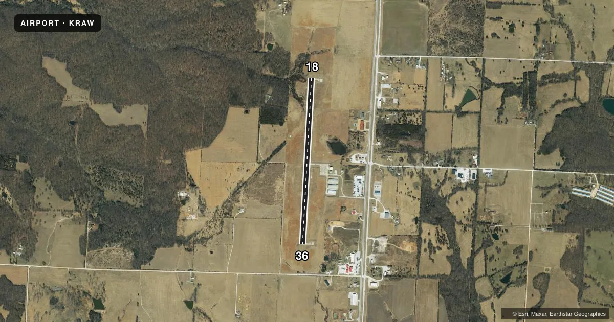
Runways & pattern
Full pagePattern entry · RWY 18
LEFT TRAFFICRunway end performance
| End | TORA | TODA | ASDA | LDA | VGSI | Approach lights | Obstruction |
|---|---|---|---|---|---|---|---|
| 18 | — | — | — | — | PAPI 4-box left(3°) | — | — |
| 36 | — | — | — | — | PAPI 4-box left(3°) | — | — |
Declared distances in feet. TORA = takeoff run available, TODA = takeoff distance, ASDA = accelerate-stop, LDA = landing distance.
Airport sketch
Runways drawn to scale from FAA survey coordinates, rendered over satellite imagery. Not for navigation.
Approaches & charts
Services on the field
Fuel grades, oxygen, maintenance, ramp storage and lighting — as declared to the FAA by the airport operator.
Fuel & services
- Fuel
- 100LL
- Oxygen (bottled)
- Not available
- Oxygen (bulk)
- Not available
- Airframe repair
- Major
- Power plant repair
- Major
- Other services
- AGRI,AVNCS,INSTR,RNTL,SURV
Ramp & ground
- Transient storage
- Tie-down
- Lighting schedule
- SEE RMK
- Beacon schedule
- SS-SR
- Beacon
- White / Green (civil land)(WG)
- Wind indicator
- Lighted
- Segmented circle
- Yes
Fuel & FBOs
Cheapest 100LL and Jet A on the field and nearby. Always confirm with the FBO before taxi.
Airport notes
Surface conditions, obstructions, local procedures, lighting outages and other notes published with each FAA cycle.
General notes
- WILDLIFE ON & INVOF ARPT.
- FOR CD CTC WHITEMAN APCH AT 660-687-3132. WHEN WHITEMAN APCH IS CLSD, CTC KANSAS CITY ARTCC AT 913-254-8508.
Lighting notes
- ACTVT REIL RWYS 18 & 36; PAPI RWYS 18 & 36; MIRL RWYS 18 & 36 - CTAF.
Fuel notes
- 100LLFUEL AVBL 24 HRS SELF-SVC.
Other notes
- PER TELCON WITH GLEN HELM ACE-625.
VFR map & nearby airports
VFR sectional. Tap any ICAO chip to open that airport.
Key facts · KRAW
Answer card- ICAO
- KRAW
- Name
- WARSAW MUNI
- Location
- WARSAW, MISSOURI
- Elevation
- 936.1 ft MSL
- Traffic pattern altitude
- 1,936.1 ft MSL (1,000 AGL)
- Control tower
- Non-towered (use CTAF)
- Total runways
- 1
- Longest runway
- 18/36 · 4,000 ft
- Published ILS approaches
- 0
- Published frequencies
- 5
- Magnetic variation
- 1°
- Current flight rules
- VFR
- Current wind
- 220° at 10 kt
- Favored runway now
- RWY 18
Warsaw Muni sits in Warsaw, Missouri. Field elevation is 936.1 ft MSL. The airport has one runway, 18/36, which is 4,000 ft long. It is a non-towered field. Use CTAF 122.9 for local traffic calls. No ILS approaches are published here.
The published pattern altitude is not listed in the facts. For light piston operations, use the standard 1,000 ft AGL unless the current Chart Supplement says otherwise. The airport is in the Whiteman area, so clearance delivery goes through Whiteman Approach when it is open. When Whiteman Approach is closed, contact Kansas City ARTCC before departure. Runway 18 and 36 have edge lighting, runway end identifier lights and PAPI. That helps for night work and arrivals in lower visibility.
Warsaw Municipal Airport is the on-field FBO. It carries 100LL. Self-serve 100LL is available 24 hours. Wildlife is noted on and near the airport. Expect a careful scan on taxi, takeoff and landing. If you need current noise, airspace, or operating details beyond these published facts, check the current FAA Chart Supplement or call the airport operator or FBO directly.