METAR & TAF KDMO
Current METAR
Observed 10:53Z
KDMO 271053Z AUTO 21008KT 10SM CLR 26/22 A2990 RMK AO2 SLP113 T02610222
- Wind
- 210° @ 8 kt
- Visibility
- 10 SM
- Temp / Dew
- 26°C / 22°C
- Altimeter
- 29.90 inHg
- Clouds
- CLR
- Density alt
- 2,473 ft
- Ceiling
- Unlimited
- Rules
- VFR
Airport info & contacts
Manager on record, flight service, ARTCC, attendance schedule and pattern altitude — published by the FAA and refreshed every 28 days.
Location
- From city
- 2 NM E
- VFR sectional
- KANSAS CITY
- ARTCC
- ZKC · KANSAS CITY
- NOTAM facility
- DMO (NOTAM-D)
Airport manager
- Name
- MITCHELL MULLEN
- Phone
- 660-826-4128
- Address
- 1900 E BOONEVILLE, SEDALIA MO 65301
Flight service · Hours
- FSS COU
- COLUMBIA1-800-WX-BRIEF
- Attendance
- MON-FRI · 0700-1800
- SAT-SUN · 0800-1800
Frequencies
Tap any row to copy the frequency to your clipboard.
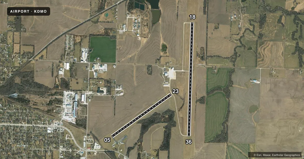
Runways & pattern
Full pagePattern entry · RWY 23
RIGHT TRAFFIC| Runway | Heading (°M) | Length | Surface | Traffic |
|---|---|---|---|---|
| 18/36 | 179° / 359° | 5,500 ft | CONC | 36 R |
| 05/23Favored | 51° / 231° | 3,519 ft | ASPH | 23 R |
Runway end performance
| End | TORA | TODA | ASDA | LDA | VGSI | Approach lights | Obstruction |
|---|---|---|---|---|---|---|---|
| 18 | — | — | — | — | PAPI 4-box left(3°) | — | — |
| 36 | — | — | — | — | PAPI 4-box left(3°) | — | — |
| 05 | — | — | — | — | — | — | 54', tree, 615' from thr, 270' R of cntrln, slope 7 |
| 23 | — | — | — | — | — | — | 15', brush, 243' from thr, 125' R of cntrln, slope 2 |
Declared distances in feet. TORA = takeoff run available, TODA = takeoff distance, ASDA = accelerate-stop, LDA = landing distance.
Airport sketch
Runways drawn to scale from FAA survey coordinates, rendered over satellite imagery. Not for navigation.
Approaches & charts
Services on the field
Fuel grades, oxygen, maintenance, ramp storage and lighting — as declared to the FAA by the airport operator.
Fuel & services
- Fuel
- 100LLA
- Oxygen (bottled)
- Not available
- Oxygen (bulk)
- HIGH/LOW
- Airframe repair
- Major
- Power plant repair
- Major
- Other services
- AGRI,INSTR,RNTL
Ramp & ground
- Transient storage
- Tie-down
- Landing fee
- No fee published
- Customs
- Not available
- Lighting schedule
- SEE RMK
- Beacon schedule
- SS-SR
- Beacon
- White / Green (civil land)(WG)
- Wind indicator
- Lighted
- Segmented circle
- Yes
Fuel & FBOs
Cheapest 100LL and Jet A on the field and nearby. Always confirm with the FBO before taxi.
Airport notes
Surface conditions, obstructions, local procedures, lighting outages and other notes published with each FAA cycle.
General notes
- WILDLIFE ON RYS EARLY MORNING & DUSK.
- 100LL SELF SERVICE AVBL 24/7
- JET A AVBL AFTER HOURS - $80 FEE - CALL 660-826-8100
- FOR CD IF UNA TO CTC ON FSS FREQ, CTC WHITEMAN APCH AT 660-687-3132. WHEN WHITEMAN APCH IS CLSD, CTC KANSAS CITY ARTCC AT 913-254-8508.
Lighting notes
- ACTVT REIL RWY 18 & 36; MIRL RWY 18/36 & 05/23 - CTAF. PAPI RWY 18 & 36 ON 24 HRS.
Approach & departure obstructions
- 23BRUSH 5-6 FT TALL 130-200 FT FM THR 130 FT RIGHT.
Other notes
- ARMY NATIONAL GUARD TRAINING.
VFR map & nearby airports
VFR sectional. Tap any ICAO chip to open that airport.
Key facts · KDMO
Answer card- ICAO
- KDMO
- Name
- SEDALIA RGNL
- Location
- SEDALIA, MISSOURI
- Elevation
- 909.7 ft MSL
- Traffic pattern altitude
- 1,909.7 ft MSL (1,000 AGL)
- Control tower
- Non-towered (use CTAF)
- Total runways
- 2
- Longest runway
- 18/36 · 5,500 ft
- Published ILS approaches
- 0
- Published frequencies
- 6
- Magnetic variation
- 3°
- Current flight rules
- VFR
- Current wind
- 210° at 8 kt
- Favored runway now
- RWY 23
Sedalia Rgnl is in Sedalia, Missouri. The field elevation is 909.7 ft MSL. It has two runways. The longest is 5,500 ft. There is no control tower, so expect non-towered procedures on CTAF 122.8. No ILS approaches are published here. The pattern altitude is not published in the facts, so use the standard 1,000 ft AGL for light piston traffic unless the current FAA Chart Supplement says otherwise.
The on-field FBO is Sedalia Regional Airport. It carries 100LL and Jet A Prist. 100LL self-serve is available 24 hours a day, 7 days a week. Jet A is available after hours with a fee, so call ahead if you need late fuel service. Runway 18 and 36 have runway end identifier lights, medium intensity lights and PAPI. Those lights are controlled by CTAF. The airport also sees Army National Guard training, so expect some military traffic in the area. Wildlife is reported on the runways early morning and at dusk. Runway 23 has a brush obstruction near the threshold on the right side. Brief that on departure and landing from that end.