METAR & TAF KMHL
Current METAR
Observed 13:35Z
KMHL 271335Z AUTO 21007KT 10SM CLR 27/23 A2989 RMK AO2
- Wind
- 210° @ 7 kt
- Visibility
- 10 SM
- Temp / Dew
- 27°C / 23°C
- Altimeter
- 29.89 inHg
- Clouds
- CLR
- Density alt
- 2,443 ft
- Ceiling
- Unlimited
- Rules
- VFR
Airport info & contacts
Manager on record, flight service, ARTCC, attendance schedule and pattern altitude — published by the FAA and refreshed every 28 days.
Location
- From city
- 2 NM S
- VFR sectional
- KANSAS CITY
- ARTCC
- ZKC · KANSAS CITY
- NOTAM facility
- COU (NOTAM-D)
Airport manager
- Name
- MUNI SERVICE DEPT
- Phone
- 660-886-9855
- Address
- 1277 S. ODELL, MARSHALL MO 65340
Flight service · Hours
- FSS COU
- COLUMBIA1-800-WX-BRIEF
- Attendance
- APR-SEP · 0700-1800
- OCT-MAR · 0700-1700
Frequencies
Tap any row to copy the frequency to your clipboard.
Runways & pattern
Full pagePattern entry · RWY 18
LEFT TRAFFIC| Runway | Heading (°M) | Length | Surface | Traffic |
|---|---|---|---|---|
| 18/36Favored | 178° / 358° | 5,005 ft | CONC | Standard L |
| 09/27 | 93° / 273° | 3,303 ft | TURF | 09 R |
Runway end performance
| End | TORA | TODA | ASDA | LDA | VGSI | Approach lights | Obstruction |
|---|---|---|---|---|---|---|---|
| 18 | — | — | — | — | PAPI 4-box left(3.05°) | — | 61', trees, 1085' from thr, 375' R of cntrln, slope 14 |
| 36 | — | — | — | — | PAPI 4-box left(3.04°) | — | — |
Declared distances in feet. TORA = takeoff run available, TODA = takeoff distance, ASDA = accelerate-stop, LDA = landing distance.
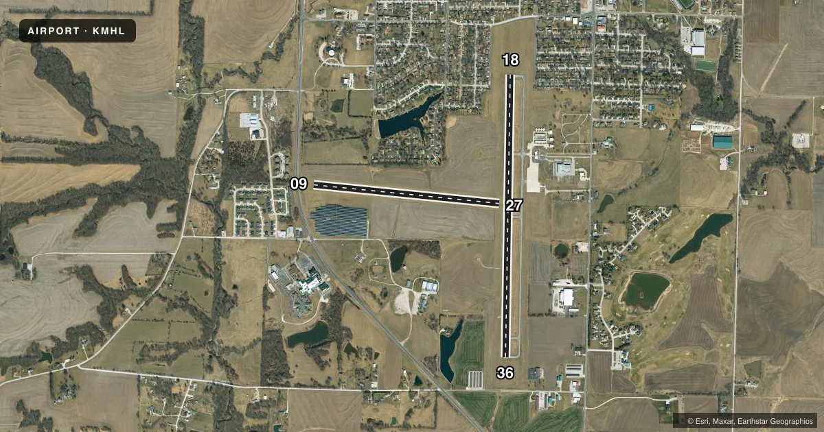
Airport sketch
Runways drawn to scale from FAA survey coordinates, rendered over satellite imagery. Not for navigation.
Approaches & charts
Services on the field
Fuel grades, oxygen, maintenance, ramp storage and lighting — as declared to the FAA by the airport operator.
Fuel & services
- Fuel
- 100LLA1+
- Oxygen (bottled)
- Not available
- Oxygen (bulk)
- Not available
- Airframe repair
- Minor
- Power plant repair
- Minor
- Other services
- AGRI,INSTR,RNTL
Ramp & ground
- Transient storage
- Tie-down
- Landing fee
- No fee published
- Customs
- Not available
- Lighting schedule
- SEE RMK
- Beacon schedule
- SS-SR
- Beacon
- White / Green (civil land)(WG)
- Wind indicator
- Lighted
- Segmented circle
- Yes
Fuel & FBOs
Cheapest 100LL and Jet A on the field and nearby. Always confirm with the FBO before taxi.
Airport notes
Surface conditions, obstructions, local procedures, lighting outages and other notes published with each FAA cycle.
General notes
- HVY SEASONAL AG SPRAY ACFT OPNS ON & INVOF ARPT.
- FOR CD CTC WHITEMAN APCH AT 660-687-3132. WHEN WHITEMAN APCH IS CLSD, CTC KANSAS CITY ARTCC AT 913-254-8508.
Lighting notes
- ACTVT MIRL RY 18/36; PAPI RYS 18 & 36 AND REIL RY 36- CTAF.
Fuel notes
- 100LL100LL AND JET A1+ SELF SERVICE AVBL 24 HRS.
Approach & departure obstructions
- 09RY 09/27 MKD WITH LARGE YELLOW CONES.
- 18RWY 18 APCH SLOPE 22:1 TO DSPLCD THR.
Other notes
- PROVIDED A CLEAR APCH TO EA RY MAINTAINED FOR A 20:1 GLIDE SLOPE; A CLEAR TRANSITIONAL SFC MAINTAINED FOR A 7:1 SLOPE; A RIGHT TFC PATTERN ESTABLISHED TO RY 09; THE ALP UPDATED & COORDINATION OF NEW RY WITH MHTD.
VFR map & nearby airports
VFR sectional. Tap any ICAO chip to open that airport.
Key facts · KMHL
Answer card- ICAO
- KMHL
- Name
- MARSHALL MEML MUNI
- Location
- MARSHALL, MISSOURI
- Elevation
- 778.9 ft MSL
- Traffic pattern altitude
- 1,778.9 ft MSL (1,000 AGL)
- Control tower
- Non-towered (use CTAF)
- Total runways
- 2
- Longest runway
- 18/36 · 5,005 ft
- Published ILS approaches
- 0
- Published frequencies
- 4
- Magnetic variation
- 3°
- Current flight rules
- VFR
- Current wind
- 210° at 7 kt
- Favored runway now
- RWY 18
Marshall Meml Muni sits in Marshall, Missouri. The field elevation is 778.9 ft MSL. It has two runways. The longest is 5,005 ft of concrete on 18/36. The turf runway 09/27 is 3,303 ft. The airport is non-towered. CTAF and UNICOM are both 122.8. No ILS approaches are published here.
Pattern altitude is not published. Use the standard 1,000 ft AGL for light piston traffic unless the current Chart Supplement says otherwise. That puts the pattern at about 1,779 ft MSL. Right traffic is established for runway 09. Runway 09 and 27 are marked with large yellow cones. Runway 18 has a displaced-threshold note in the published remarks. The approach slope to that threshold is steep, so plan your descent early.
Marshall Municipal Airport is the on-field FBO. It carries AVGAS 100LL and Jet A. The published remarks also say 100LL and Jet A1+ self-serve are available 24 hours. Medium intensity runway lights are active on 18/36. PAPI is installed on 18 and 36. Runway 36 has runway end identifier lights.
One thing to watch here is seasonal ag spray traffic. That can mean low-level maneuvering near the airport. For clearances, contact Whiteman Approach when it is open. If it is closed, use Kansas City Center. Check the current FAA Chart Supplement before you go for any changes to remarks or local procedures.