METAR & TAF KHIG
KHIG does not publish a METAR.
Showing the nearest reporting station: KRCM (SKYHAVEN) · 18.3 NM away. Conditions at KHIG may differ.
METAR · KRCM
Observed 17:35Z
KRCM 271735Z AUTO 18008KT 10SM CLR 33/22 A2985 RMK AO2
- Wind
- 180° @ 8 kt
- Visibility
- 10 SM
- Temp / Dew
- 33°C / 22°C
- Altimeter
- 29.85 inHg
- Clouds
- CLR
- Density alt
- 3,288 ft
- Ceiling
- Unlimited
- Rules
- VFR
Airport info & contacts
Manager on record, flight service, ARTCC, attendance schedule and pattern altitude — published by the FAA and refreshed every 28 days.
Location
- From city
- 2 NM E
- VFR sectional
- KANSAS CITY
- ARTCC
- ZKC · KANSAS CITY
- NOTAM facility
- COU (NOTAM-D)
Airport manager
- Name
- SCOTT MCCORMICK
- Phone
- 618-420-9046
- Address
- 11667 AIRPORT ROAD, HIGGINSVILLE MO 64037
Flight service · Hours
- FSS COU
- COLUMBIA1-800-WX-BRIEF
- Attendance
- SEP-APR · 0800-1700
- MAY-AUG · 0700-1900
Frequencies
Tap any row to copy the frequency to your clipboard.
Runways & pattern
Full pagePattern entry · RWY 16
LEFT TRAFFICRunway end performance
| End | TORA | TODA | ASDA | LDA | VGSI | Approach lights | Obstruction |
|---|---|---|---|---|---|---|---|
| 16 | 4,400' | 4,400' | 4,400' | 4,400' | PAPI 4-box left(3°) | — | — |
| 34 | 4,400' | 4,400' | 4,400' | 4,400' | PAPI 4-box left(3°) | — | 27', tree, 750' from thr, 320' R of cntrln, slope 20 |
Declared distances in feet. TORA = takeoff run available, TODA = takeoff distance, ASDA = accelerate-stop, LDA = landing distance.
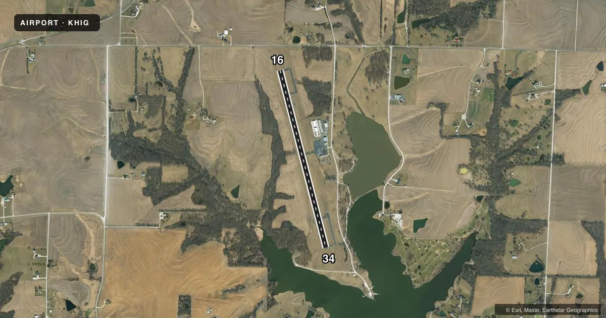
Airport sketch
Runways drawn to scale from FAA survey coordinates, rendered over satellite imagery. Not for navigation.
Approaches & charts
Services on the field
Fuel grades, oxygen, maintenance, ramp storage and lighting — as declared to the FAA by the airport operator.
Fuel & services
- Fuel
- 100LL
- Oxygen (bottled)
- Not available
- Oxygen (bulk)
- Not available
- Airframe repair
- Not available
- Power plant repair
- Not available
- Other services
- AVNCS,SALES
Ramp & ground
- Transient storage
- Tie-down
- Hangar
- Landing fee
- No fee published
- Customs
- Not available
- Lighting schedule
- SEE RMK
- Beacon schedule
- SS-SR
- Beacon
- White / Green (civil land)(WG)
- Wind indicator
- Lighted
- Segmented circle
- No
Fuel & FBOs
Cheapest 100LL and Jet A on the field and nearby. Always confirm with the FBO before taxi.
Airport notes
Surface conditions, obstructions, local procedures, lighting outages and other notes published with each FAA cycle.
General notes
- WILDLIFE ON & INVOF ARPT.
- EXTENSIVE HELICOPTER OPERATIONS.
- FOR CD CTC WHITEMAN APCH AT 660-687-3132. WHEN WHITEMAN APCH IS CLSD, CTC KANSAS CITY ARTCC AT 913-254-8508.
Lighting notes
- ACTVT MIRL RY 16/34; PAPI & REIL RYS 16 & 34 - CTAF.
Fuel notes
- 100LLFOR SVC AFT HRS, CALL NBRS POSTED ON TERMINAL DOOR.
VFR map & nearby airports
VFR sectional. Tap any ICAO chip to open that airport.
Key facts · KHIG
Answer card- ICAO
- KHIG
- Name
- HIGGINSVILLE INDUSTRIAL MUNI
- Location
- HIGGINSVILLE, MISSOURI
- Elevation
- 840 ft MSL
- Traffic pattern altitude
- 1,840 ft MSL (1,000 AGL)
- Control tower
- Non-towered (use CTAF)
- Total runways
- 1
- Longest runway
- 16/34 · 4,400 ft
- Published ILS approaches
- 0
- Published frequencies
- 6
- Magnetic variation
- 2°
- Current flight rules
- VFR
- Current wind
- 180° at 8 kt
- Favored runway now
- RWY 16
Higginsville Industrial Muni is in Higginsville, Missouri. The field elevation is 840 ft MSL. It has one runway. Runway 16/34 is 4,400 ft long with an asphalt surface. There is no control tower. No ILS approaches are published here.
Pattern altitude is not published. Use 1,000 ft AGL as the standard light piston pattern unless the current Chart Supplement says otherwise. The airport sits under Whiteman Approach procedures for clearance delivery. Published remarks say to contact Whiteman Approach at 660-687-3132 for clearance delivery. When Whiteman Approach is closed, contact Kansas City Center at 913-254-8508. Medium intensity runway lights are on runway 16/34. PAPI and REIL are available on both ends and are controlled by CTAF.
Higginsville Industrial Municipal Airport is the on-field FBO. It carries 100LL. Wildlife has been reported on and near the airport. There are also extensive helicopter operations, so keep a sharp scan in the pattern and on taxi. For after-hours fuel service, call the numbers posted on the terminal door. First-time arrivals should verify current procedures with the airport operator or the current FAA Chart Supplement before departure.