METAR & TAF K26
K26 does not publish a METAR.
Showing the nearest reporting station: KMHL (MARSHALL MEML MUNI) · 19.2 NM away. Conditions at K26 may differ.
METAR · KMHL
Observed 09:55Z
KMHL 270955Z AUTO 00000KT 10SM CLR 25/23 A2988 RMK AO2
- Wind
- 000° @ 0 kt
- Visibility
- 10 SM
- Temp / Dew
- 25°C / 23°C
- Altimeter
- 29.88 inHg
- Clouds
- CLR
- Density alt
- 2,080 ft
- Ceiling
- Unlimited
- Rules
- VFR
Airport info & contacts
Manager on record, flight service, ARTCC, attendance schedule and pattern altitude — published by the FAA and refreshed every 28 days.
Location
- From city
- 3 NM S
- VFR sectional
- KANSAS CITY
- ARTCC
- ZKC · KANSAS CITY
- NOTAM facility
- COU (NOTAM-D)
Airport manager
- Name
- LARUE HAWKINS
- Phone
- 660-329-2605
- Address
- 206 W. WASHINGTON, CARROLLTON MO 64633
Flight service · Hours
- FSS COU
- COLUMBIA1-800-WX-BRIEF
- Attendance
- Unattended
Frequencies
Tap any row to copy the frequency to your clipboard.
Runways & pattern
Full pagePattern entry · RWY 18
LEFT TRAFFICRunway end performance
| End | TORA | TODA | ASDA | LDA | VGSI | Approach lights | Obstruction |
|---|---|---|---|---|---|---|---|
| 18 | — | — | — | — | — | — | 22', brush, 350' from thr, 120' R of cntrln, slope 6 |
Declared distances in feet. TORA = takeoff run available, TODA = takeoff distance, ASDA = accelerate-stop, LDA = landing distance.
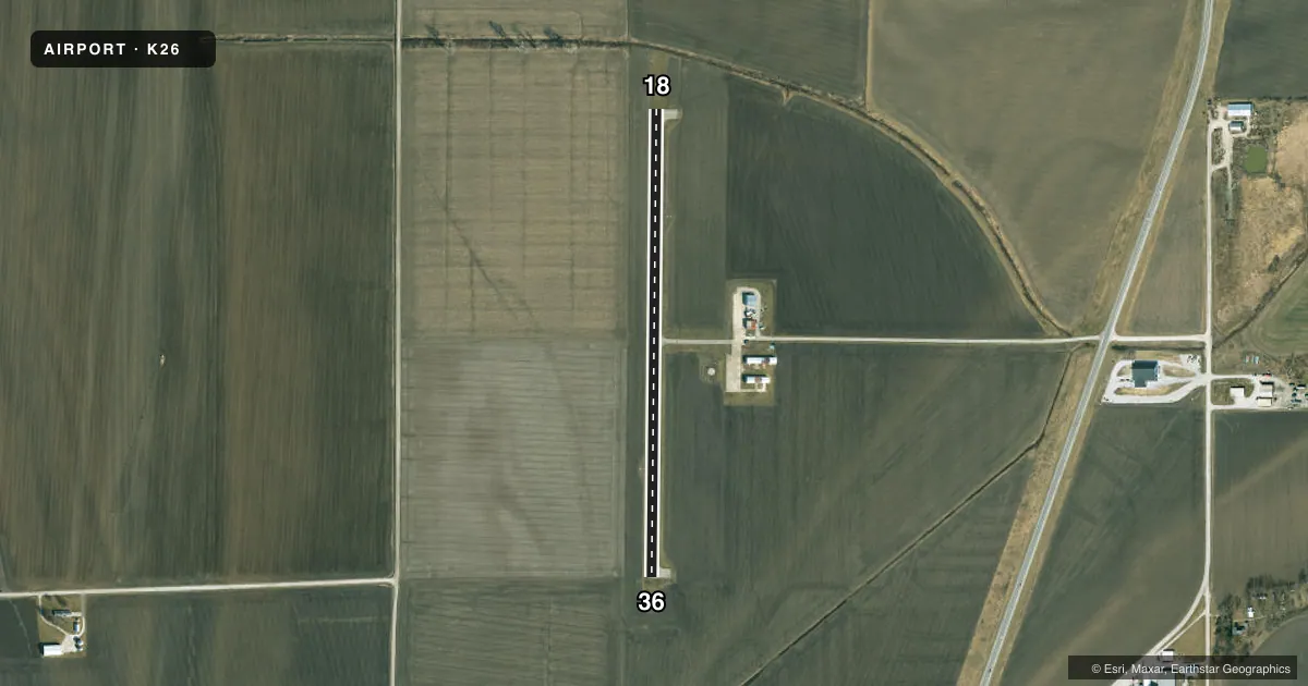
Airport sketch
Runways drawn to scale from FAA survey coordinates, rendered over satellite imagery. Not for navigation.
Approaches & charts
Services on the field
Fuel grades, oxygen, maintenance, ramp storage and lighting — as declared to the FAA by the airport operator.
Fuel & services
- Fuel
- 100LL
- Airframe repair
- Not available
- Power plant repair
- Not available
- Other services
- AGRI,INSTR
Ramp & ground
- Transient storage
- Tie-down
- Hangar
- Landing fee
- No fee published
- Customs
- Not available
- Beacon schedule
- SEE RMK
- Beacon
- White / Green (civil land)(WG)
- Wind indicator
- Lighted
- Segmented circle
- No
Fuel & FBOs
Cheapest 100LL and Jet A on the field and nearby. Always confirm with the FBO before taxi.
Airport notes
Surface conditions, obstructions, local procedures, lighting outages and other notes published with each FAA cycle.
General notes
- LOW LEVEL CROPS WITHIN 60 FT OF RY CNTRLN.
- FOR CD CTC KANSAS CITY ARTCC AT 913-254-8508.
Lighting notes
- DUSK-DAWN. MIRL RY 18/36 PRESET ON LOW INTST.
Fuel notes
- 100LLSELF-SERVE FUEL WITH CREDIT CARD.
Other notes
- MANAGERARPRT BOARD CHAIRMAN.
VFR map & nearby airports
VFR sectional. Tap any ICAO chip to open that airport.
Key facts · K26
Answer card- ICAO
- K26
- Name
- CARROLLTON MEML
- Location
- CARROLLTON, MISSOURI
- Elevation
- 670 ft MSL
- Traffic pattern altitude
- 1,670 ft MSL (1,000 AGL)
- Control tower
- Non-towered (use CTAF)
- Total runways
- 1
- Longest runway
- 18/36 · 2,600 ft
- Published ILS approaches
- 0
- Published frequencies
- 1
- Magnetic variation
- 4°
- Current flight rules
- VFR
- Current wind
- 000° at 0 kt
- Favored runway now
- –
Carrollton Meml Airport (K26) sits in Carrollton, Missouri. Field elevation is 670 ft MSL. The airport has one runway. Runway 18/36 is 2,600 ft asphalt, so plan performance with that length in mind. There is no control tower. CTAF is 122.9.
No ILS approaches are published here. Pattern altitude is not published, so use the standard 1,000 ft AGL pattern unless current local guidance says otherwise. The published remarks matter here. Medium intensity runway lights on 18/36 are preset on low intensity from dusk to dawn. Low level crops are within 60 ft of the runway centerline, so keep that in mind on final and in the climbout. Self-serve 100LL is available with credit card.
For clearance delivery, contact Kansas City ARTCC at 913-254-8508. If you need current operational details, check the current FAA Chart Supplement or call the airport operator directly before departure. This is a small non-towered field, so standard see-and-avoid and good radio discipline on CTAF matter.