METAR & TAF KRCM
Current METAR
Observed 18:35Z
KRCM 271835Z AUTO 20009KT 10SM CLR 34/23 A2983 RMK AO2
- Wind
- 200° @ 9 kt
- Visibility
- 10 SM
- Temp / Dew
- 34°C / 23°C
- Altimeter
- 29.83 inHg
- Clouds
- CLR
- Density alt
- 3,381 ft
- Ceiling
- Unlimited
- Rules
- VFR
Airport info & contacts
Manager on record, flight service, ARTCC, attendance schedule and pattern altitude — published by the FAA and refreshed every 28 days.
Location
- From city
- 3 NM NW
- VFR sectional
- KANSAS CITY
- ARTCC
- ZKC · KANSAS CITY
- NOTAM facility
- COU (NOTAM-D)
Airport manager
- Name
- CHRIS HOLLAND
- Phone
- 660-543-4916
- Address
- UNIVERSITY OF CENTRAL MISSOURI, 281 NW US 50 HWY, WARRENSBURG MO 64093
Flight service · Hours
- FSS COU
- COLUMBIA1-800-WX-BRIEF
- Attendance
- SAT · 0800-1700
- SUN · 0800-1600
- OCT - MAR · MON-FRI · 0700-1800
- APR- SEPT · MON-FRI · 0700- 1900
Frequencies
Tap any row to copy the frequency to your clipboard.
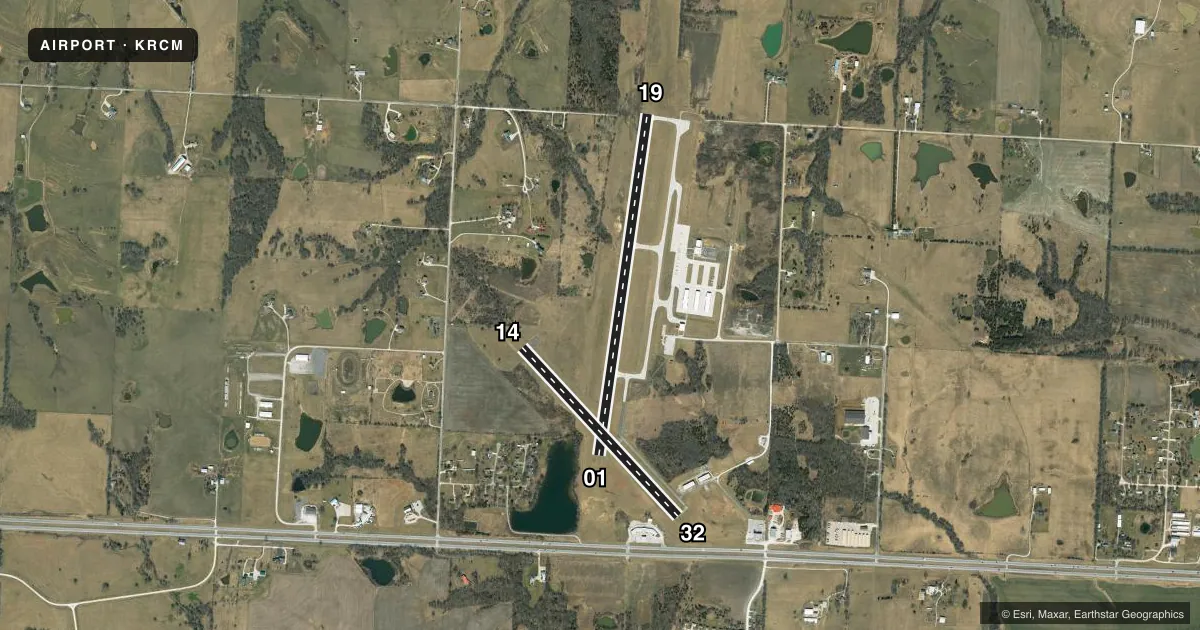
Runways & pattern
Full pagePattern entry · RWY 19
RIGHT TRAFFIC| Runway | Heading (°M) | Length | Surface | Traffic |
|---|---|---|---|---|
| 01/19Favored | 7° / 187° | 4,206 ft | CONC | 19 R |
| 14/32 | 136° / 316° | 2,801 ft | ASPH | 14 R |
Runway end performance
| End | TORA | TODA | ASDA | LDA | VGSI | Approach lights | Obstruction |
|---|---|---|---|---|---|---|---|
| 01 | — | — | — | — | PAPI 4-box left(3°) | — | 39', trees, 700' from thr, 165' R of cntrln, slope 12 |
| 19 | — | — | — | — | PAPI 4-box left(3°) | — | — |
| 14 | — | — | — | — | — | — | 20', trees, 480' from thr, 98' R of cntrln, slope 14 |
| 32 | — | — | — | — | — | — | 15', road, 375' from thr, 125' R of cntrln, slope 11 |
Declared distances in feet. TORA = takeoff run available, TODA = takeoff distance, ASDA = accelerate-stop, LDA = landing distance.
Airport sketch
Runways drawn to scale from FAA survey coordinates, rendered over satellite imagery. Not for navigation.
Approaches & charts
Services on the field
Fuel grades, oxygen, maintenance, ramp storage and lighting — as declared to the FAA by the airport operator.
Fuel & services
- Fuel
- 100LL
- Oxygen (bottled)
- Not available
- Oxygen (bulk)
- Not available
- Airframe repair
- Not available
- Power plant repair
- Not available
- Other services
- CHTR,GLD,INSTR,RNTL,SURV,TOW
Ramp & ground
- Transient storage
- Tie-down
- Hangar
- Landing fee
- No fee published
- Customs
- Not available
- Lighting schedule
- SEE RMK
- Beacon schedule
- SS-SR
- Beacon
- White / Green (civil land)(WG)
- Wind indicator
- Lighted
- Segmented circle
- Yes
Fuel & FBOs
Cheapest 100LL and Jet A on the field and nearby. Always confirm with the FBO before taxi.
Airport notes
Surface conditions, obstructions, local procedures, lighting outages and other notes published with each FAA cycle.
General notes
- SOUTH 100 FT OF APRON & EXIT RAMP LCTD 1250 FT N OF RWY 01 THR HAS SAME PAVEMENT STRENGTH AS RWY 01/19; REMAINDER OF APRON NOT FULL STRENGTH.
- LIMITED SIGHT DSTC FM RWY 14 THR AREA TO RWY 19 THR AND FM RWY 19 THR TO RWY 32 THR AREA.
- HIGH VOL STUDENT TRNG INVOF ARPT FM 0700-1730 LCL MON THRU FRI.
- FOR CD CTC WHITEMAN APCH AT 660-687-3132. WHEN WHITEMAN APCH IS CLSD, CTC KANSAS CITY ARTCC AT 913-254-8508.
Lighting notes
- ACTVT REIL RWY 14 & 32; PAPI RWY 01 & 19; MIRL RWY 01/19 & 14/32 - CTAF.
Approach & departure obstructions
- 01CALM WIND RWY.
Other notes
- CTC LN SVC FOR AVAILABILITY
- MANAGER660-422-1110
VFR map & nearby airports
VFR sectional. Tap any ICAO chip to open that airport.
Key facts · KRCM
Answer card- ICAO
- KRCM
- Name
- SKYHAVEN
- Location
- WARRENSBURG, MISSOURI
- Elevation
- 797.9 ft MSL
- Traffic pattern altitude
- 1,797.9 ft MSL (1,000 AGL)
- Control tower
- Non-towered (use CTAF)
- Total runways
- 2
- Longest runway
- 01/19 · 4,206 ft
- Published ILS approaches
- 0
- Published frequencies
- 6
- Magnetic variation
- 1°
- Current flight rules
- VFR
- Current wind
- 200° at 9 kt
- Favored runway now
- RWY 19
SKYHAVEN is in Warrensburg, Missouri. The field elevation is 797.9 ft MSL. It has two runways. The longest is 01/19 at 4,206 ft, with 14/32 measuring 2,801 ft. There is no control tower, so use CTAF 123.0 for traffic calls. Pattern altitude is not published. For light piston traffic, use 1,000 ft AGL unless the current Chart Supplement says otherwise.
No ILS approaches are published here. That matters if you are planning an arrival in lower weather. The airport sits near Whiteman airspace, so get current clearance and approach handling before you go in. Published remarks also note heavy student training from 0700 to 1730 local Monday through Friday. Expect busy pattern work during those hours.
UCM Aviation is on the field. It carries 100LL. If you need line service or want to confirm availability, call them at (660) 543-4921. Runway 01 is listed as the calm wind runway. Runway end identifier lights are active on 14 and 32. PAPI is installed on 01 and 19. Medium intensity runway lights are installed on both runways. The south 100 ft of the apron and the exit ramp 1,250 ft north of the 01 threshold have runway-strength pavement. The rest of the apron is not full strength. There is also limited sight distance between the 14 threshold area and the 19 threshold area, plus between the 19 threshold area and the 32 threshold area. Check the current Chart Supplement for any local procedures before flying in.